CUET PG Geography Question Paper 2024: Download Question paper with Solution PDF
- Question Paper 2025
- Question Paper 2024
- Question Paper 2023
- Mathematics Papers
- Statistics Question Paper
- English Question Paper
- Chemistry Question Paper
- Pol. Sci. Question Paper
- History Question Paper
- Commerce Question Papers
- Life Science Papers
- Geology Question Papers
- Journalism Question Paper
- B.Ed. HSS Question Paper
- Botany Question Paper
- B.Ed. Question Papers


Content Writer | Updated On - Mar 11, 2025
CUET PG Geography Question Paper 2024 is available here for download. NTA conducted CUET PG Geography paper 2024 on from March 11 in Shift 2. CUET PG Question Paper 2024 is based on objective-type questions (MCQs). According to latest exam pattern, candidates get 105 minutes to solve 75 MCQs in CUET PG 2024 Geography question paper.
CUET PG Geography Question Paper 2024 PDF Download
| CUET PG Pharmacy Question Paper 2024 with Answer Key |  Download Download |
Check Solutions |
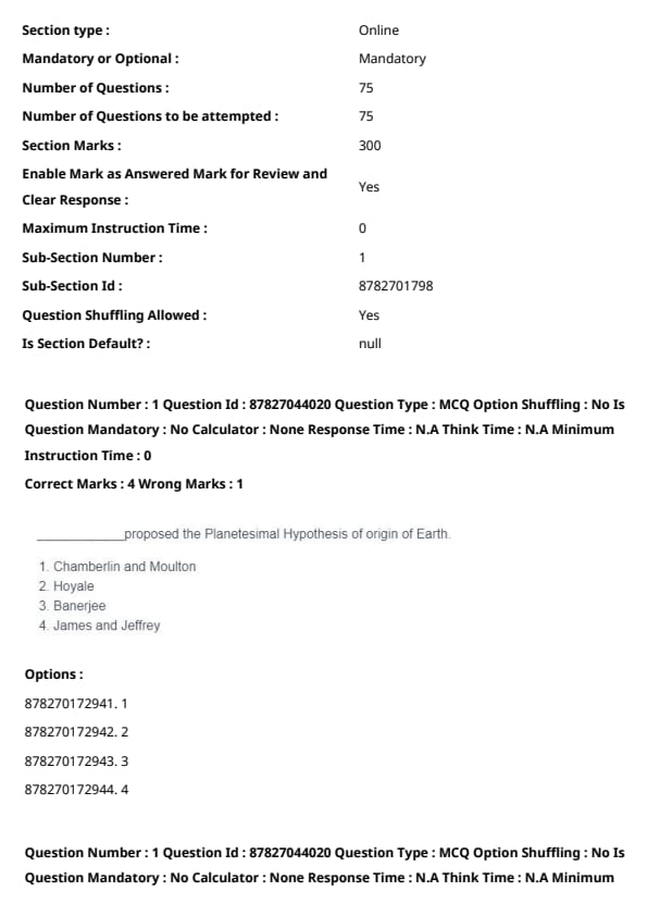
_________ proposed the Planetesimal Hypothesis of origin of Earth.
View Solution
The Planetesimal Hypothesis, introduced by Chamberlin and Moulton, describes the Earth's formation through the gradual accumulation of small solid celestial bodies called planetesimals. Quick Tip: Memorizing key scientific theories along with their proponents can greatly improve your recall for Earth science topics.
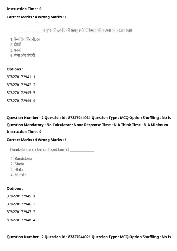
Quartzite is a metamorphosed form of _________.
View Solution
Quartzite is the result of sandstone undergoing metamorphic processes, where heat and pressure cause quartz grains to recrystallize into an interlocking structure. Quick Tip: Familiarize yourself with the rock cycle and its transformations to answer geology questions effectively.
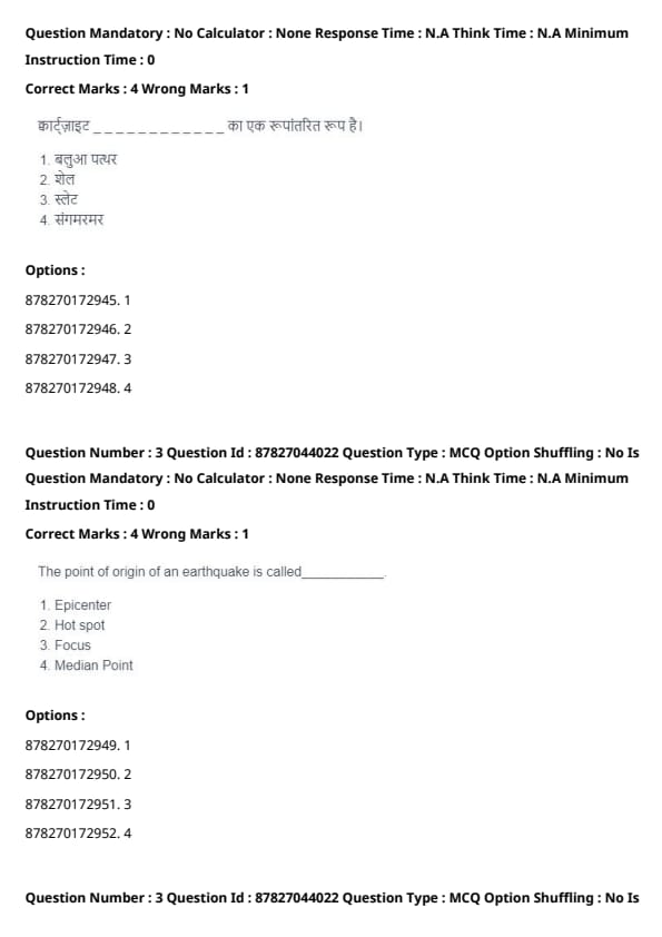
The point of origin of an earthquake is called _________.
View Solution
The focus refers to the precise location within the Earth where seismic energy is released, initiating an earthquake. The epicenter is the point directly above the focus on Earth's surface. Quick Tip: Remember the distinction between focus and epicenter to improve your understanding of seismic concepts.
An oval-shaped mound composed of glacial drift is called _________.
View Solution
Drumlins are streamlined, oval-shaped hills formed by glacial drift. These features are composed of till and align with the direction of glacial movement. Quick Tip: Review glacial landforms like drumlins, eskers, and moraines for geography-based topics.
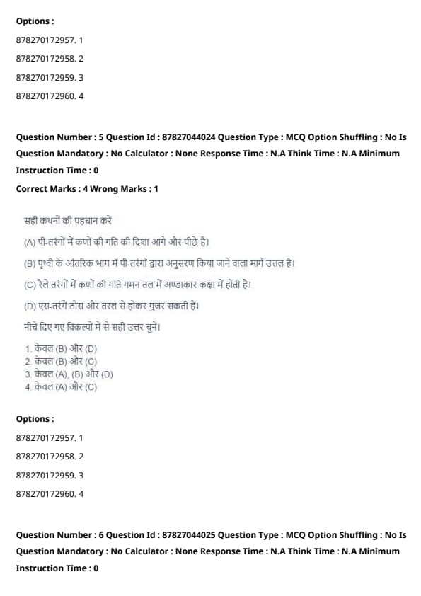
Identify the correct statements:
View Solution
- (A) True: P-waves move particles back and forth in the direction of wave propagation.
- (B) False: P-waves actually follow a refracted path that can be convex or concave depending on Earth's layers.
- (C) True: Rayleigh waves induce an elliptical motion of particles in their propagation plane.
- (D) False: S-waves only travel through solid materials, not through liquids. Quick Tip: Knowing the properties of different seismic waves (P-waves, S-waves, Rayleigh waves) is key for earthquake concepts.
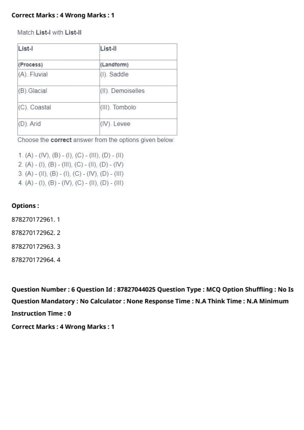
Match List-I with List-II:

Choose the correct answer from the given options:
View Solution
- (A) Fluvial processes create levees.
- (B) Glacial processes form saddles.
- (C) Coastal processes produce tombolos.
- (D) Arid processes result in the formation of Demoiselles. Quick Tip: Connecting landforms to their formation processes is crucial for geography-based questions.
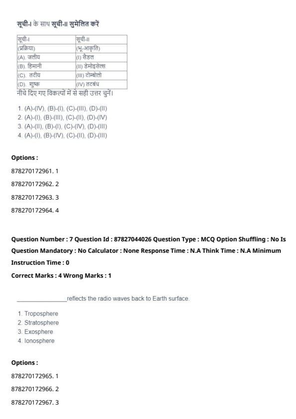
_________ reflects the radio waves back to Earth's surface.
View Solution
The ionosphere contains a high concentration of ionized particles, which reflect radio waves back toward the Earth's surface, allowing long-distance communication. Quick Tip: Understand the role of different atmospheric layers to better answer Earth science-related questions.
The difference between the observed mean temperature of a location and the mean temperature expected based on its latitude is known as _________.
View Solution
A thermal anomaly refers to the deviation between a place's actual mean temperature and the expected mean temperature for its latitude, often influenced by geographical or environmental factors. Quick Tip: Familiarize yourself with key climate terms like thermal anomaly and lapse rate for better clarity in meteorology topics.
The ratio of absolute humidity to the maximum moisture capacity of air at a given temperature is termed as _________.
View Solution
Relative humidity is defined as the percentage ratio of the amount of water vapor present in the air to the maximum amount the air can hold at a given temperature. Quick Tip: Understanding humidity types and their calculations is key to solving climate and weather-related questions.
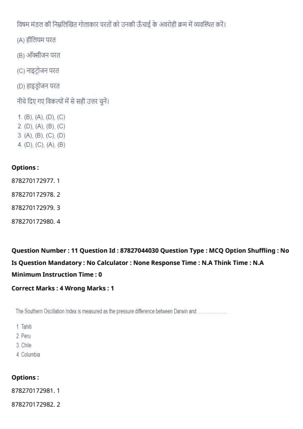
Arrange the following spherical layers of the Heterosphere in descending order of their height:
View Solution
In the heterosphere, gases are stratified according to their molecular weight. Hydrogen, being the lightest gas, occupies the highest layer, followed by helium, oxygen, and nitrogen in descending order. Quick Tip: Visualizing atmospheric layers by their composition can greatly improve retention of geoscience concepts.
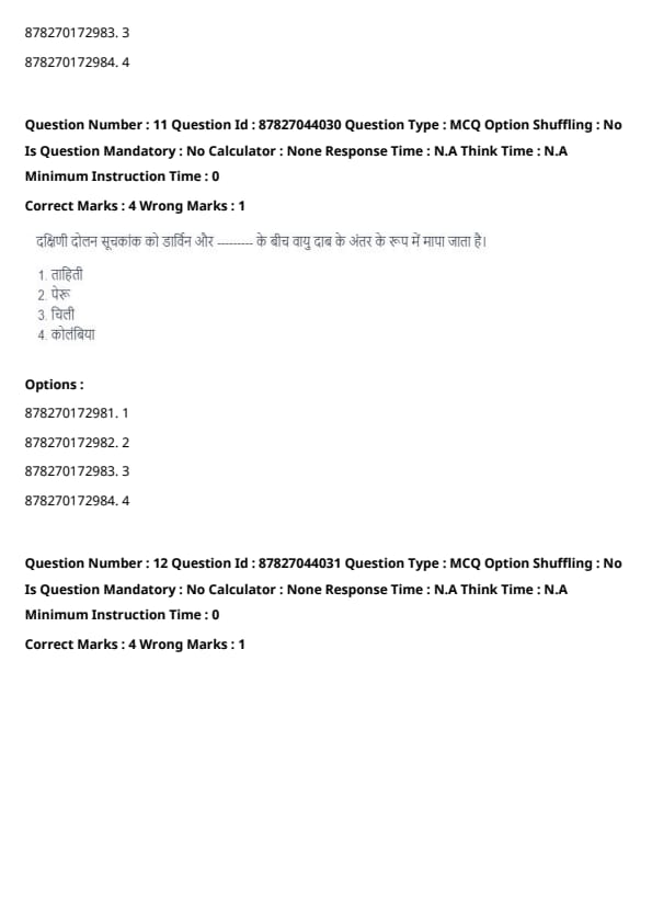
The Southern Oscillation Index is measured as the pressure difference between Darwin and _________.
View Solution
The Southern Oscillation Index (SOI) is calculated based on the atmospheric pressure difference between Darwin (Australia) and Tahiti. It serves as an important indicator for predicting El Niño and La Niña climate phenomena. Quick Tip: Link atmospheric pressure variations to weather patterns like El Niño and La Niña for better understanding.
Identify the correct statements about Tropical Cyclones.
View Solution
- (A) True: The Eye Wall is the most intense region of a tropical cyclone, featuring the highest wind speeds.
- (B) False: Tropical cyclones are not formed due to frontal activity; instead, they result from warm ocean temperatures and low-pressure systems.
- (C) False: The matured stage of a cyclone is known as a Tropical Cyclone, while a Tropical Depression refers to an earlier developmental stage.
- (D) True: Cumulonimbus clouds are the dominant cloud type found in tropical cyclones. Quick Tip: Understand the lifecycle, structure, and characteristics of tropical cyclones for meteorology-related questions.
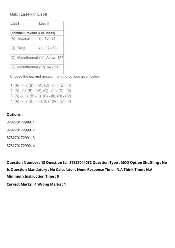
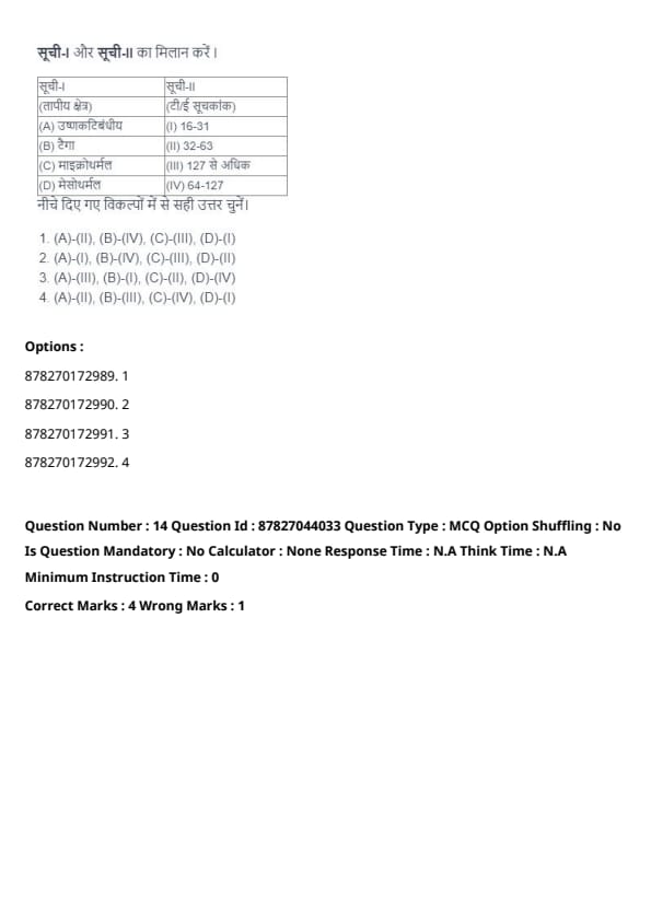
Match List-I with List-II:

Choose the correct answer from the given options:
View Solution
- (A) Tropical: T/E Index Above 127.
- (B) Taiga: T/E Index 16 - 31.
- (C) Microthermal: T/E Index 32 - 63.
- (D) Mesothermal: T/E Index 64 - 127. Quick Tip: Memorizing the classification of climate zones based on the T/E index helps tackle geography-related questions effectively.
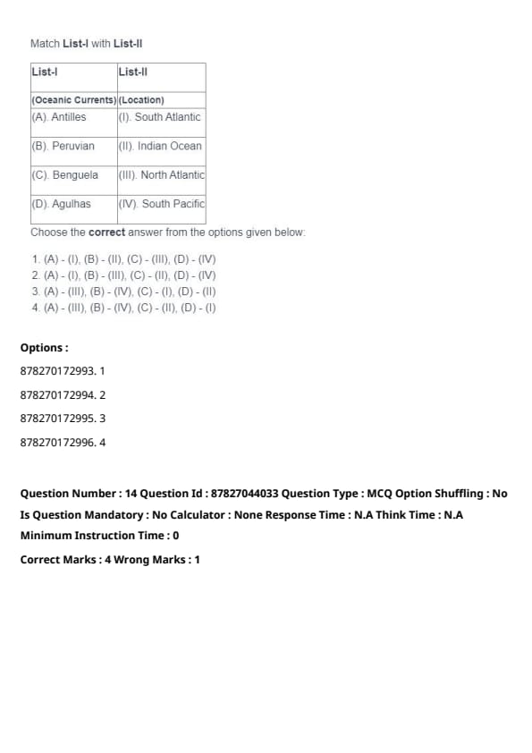
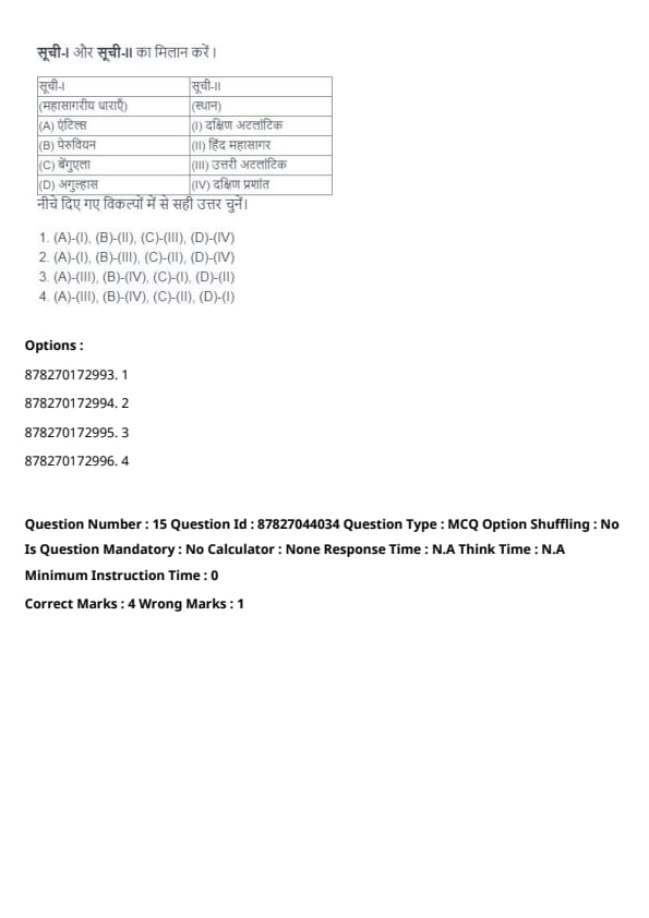
Match List-I with List-II:

Choose the correct answer from the given options:
View Solution
- (A) Antilles: Located in the North Atlantic Ocean.
- (B) Peruvian: Found in the South Pacific Ocean.
- (C) Benguela: Situated in the South Atlantic Ocean.
- (D) Agulhas: Present in the Indian Ocean. Quick Tip: Associate key ocean currents with their corresponding oceans for better retention in geography topics.
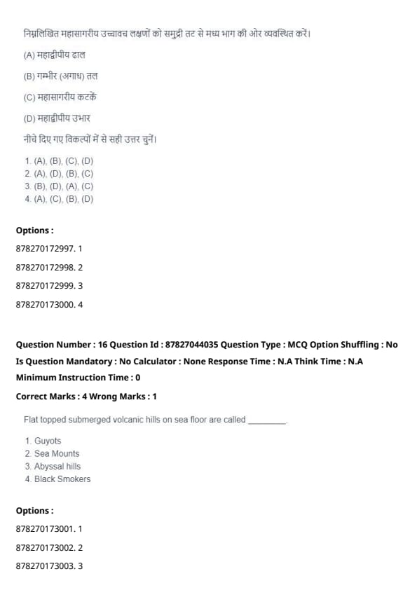
Arrange the following Oceanic Relief features from coast to the central part:
View Solution
The correct sequence of oceanic relief features from the coast to the central ocean basin is:
(A) Continental Slope → (D) Continental Rise → (B) Abyssal Floor → (C) Oceanic Ridges. Quick Tip: Visualizing ocean floor profiles helps improve understanding of marine geology concepts.
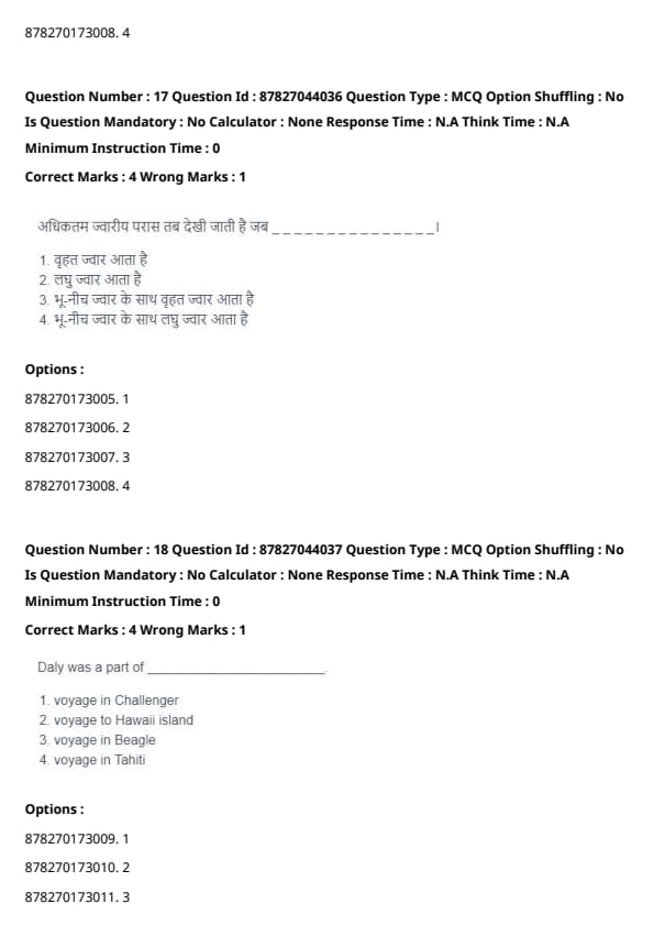
Flat-topped submerged volcanic hills on the sea floor are known as _________.
View Solution
Guyots are underwater volcanic mountains with flattened tops. This distinctive shape results from erosion and subsidence after the volcanic peak has emerged and later submerged. Quick Tip: Differentiate between seamounts (pointed peaks) and guyots (flat tops) for clarity in marine geology.
The greatest tidal range occurs when _________.
View Solution
The largest tidal range occurs when a spring tide aligns with the Perigean tide, which happens when the Moon is closest to Earth (perigee), amplifying gravitational effects. Quick Tip: Memorize the influence of the Moon's position on tidal patterns for understanding coastal geography.
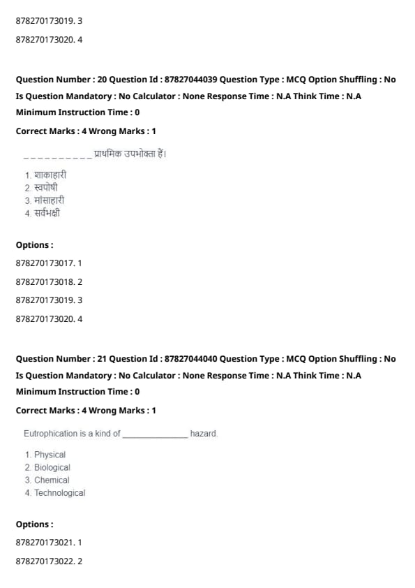
Daly was part of _________.
View Solution
Daly was known for his geological work on coral reefs and volcanic islands during his voyage to Hawaii. His subsidence theory on coral reef formation is a significant contribution to marine geology. Quick Tip: Review key expeditions and their scientific contributions for better understanding of oceanography.
The term "Ecology" was first coined by _________.
View Solution
The term "Ecology" was introduced by Ernst Haeckel in 1866 to describe the study of relationships between living organisms and their environment. Quick Tip: Memorize key scientists and their contributions to improve accuracy in biology-related questions.
_________ are considered the primary consumers in an ecosystem.
View Solution
Herbivores are classified as primary consumers because they directly consume producers (plants) in the food chain. Examples include deer, rabbits, and cows. Quick Tip: Familiarize yourself with the ecological pyramid to understand energy flow in ecosystems.
Eutrophication is a kind of ______________ hazard.
View Solution
Eutrophication is primarily a biological hazard. It occurs when there is an excess of nutrients (such as nitrogen and phosphorus) in water bodies, leading to excessive growth of algae and other aquatic plants. This disrupts the natural balance of the ecosystem and affects aquatic life. Quick Tip: Eutrophication primarily affects aquatic ecosystems, causing oxygen depletion and impacting biodiversity.
Identify the correct statements.
View Solution
- Statement (A) is correct as Synecology refers to the study of relationships among different species within a community.
- Statement (B) is also correct because Community Ecology examines interactions between different species in the same area.
- Statement (C) is incorrect because the study of individual species' relationships to their environment is termed Autecology, not Biome Ecology.
- Statement (D) is incorrect, as Population Ecology involves studying interactions within and among populations of organisms. Quick Tip: Remember, Synecology refers to communities of species, while Autecology focuses on individual species in their environment.
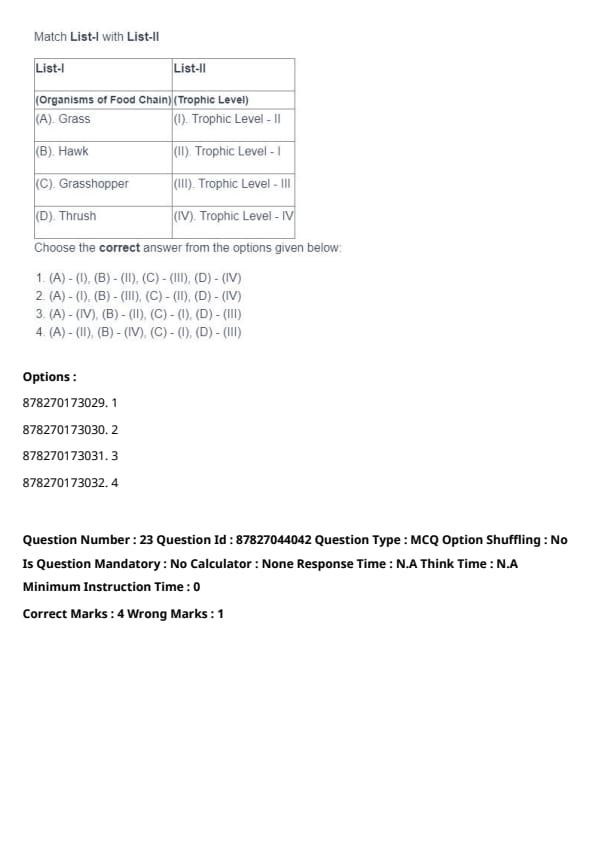
Match List-I with List-II

Choose the correct answer from the options given below:
View Solution
- Grass is at Trophic Level I (primary producers) as it provides food for herbivores.
- Hawk is a predator at Trophic Level IV (top predator in the food chain).
- Grasshopper is at Trophic Level II (herbivore) because it feeds on plants.
- Thrush is at Trophic Level III (secondary consumer) as it feeds on smaller animals like insects.
Quick Tip: Primary producers (like plants) are always at Trophic Level I, and predators are typically at higher trophic levels.
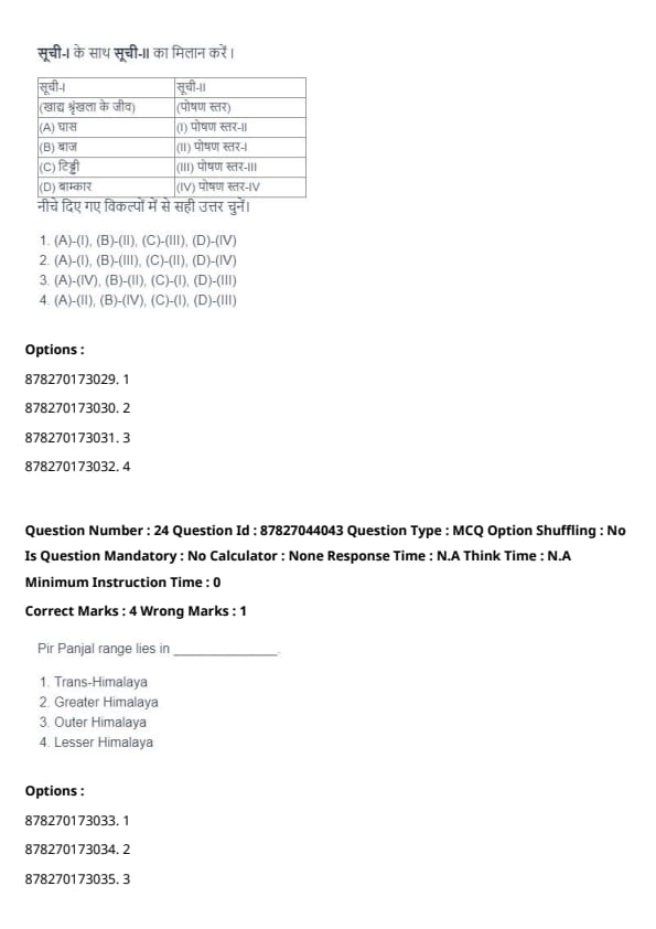
Pir Panjal range lies in ______________.
View Solution
The Pir Panjal range is part of the Lesser Himalayas. It lies to the south of the main Himalayan ranges and is known for its significant geographical and climatic features. Quick Tip: The Lesser Himalayas are situated between the Great Himalayas and the outer ranges.
The thermal concept of the origin of monsoon was propounded by ______________.
View Solution
The thermal concept of the origin of the monsoon was propounded by Halley. He suggested that the monsoon winds are caused by differential heating between land and sea. Quick Tip: Halley's theory explains the heating differences between land and sea as the primary factor for monsoon formation.
The best quality of coal with the highest proportion of carbon and low moisture content is called ______________.
View Solution
Anthracite is the highest grade of coal with the greatest carbon content and the least moisture, making it the best quality coal used for energy production. Quick Tip: Anthracite coal is harder, has more carbon, and burns cleaner than lower grade coals.
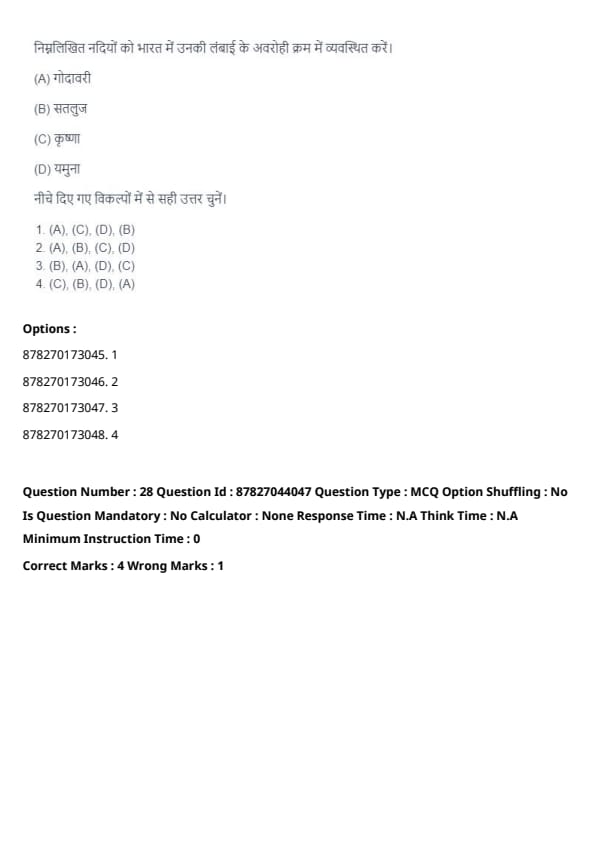
Arrange the following rivers in descending order of their length in India.
View Solution
The correct order of rivers based on their length in India is:
- Godavari (1,465 km)
- Krishna (1,400 km)
- Yamuna (1,376 km)
- Sutlej (1,450 km)
Thus, the correct sequence is (A), (C), (D), (B). Quick Tip: Knowing the major rivers in India and their respective lengths can help with geography-based questions.
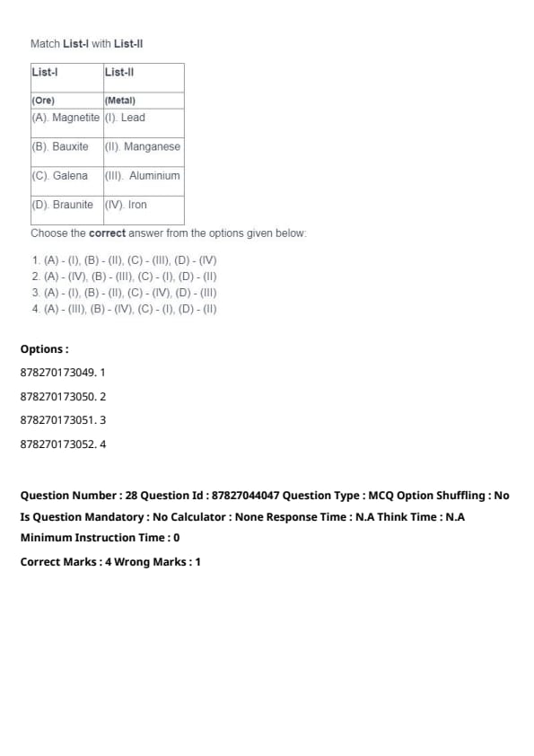
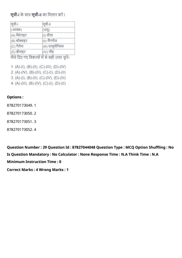
Match List-I with List-II

Choose the correct answer from the options given below:
View Solution
- Magnetite is an ore of iron (IV).
- Bauxite is an ore of aluminium (III).
- Galena is an ore of lead (I).
- Braunite is an ore of manganese (II).
Thus, the correct matches are (A) - (I), (B) - (III), (C) - (II), (D) - (IV). Quick Tip: Remember that ores correspond to the metals they yield. Magnetite is associated with iron, Bauxite with aluminium, and so on.
Identify the correct statements about soils of India.
View Solution
- Statement (A) is incorrect because Khadar refers to the newer, flood-affected Alluvial soil.
- Statement (B) is correct because Black soil, rich in clay, retains more water compared to other soil types.
- Statement (C) is correct because Desert soils are generally poor in both organic matter and mineral salts.
- Statement (D) is incorrect, as Red soils are widespread and cover large areas in India, mainly in the southern and eastern regions.
Quick Tip: Khadar soils are found in floodplains, while Bhangar (older Alluvial soil) is less fertile.
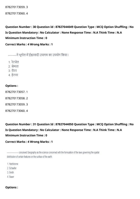
______________ applied teleological approach in Geography.
View Solution
Ritter applied a teleological approach in geography, which means he believed that geographical features and human society evolved through purposeful, goal-oriented processes. He is known for his theory of "Lebensraum" (living space). Quick Tip: Teleological theories in geography focus on the idea of purposeful evolution of geography and human settlements.
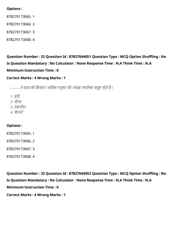
______________ conceived Geography as the science concerned with the formulation of the laws governing the spatial distribution of certain features on the surface of the earth.
View Solution
Schaefer defined geography as the study of spatial patterns and the formulation of laws that govern the distribution of features on the Earth's surface. He emphasized geography as a systematic and analytical discipline. Quick Tip: Focus on Schaefer’s emphasis on spatial laws to understand his contribution to modern geography.
______________ observed that the farmers were 'spatial satisfiers' rather than 'economic men'.
View Solution
Wolpert proposed that farmers are 'spatial satisfiers,' meaning their decisions are influenced more by environmental and social conditions rather than solely economic factors, challenging the traditional 'economic man' theory. Quick Tip: Understand the concept of ‘spatial satisfiers’ as it highlights the role of geographic factors in decision-making.
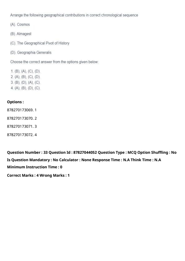
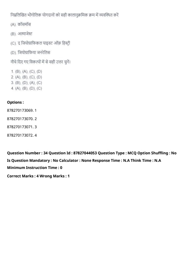
Arrange the following geographical contributions in correct chronological sequence.
View Solution
The correct chronological order is:
- (B) Almagest by Ptolemy (2nd century AD)
- (D) Geographia Generalis by Varenius (1650)
- (A) Cosmos by Humboldt (1845)
- (C) The Geographical Pivot of History by Mackinder (1904)
Quick Tip: Chronological knowledge of major geographical contributions helps in understanding the evolution of geographic thought.
Identify the correct statements.
View Solution
- Statement (A) is incorrect: Welfare Geography emphasizes social betterment but does not focus solely on revolutionary theory.
- Statement (B) is correct: Knox emphasized mapping social and spatial variations in life quality.
- Statement (C) is correct: Behavioural Geography is based on the ‘economic man’ assumption.
- Statement (D) is incorrect: Stewart contributed to social physics, but not in this specific context.
Quick Tip: Focus on key geographers' contributions for conceptual clarity in geography theories.
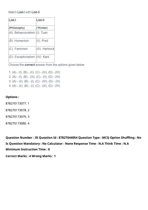
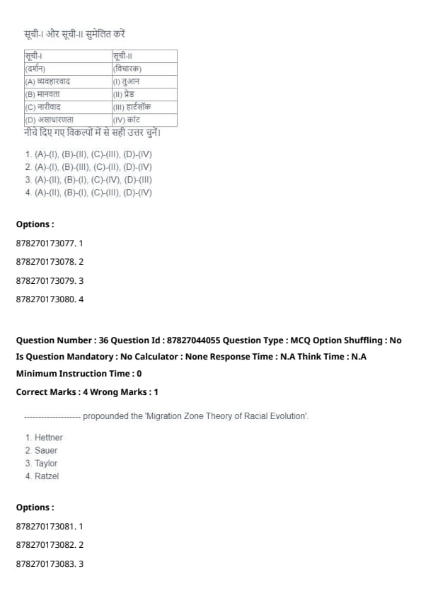
Match List-I with List-II

Choose the correct answer from the given options:
View Solution
- Behaviouralism is associated with Tuan.
- Humanism is linked to Pred.
- Feminism is associated with Hartsock.
- Exceptionalism is connected with Kant.
Thus, the correct match is (A) - (I), (B) - (II), (C) - (III), (D) - (IV). Quick Tip: Linking philosophers with their respective theories improves accuracy in matching questions.
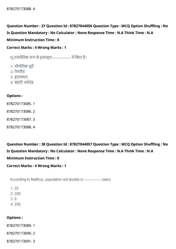
______________ propounded the ‘Migration Zone Theory of Racial Evolution’.
View Solution
The 'Migration Zone Theory of Racial Evolution' was introduced by Griffith Taylor. This theory emphasizes how racial characteristics evolved as populations migrated across different environmental zones. Quick Tip: Taylor’s theory connects human migration patterns with environmental adaptation and racial characteristics.
Geopolitically, Israel is located in ______________.
View Solution
Israel is situated in the Rimland, a strategic geopolitical zone defined by Nicholas Spykman. The Rimland region is crucial for global dominance as it encircles the Eurasian landmass, controlling trade routes and power balance. Quick Tip: Understanding Spykman’s Rimland theory is key to grasping geopolitical strategies in global politics.
According to Malthus, population will double in ______________ years.
View Solution
Malthus proposed that the population grows exponentially and, if left unchecked, would double approximately every 25 years. This theory warns of potential crises where population growth outpaces food production. Quick Tip: Malthus’ theory highlights the risks of population growth surpassing resource availability, emphasizing sustainable development concerns.
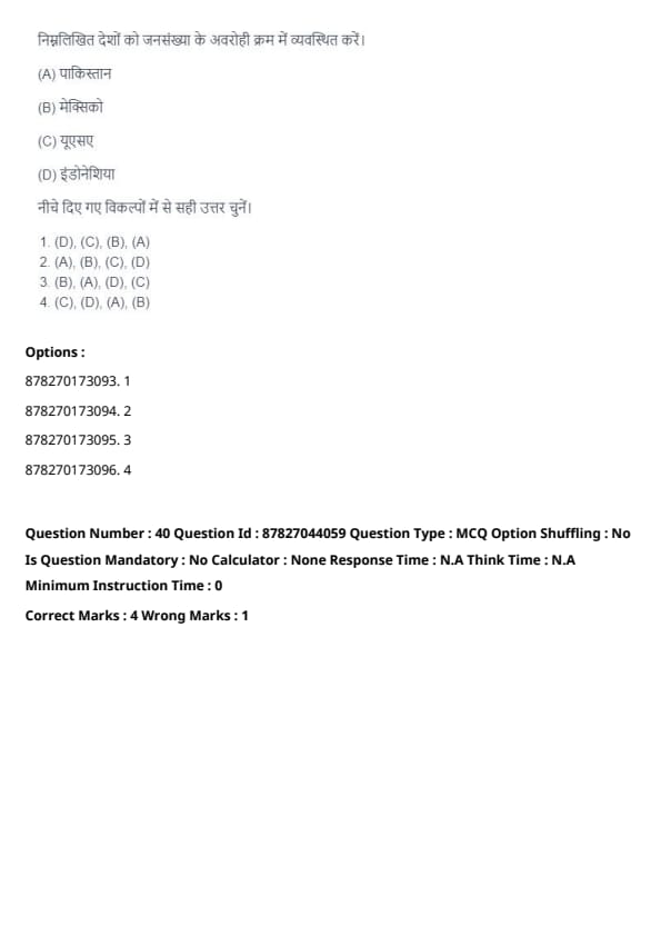
Arrange the following countries in descending order of population.
View Solution
Based on global population statistics:
- (C) USA has the highest population among these nations.
- (D) Indonesia follows as the second most populous.
- (A) Pakistan ranks third.
- (B) Mexico has the smallest population in this group.
Thus, the correct sequence is (C), (D), (A), (B). Quick Tip: Keep updated with recent population data for accuracy in demographic questions.
Identify correct statements with reference to urbanisation.
View Solution
- Statement (A) is incorrect: The level of urbanisation in India is below the world average.
- Statement (B) is incorrect: The rural population worldwide is significantly higher than the urban population.
- Statement (C) is correct: Less Developed Countries contribute a larger proportion of the world’s urban population.
- Statement (D) is correct: South America has a higher urbanisation rate than Europe.
Quick Tip: Focus on demographic trends and regional urbanisation patterns for accuracy in geography-related questions.
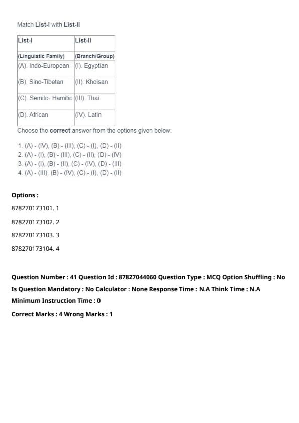
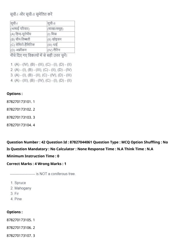
Match List-I with List-II

Choose the correct answer from the options given below:
View Solution
- Indo-European is associated with Latin (IV).
- Sino-Tibetan corresponds to Thai (III).
- Semito-Hamitic is linked to Khoisan (II).
- African is connected to Egyptian (I).
Thus, the correct matching is (A) - (IV), (B) - (III), (C) - (I), (D) - (II). Quick Tip: Understanding the primary language families and their subcategories is useful for matching-type questions.
______________ is NOT a coniferous tree.
View Solution
Mahogany belongs to the category of broadleaf trees and does not fall under coniferous trees. Conifers such as Spruce, Fir, and Pine belong to the Pinaceae family. Quick Tip: Coniferous trees generally have needle-like leaves, whereas broadleaf trees like Mahogany feature wider leaves.
______________ horizon is known as the Zone of Eluviation.
View Solution
The A horizon is termed the zone of eluviation, where minerals and nutrients are transported downward due to water percolation. This process plays a crucial role in soil formation. Quick Tip: Eluviation involves the washing out of minerals from the soil layers, predominantly occurring in the A horizon.
The Nationally Determined Contributions (NDCs) approach was introduced in ______________.
View Solution
The Nationally Determined Contributions (NDCs) framework was established under the Paris Agreement in 2015. NDCs represent commitments by individual nations to mitigate greenhouse gas emissions and combat climate change. Quick Tip: The Paris Agreement introduced country-specific climate action plans under the NDC framework.
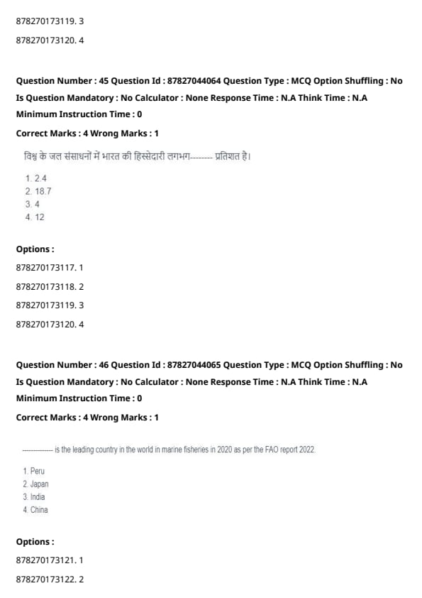
India accounts for about ______________ per cent of the world’s water resources.
View Solution
India holds approximately 4% of the world's total water resources. However, due to its large population and irregular distribution of water sources, the country faces challenges in water availability. Quick Tip: Despite possessing a small share of global water resources, India's large population intensifies water scarcity issues.
______________ is the leading country in the world in marine fisheries in 2020 as per the FAO report 202(2).
View Solution
As per the FAO 2022 report, China emerged as the top producer in marine fisheries globally. China's dominance in this sector is attributed to its extensive coastline and advancements in fishing technology. Quick Tip: China consistently leads in global marine fish production, followed by nations like Peru and India.
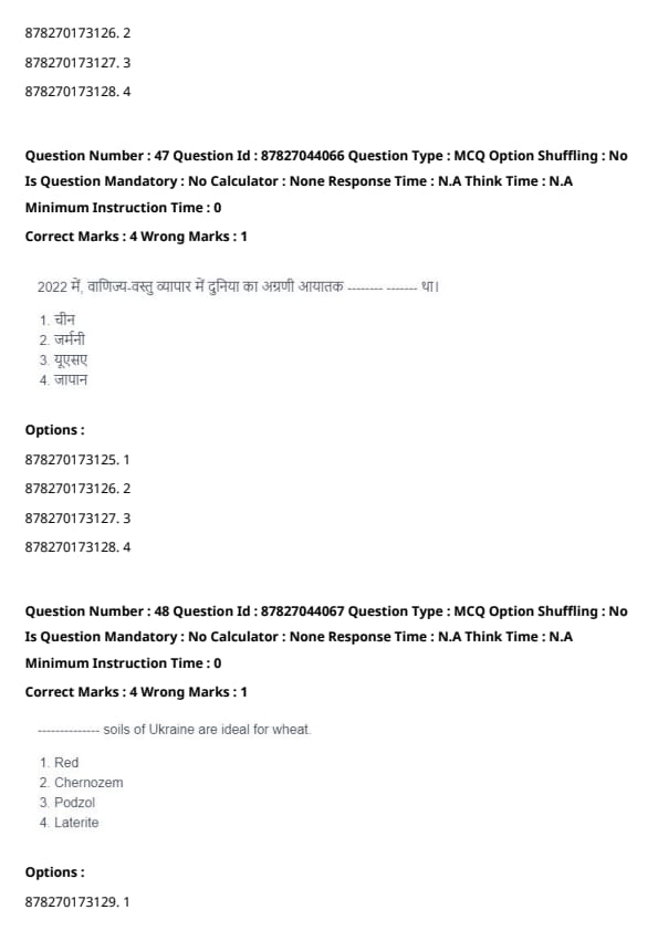
In 2022, the world's leading importer in merchandise trade was ______________.
View Solution
In 2022, the United States was the largest importer in global merchandise trade. The country's high demand for goods, coupled with its economic strength, contributes to its significant import volume. Quick Tip: Studying global trade patterns and major economies helps in understanding import-export trends.
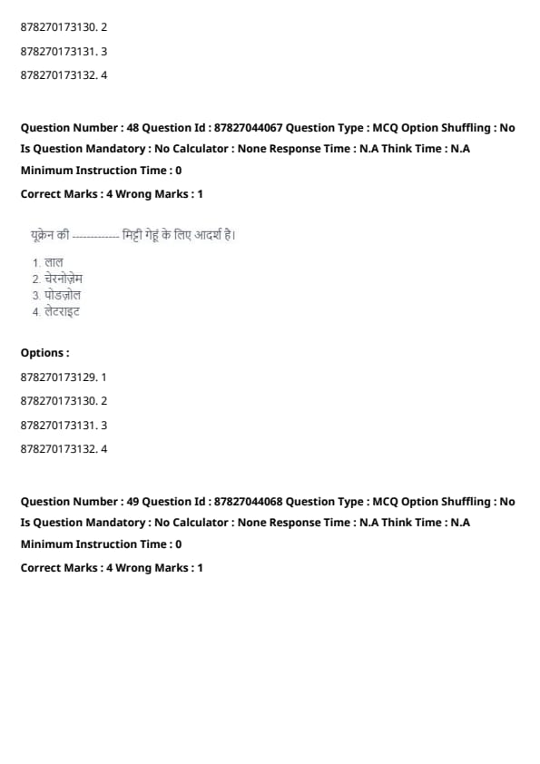
______________ soils of Ukraine are ideal for wheat.
View Solution
Chernozem soils, which are rich in organic matter and nutrients, are highly suitable for wheat cultivation. These soils are widespread in Ukraine and are known for their high fertility, making them ideal for agricultural production. Quick Tip: Chernozem soils, often referred to as "black soils," have exceptional fertility due to their high humus content.
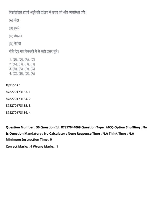
Arrange the following airports from south to north.
View Solution
The airports arranged in order from south to north are:
- Harare (Zimbabwe) - Located in the southernmost part.
- Jeddah (Saudi Arabia) - Positioned north of Harare.
- Nairobi (Kenya) - Situated north of Jeddah.
- Tehran (Iran) - The northernmost among these cities.
Thus, the correct sequence is (B), (A), (D), (C). Quick Tip: Knowing the latitudinal positions of major cities aids in arranging locations from south to north.
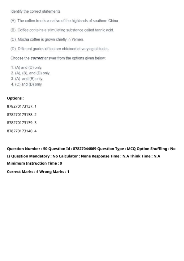
Identify the correct statements.
View Solution
- Statement (A) is incorrect: The coffee plant originates from Ethiopia, not China.
- Statement (B) is incorrect: Coffee contains caffeine, not tannic acid, as the primary stimulating compound.
- Statement (C) is correct: Mocha coffee is predominantly cultivated in Yemen.
- Statement (D) is correct: The quality and grade of tea vary depending on the altitude at which it is grown.
Therefore, the correct statements are (C) and (D). Quick Tip: Mocha coffee refers to a specific variety grown in Yemen, different from the flavored coffee drink of the same name.
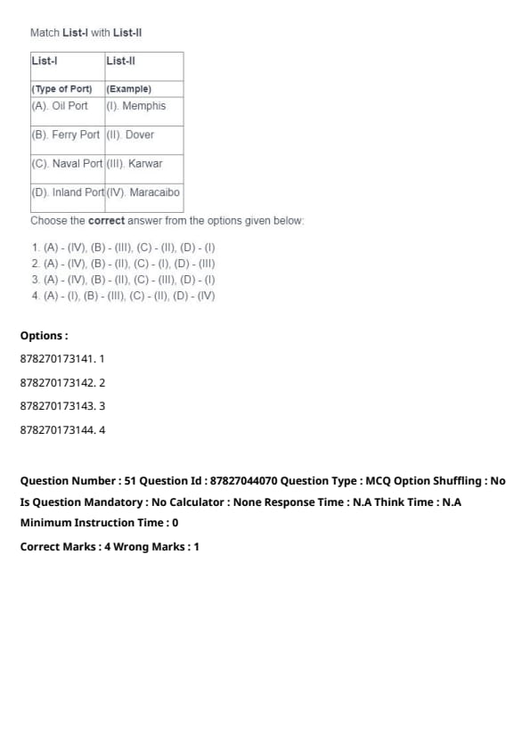
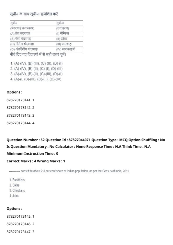
Match List-I with List-II

Choose the correct answer from the options given below:
View Solution
- Oil Ports are represented by Maracaibo (IV).
- Ferry Ports are represented by Dover (II).
- Naval Ports are represented by Karwar (III).
- Inland Ports are represented by Memphis (I).
Thus, the correct match is (A) - (IV), (B) - (II), (C) - (III), (D) - (I). Quick Tip: To identify the types of ports, consider their functions and locations.
______________ constitute about (2)3 per cent share of Indian population, as per the Census of India, 201(1)
View Solution
According to the Census of India 2011, Jains constitute about (2)3% of the Indian population. This minority group has a significant presence, especially in states like Gujarat and Rajasthan. Quick Tip: Keep in mind the major religious and cultural groups in India when answering questions about population statistics.
The leading coffee producing state in 2020-21 was ______________.
View Solution
In 2020-21, Karnataka was the leading coffee producing state in India, contributing the largest share of the country’s coffee production, particularly in regions like Coorg, Chikmagalur, and Hassan. Quick Tip: Karnataka is the hub of coffee cultivation in India, followed by Kerala and Tamil Nadu.
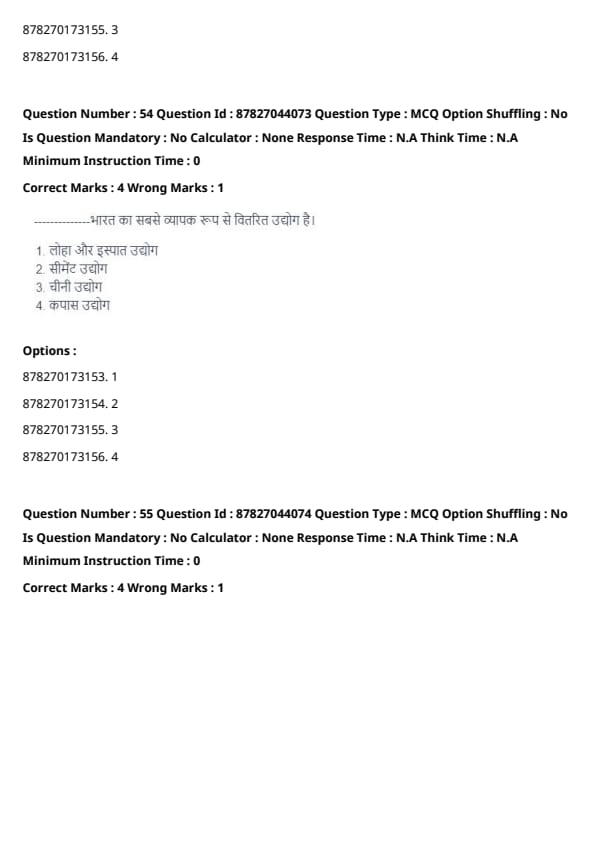
______________ is the most widely distributed industry of India.
View Solution
The cement industry is the most widely distributed industry in India, with numerous plants across the country, from Rajasthan to Andhra Pradesh. It is a key part of India's infrastructure development. Quick Tip: Cement production is widespread across India, driven by demand in construction and infrastructure projects.
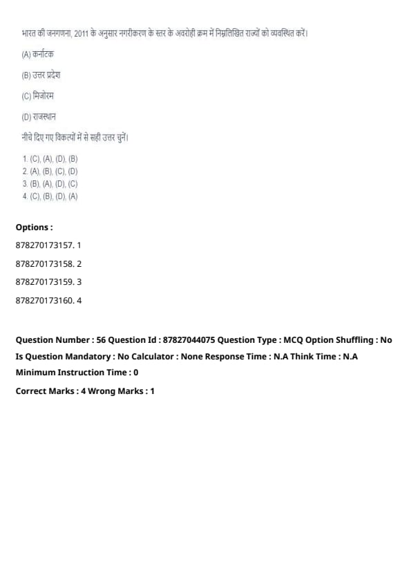
Arrange the following states in descending order of level of urbanisation, as per the Census of India, 201(1)
View Solution
Mizoram (C) has the highest level of urbanisation, followed by Karnataka (A). Rajasthan (D) and Uttar Pradesh (B) have lower levels of urbanisation. Quick Tip: Mizoram has the highest urbanisation rate in India, especially due to its small population and high urban concentration.
Identify the correct statements about regional planning and development in India.
View Solution
- The Hill Area Development Programme (HADP) was actually initiated during the Fourth Five Year Plan, not the Fifth. Thus, statement (A) is incorrect.
- The National Rural Employment Programme (NREP) was indeed first implemented in the Sixth Five Year Plan, so statement (B) is correct.
- The Rashtriya Sam Vikas Yojana (RSVY) was initiated in 2014-15 to focus on the development of backward areas, making statement (C) correct.
- Aspirational districts are assessed based on 5 broad socio-economic themes, as stated in statement (D), making it correct.
Therefore, the correct answer is (B), (C), and (D) only. Quick Tip: To remember specific schemes, note the exact planning periods and their associated objectives.
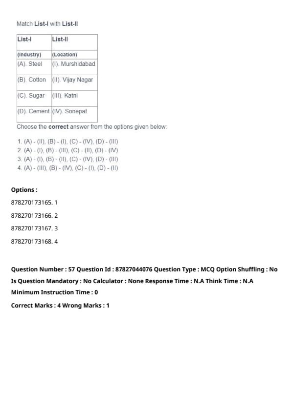
Match List-I with List-II

Choose the correct answer from the options given below:
View Solution
- The steel industry is located in Murshidabad (I).
- Cotton industry is located in Vijay Nagar (II).
- Sugar industry is located in Katni (III).
- Cement industry is located in Sonepat (IV).
Thus, the correct match is (A) - (I), (B) - (II), (C) - (III), (D) - (IV). Quick Tip: Learn industry locations based on the states they are prominent in to easily match industries and locations.
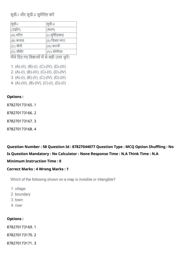
Which of the following shown on a map is invisible or intangible?
View Solution
A boundary on a map is an intangible concept, representing a demarcation of space, but it cannot be physically seen on the ground. A village, town, and river all refer to tangible entities. Quick Tip: Boundaries on maps are symbolic and represent the separation of territories.
In contouring, the existence of a ______________ surface is assumed.
View Solution
In contouring, the existence of a plain surface is assumed. This assumption helps in drawing contours that represent the elevation or depth on a relatively flat or uniform surface. Quick Tip: Remember that contour lines are drawn assuming a plain or level surface to represent changes in elevation accurately.
In one type of Climograph ______________ is represented on the Y axis and ______________ on the X axis.
View Solution
In one type of Climograph, the dry bulb temperature is typically represented on the Y-axis, and the relative humidity is plotted on the X-axis. This helps analyze temperature and humidity variations. Quick Tip: In Climographs, dry bulb temperature and relative humidity are plotted to analyze weather patterns effectively.
______________ is a type of surveying classified on the basis of purpose of the survey.
View Solution
Cadastral surveying is a type of survey that is categorized based on its specific purpose, primarily used for defining land boundaries, maintaining property records, and legal documentation. Quick Tip: Cadastral surveying is essential for mapping and recording property ownership.
______________ Gunter's chains equal 1 mile in Chain Surveying.
View Solution
In chain surveying, the standard measurement establishes that 1 mile is equivalent to 20 Gunter’s chains, a unit frequently used in land measurement. Quick Tip: A Gunter’s chain is a traditional measuring tool used in surveying, with 20 chains making up a mile.
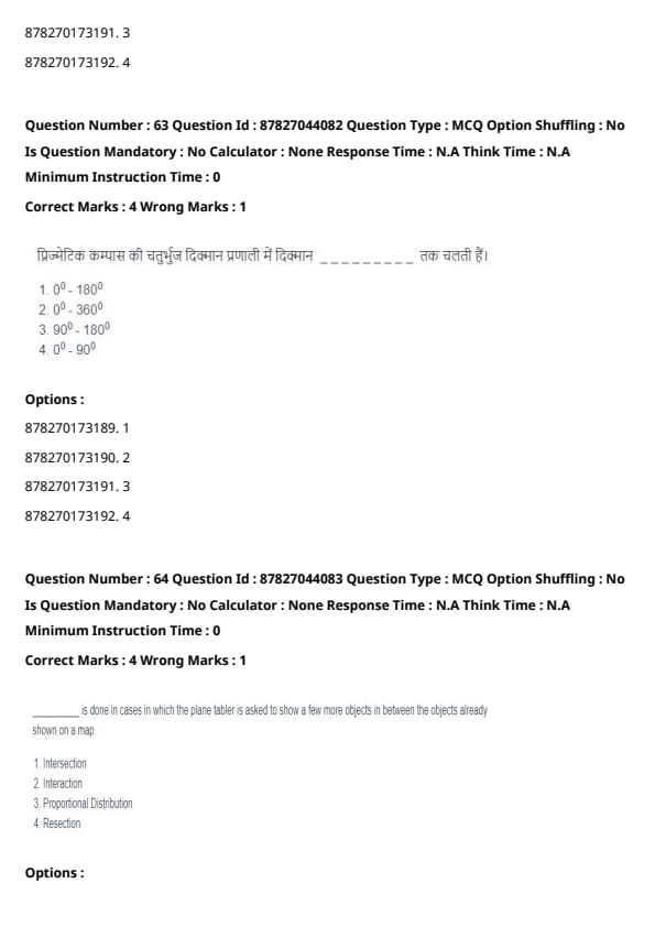
In the Quadrantal bearing system of Prismatic Compass, the bearings run from ______________.
View Solution
In the Quadrantal bearing system used in a Prismatic Compass, bearings are measured from 0° to 180° within the north and south quadrants, providing a limited range for directional readings. Quick Tip: Quadrantal bearings are measured within a restricted range of 0° to 180° for easier directional reference.
______________ is done in cases where the plane tabler is asked to show additional objects between already plotted objects on a map.
View Solution
Resection is a technique in plane table surveying used to determine an unknown point's position by measuring angles from known reference points. Quick Tip: Resection is a common surveying method to determine unknown positions using reference points.
Does your village have piped drinking water supply? This question is an example of which type of statistical measurement scale?
View Solution
The nominal scale is used for categorical data, where responses are classified into distinct categories without any inherent ranking, such as "Yes" or "No" answers. Quick Tip: The nominal scale categorizes data into distinct groups but does not imply any ranking or order.
Which of the following is defined as \[ f(x) = \frac{e^{-m} m^x}{x!} \]
View Solution
The given formula represents the Poisson distribution, which is used to determine the probability of a fixed number of events occurring within a given interval of time or space. It is commonly applied in scenarios such as traffic analysis, system failures, and call center arrivals. Quick Tip: The Poisson distribution models events that occur randomly and independently over time or space.
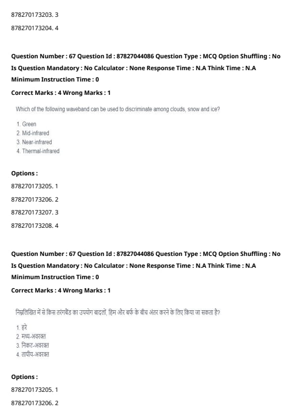
Which of the following wavebands can be used to differentiate among clouds, snow, and ice?
View Solution
The Near-infrared spectrum is used to distinguish between clouds, snow, and ice because snow and ice have high reflectance in this band, while clouds generally do not. This allows effective identification of different surface features. Quick Tip: Near-infrared wavelengths help in differentiating various land and atmospheric features, including vegetation, water, and ice.
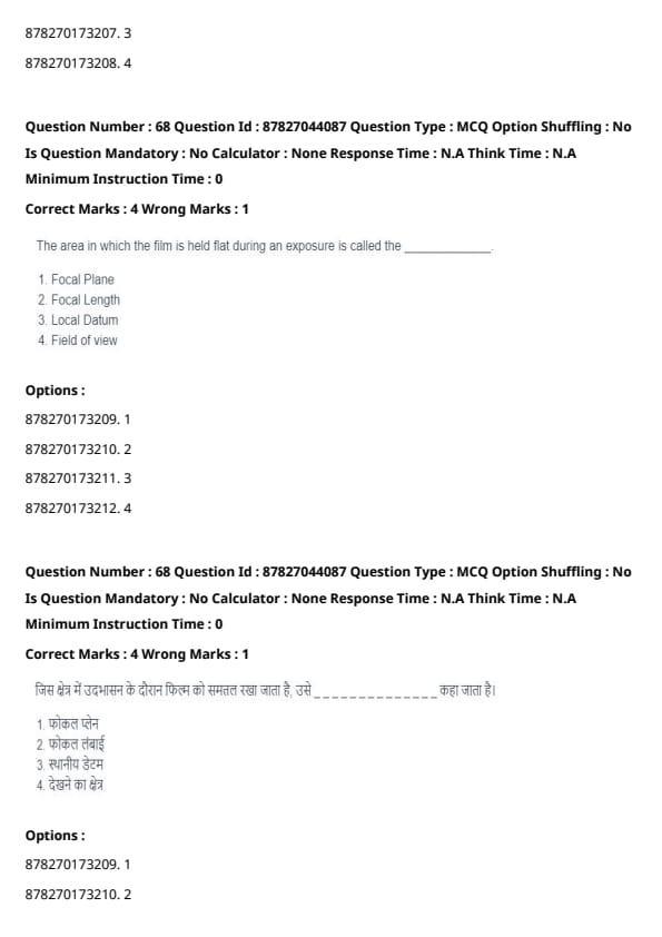
The area where the film remains flat during an exposure is called the _________________.
View Solution
The focal plane refers to the precise area in a camera or surveying instrument where the image is captured sharply during exposure. It ensures that the image remains in proper focus. Quick Tip: The focal plane plays a crucial role in maintaining image sharpness in cameras and surveying instruments.
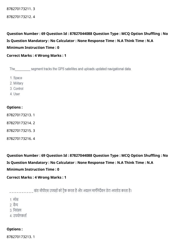
The ______________ segment is responsible for tracking GPS satellites and uploading updated navigational data.
View Solution
The control segment of the GPS system is tasked with tracking satellites, monitoring their positions, and transmitting updated navigational data to ensure accurate global positioning. Quick Tip: The control segment is essential for managing GPS satellite data and maintaining system accuracy.
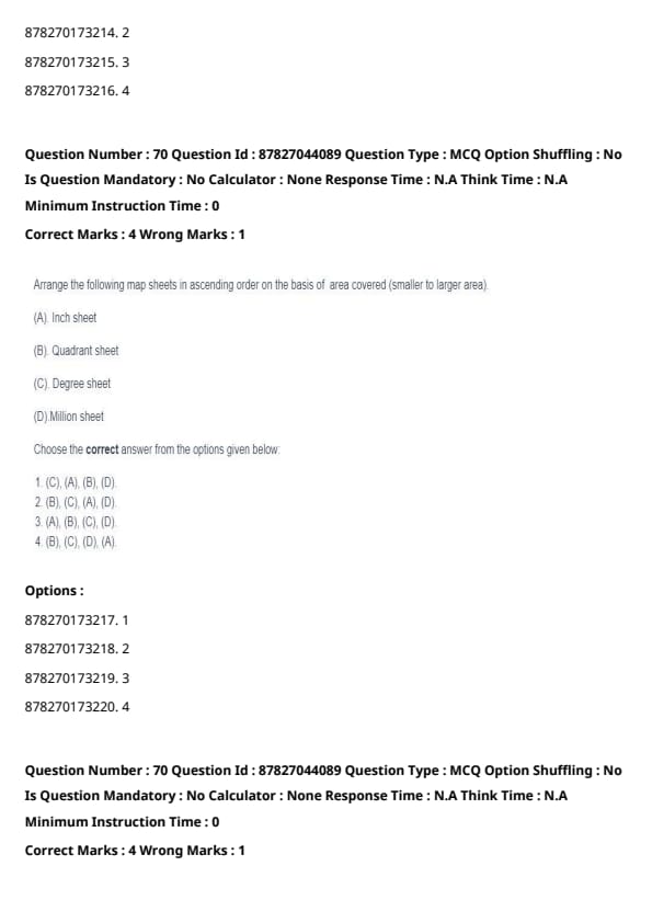
Arrange the following map sheets in ascending order based on the area covered (from smallest to largest).
View Solution
In cartography, different types of map sheets cover varying areas. From smallest to largest, the order is:
- Inch sheet (C) – Covers the smallest area.
- Quadrant sheet (A) – Covers a larger area than the inch sheet.
- Degree sheet (B) – Covers an even broader region.
- Million sheet (D) – Represents the largest coverage.
Thus, the correct order is (C), (A), (B), (D). Quick Tip: The classification of map sheets depends on their coverage, with Million sheets covering the largest area.
Arrange the following cities in descending order based on rainfall variability when mean and standard deviation are provided.
View Solution
To determine the variability, we compute the coefficient of variation (CV), which is given by:
\[ CV = \frac{Standard Deviation}{Mean} \times 100 \]
Now, calculating CV for each city:
\[ CV for (A) = \frac{5}{50} \times 100 = 10% \]
\[ CV for (B) = \frac{10}{150} \times 100 = 6.67% \]
\[ CV for (C) = \frac{5}{20} \times 100 = 25% \]
\[ CV for (D) = \frac{20}{250} \times 100 = 8% \]
Sorting these in descending order:
- (C) CV = 25%
- (A) CV = 10%
- (D) CV = 8%
- (B) CV = 6.67%
Thus, the correct order is (B), (A), (C), (D), matching option (1). Quick Tip: The coefficient of variation (CV) is a measure of relative dispersion. A higher CV means greater variability compared to the mean.
Identify the correct statements regarding aerial photo interpretation.
View Solution
- (A) Correct: Railways appear as dark, thin lines, while highways made of concrete are lighter in aerial photographs due to differences in material reflectance.
- (B) Incorrect: Texture helps identify vegetative cover, but specific crops or pastures are better distinguished by spectral signatures rather than texture alone.
- (C) Correct: The shape of landforms such as hills and valleys aids in interpreting topographical relief.
- (D) Correct: The pattern of drainage features in aerial images reveals information about the geology, structure, and soil type of an area.
Thus, the correct answer is (A), (C), and (D), which corresponds to option (1). Quick Tip: Aerial photo interpretation relies on tone, texture, shape, and pattern to identify land features and geological characteristics.
Identify the correct statements about Chain and Tape Survey.
View Solution
- (A) Correct: Chain and Tape Survey requires only two people – one to handle the chain or tape and another to mark points.
- (B) Incorrect: The statement applies to triangulation surveying rather than Chain and Tape Survey.
- (C) Correct: Kinks in the chain can distort readings, so they must be straightened before taking measurements.
- (D) Incorrect: While smaller triangles increase accuracy, Chain and Tape Survey does not specifically require triangles to be minimized in size.
Thus, the correct choice is (A) and (C), corresponding to option (4). Quick Tip: Always ensure chains are free of kinks and properly aligned in Chain and Tape Survey for accurate results.
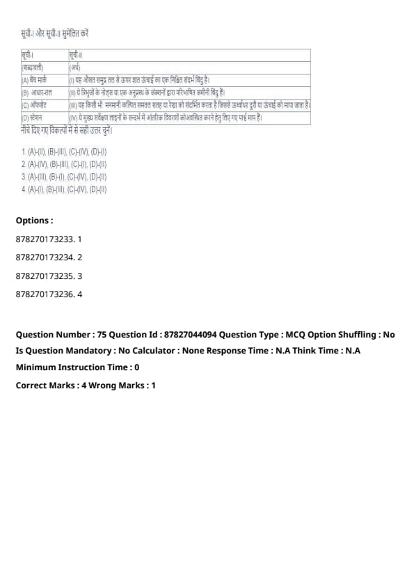
Match List-I with List-II.

Choose the correct answer from the options given below:
View Solution
Let's go through each term and its corresponding meaning:
(A) Bench Mark: This is a fixed reference point of known elevation above mean sea level, corresponding to (I).
(B) Datum: This refers to the ground points defined by the nodes of triangles or junctions of a traverse, corresponding to (II).
(C) Offsets: This refers to any arbitrarily assumed level surface or line from which vertical distances or elevations are measured, corresponding to (III).
(D) Stations: These are lateral measurements taken to locate the interior details with respect to the main survey lines, corresponding to (IV).
Hence, the correct matching is (A) - (II), (B) - (III), (C) - (IV), (D) - (I). Quick Tip: In surveying, understand the basic terminologies like Bench Mark, Datum, Offsets, and Stations to differentiate the types of measurements and reference points used.
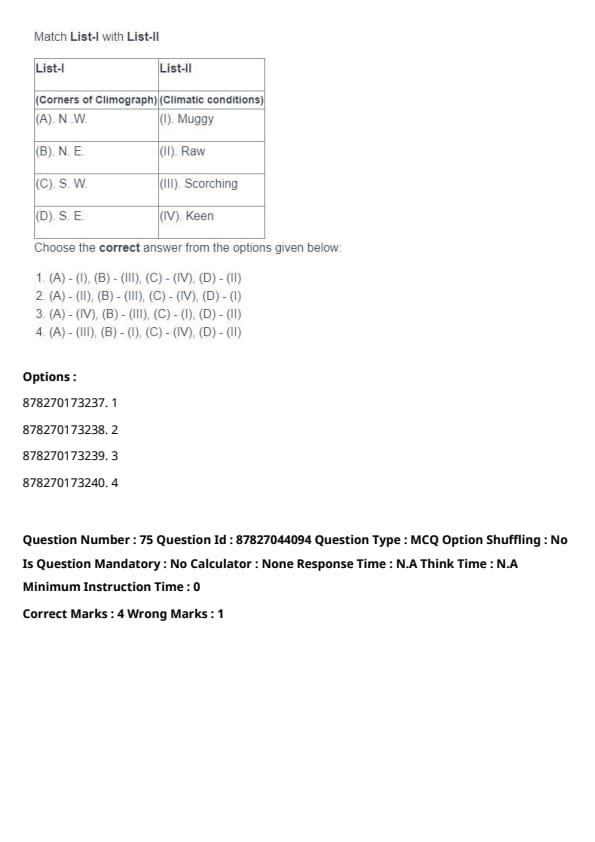
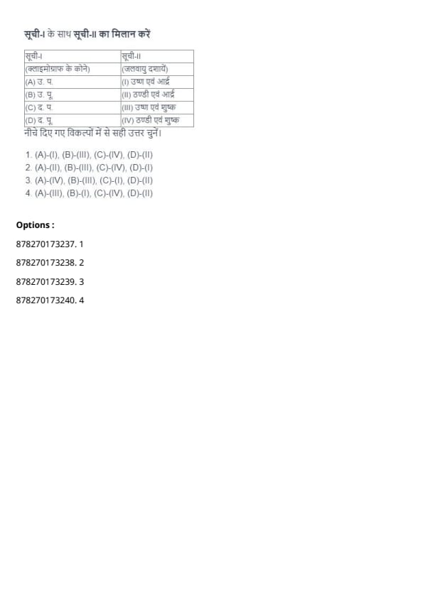
Match List-I with List-II.

Choose the correct answer from the options given below:
View Solution
Let's go through the climatic conditions for each corner of the climograph:
(A) N.W. (North West): This region typically experiences a Keen climate, characterized by dry and cool conditions, matching with (IV).
(B) N.E. (North East): This region generally experiences a Scorching climate, characterized by hot and dry conditions, matching with (III).
(C) S.W. (South West): The South West is typically associated with Raw, warm and humid conditions, matching with (II).
(D) S.E. (South East): This region is usually subject to Muggy, hot and humid conditions, matching with (I).
Hence, the correct matching is (A) - (IV), (B) - (III), (C) - (I), (D) - (II). Quick Tip: To identify climatic conditions, remember that the North West typically has drier and cooler climates, while the South East is known for its humidity.
























































*The article might have information for the previous academic years, please refer the official website of the exam.