
CUET 2024 Question Paper with Solution PDF for Geography (May 17 - Shift 1)


| Updated On - Dec 9, 2024
CUET Question Papers are the most important study material for effective exam preparation. We at Zollege have provided all CUET Previous Year Papers with Solution PDFs here. CUET 2024 Geography was conducted successfully on May 17 by NTA.
Students can freely download the CUET previous year's question paper PDFs along with their solutions here. We strongly encourage cuet aspirants to scan through all the CUET Question Paper to know the overall difficulty level, CUET Syllabus and understand the changes in CUET Exam Pattern over the years.
CUET 2024 Geography Question Paper with Answer Key PDF
| CUET 2024 Geography Question Paper with Answer Key Set A |  Download Download |
Check Solution |
| CUET 2024 Geography Question Paper with Answer Key Set B | Download |
Check Solution |
| CUET 2024 Geography Question Paper with Answer Key Set C | Download |
Check Solution |
| CUET 2024 Geography Question Paper with Answer Key Set D | Download |
Check Solution |
| CUET 2024 Geography Online Question Paper with Answer Key | Download |
Check Solution |
CUET 2024 Geography Question Paper with Solution- SET-A
| Question | Correct Answer | Solution |
|---|---|---|
| Q1:Which of the following is a land-locked harbour? (1) Paradwip port (2) Tuticorin port (3) Haldia port (4) Visakhapatnam port |
(3) Haldia port | Haldia port is a riverine port and is not directly connected to the sea, making it land-locked. |
| Q2:Which of the following ports is confronted with the problem of silt accumulation? (1) Mumbai port (2) New Mangalore port (3) Kolkata port (4) Paradwip port |
(3) Kolkata port | Kolkata port faces severe siltation problems, requiring frequent dredging to maintain navigability. |
| Q3:Where is the headquarters of the ’Organisation of the Petroleum Exporting Countries’ (OPEC)? (1) Montevideo (2) Vienna (3) Minsk (4) Aden |
(2) Vienna | OPEC’s headquarters has been located in Vienna, Austria since 1965. |
| Q4:The General Agreement on Tariffs and Trade (GATT) was transformed into the World Trade Organization in . (1) 1995 (2) 1991 (3) 2005 (4) 1976 |
(1) 1995 | GATT was replaced by the WTO in 1995 after the Uruguay Round of negotiations. |
| Q5:Pykara Hydroelectric Plant was built in . (1) 1929 (2) 1931 (3) 1932 (4) 1942 |
(2) 1931 | The Pykara Hydroelectric Plant, located in Tamil Nadu, was commissioned in 1931. |
| Q6:The total utilisable water resources in India is about cubic km. (1) 4,000 (2) 1,969 (3) 1,869 (4) 1,122 |
(2) 1,969 cubic km | The total utilisable water resources in India are estimated to be about 1,969 cubic kilometers. |
| Q7:The first radio programme was broadcast in India in . (1) 1910 (2) 1913 (3) 1923 (4) 1932 |
(3) 1923 | The first radio broadcast in India occurred in 1923 under the initiative of the Radio Club of Bombay. |
| Q8:Canberra was planned by . (1) Patrick Geddes (2) Walter Burley Griffin (3) Jean Gottmann (4) George Zipf |
(2) Walter Burley Griffin | Canberra was designed by American architect Walter Burley Griffin. |
| Q9:Match List-I with List-II: List-I (Approaches in Human Geography) List-II (Broad features) (A) Areal Differentiation (I) Identifying uniqueness of any region (B) Spatial Organisation (II) Application of quantitative techniques (C) Behavioural School (III) Discontent with quantitative revolution (D) Post-modernism (IV) Focus on local context |
(3) (A) – (I), (B) – (II), (C) – (IV), (D) – (III) | Areal Differentiation identifies uniqueness; Spatial Organisation applies quantitative techniques; Behavioural School focuses on local context; Post-modernism critiques the quantitative approach. |
| Q10:Identify the correct statements about intensive subsistence agriculture dominated by wet paddy cultivation. (A) Small land holdings due to high population density. (B) Farmers work with family labour. (C) Farm yard manure is used. (D) Yield per unit area is low, but productivity per labour is high. |
(3) (A), (B) and (C) only | Intensive subsistence agriculture has small land holdings, relies on family labour, and uses organic fertilizers, but the yield per unit area is typically high. |
| Q11:Arrange the following agricultural regions from equator to pole: (A) Commercial grain farming in the Prairies (B) Reindeer rearing by the Eskimos (C) Tea plantations of north-east India (D) Primitive subsistence farming in Indonesia |
(2) (D), (C), (A), (B) | The order is Primitive subsistence farming in Indonesia (equator), followed by Tea plantations in north-east India, then Commercial grain farming in the Prairies, and Reindeer rearing by the Eskimos (poles). |
| Q12:Arrange the following as per the stages of the demographic transition model: (A) Slow population growth due to high birth and death rates. (B) Fertility remains high, but mortality declines. (C) Fertility declines faster, but mortality declines gradually. (D) Slow population growth due to low birth and death rates. |
(1) (A), (B), (C), (D) | The sequence is high birth and death rates (A), declining mortality but high fertility (B), faster fertility decline (C), and both rates low (D). |
| Q13:Match List-I with List-II: List-I (Station) List-II (Trans-Continental Railway) (A) Chita (I) Australian Trans-Continental Railway (B) Winnipeg (II) Union Pacific Railway (C) Broken Hill (III) Trans-Siberian Railway (D) Chicago (IV) Trans-Canadian Railway |
(2) (A) – (III), (B) – (IV), (C) – (I), (D) – (II) | Chita is on the Trans-Siberian Railway, Winnipeg on the Trans-Canadian Railway, Broken Hill on the Australian railway, and Chicago on the Union Pacific Railway. |
| Q14:Arrange the following copper mines from North to South: (A) Alwar (B) Bhilwara (C) Khetri (D) Udaipur |
(2) (C), (B), (A), (D) | The order is Khetri (North), Bhilwara, Alwar, and Udaipur (South). |
| Q15:Arrange the agricultural development of India in chronological order: (A) Green Revolution (B) Agro-Climatic Planning (C) Intensive Agricultural District Programme (D) National Mission for Sustainable Agriculture |
(1) (C), (A), (B), (D) | Chronological order: Intensive Agricultural District Programme, Green Revolution, Agro-Climatic Planning, National Mission for Sustainable Agriculture. |
| Q16:Match List-I with List-II: List-I (Energy Type) List-II (Key Locations) (A) Nuclear energy (I) Gujarat and Rajasthan (B) Wind energy (II) West Coast of India (C) Tidal energy (III) Tarapur (D) Geothermal energy (IV) Manikaran |
(2) (A) – (III), (B) – (II), (C) – (I), (D) – (IV) | - Nuclear energy is primarily generated at Tarapur. - Wind energy is largely harnessed along the West Coast of India. - Tidal energy projects can be found in Gujarat and Rajasthan. - Geothermal energy is tapped in regions like Manikaran. |
| Q17:Which of the following statements are correct with respect to land degradation? (A) All degraded lands are wasteland. (B) All degraded lands may not be wasteland, but unchecked development may lead to wasteland. (C) Land degradation is a decline in productive capacity. (D) Waterlogged, marshy areas and gullied lands are different types of degraded lands. |
(4) (B), (C) and (D) only | Statement (B) is correct as degraded lands may not always be wasteland; (C) is correct regarding the productive capacity decline; (D) correctly identifies types of degraded lands. |
| Q18:Identify the incorrect statement about the Rhine waterways. (A) It is navigable for 700 km. (B) It flows through a rich coalfield. (C) Ocean-going vessels can reach up to Cologne. (D) It connects the industrial areas of Switzerland, France, and Russia. |
(4) (D) | The Rhine does not connect the industrial areas of Russia; it connects Switzerland, France, Germany, and the Netherlands. |
| Q19:Arrange the following states in descending order of population density as per Census of India, 2011: (A) West Bengal (B) Uttar Pradesh (C) Kerala (D) Tamil Nadu |
(2) (A), (C), (B), (D) | West Bengal has the highest density, followed by Kerala, then Uttar Pradesh, and lastly Tamil Nadu. |
| Q20:Match List-I with List-II: List-I (Type of Town) List-II (Example) (A) Industrial (I) Mhow (B) Commercial (II) Katni (C) Transport (III) Satna (D) Garrison (IV) Modinagar |
(3) (A) – (II), (B) – (I), (C) – (IV), (D) – (III) | Katni is known for its industry; Mhow has commercial significance; Modinagar is a transport hub; Satna is known for its military presence. |
| Q21:Identify the correct statements with reference to the metropolis. (A) It is often the chief centre of some form of activity. (B) It could be an administrative, commercial, or industrial centre. (C) It serves a small hinterland. (D) It is a very large city or agglomeration of population. |
(1) (A), (B) and (D) only | A metropolis is a major center of activity, can serve multiple functions, and is typically a large urban area, not a small hinterland. |
| Q22:Match List-I with List-II: List-I (Economic Activity) List-II (Example) (A) Quaternary (I) Manufacturing (B) Secondary (II) Mining (C) Tertiary (III) Taxi services (D) Primary (IV) Research scientist |
(3) (A) – (IV), (B) – (I), (C) – (III), (D) – (II) | Quaternary activities involve knowledge-based roles; Secondary includes manufacturing; Tertiary covers services like taxi services; Primary relates to extraction such as mining. |
| Q23:Identify the correct statements about oil refineries in India. (A) Digboi is an example of a market-based refinery. (B) Tatipaka Oil Refinery is in Andhra Pradesh. (C) Numaligarh Oil Refinery is in north-east India. (D) Bina Oil Refinery is in Madhya Pradesh. |
(3) (A), (C) and (D) only | Digboi and Numaligarh refineries are significant; Bina is in Madhya Pradesh. However, Tatipaka is a smaller refinery. |
| Q24:Identify the correct statements about transportation in India. (A) Atal Tunnel passes through the Pir Panjal Range. (B) About 80% of the Indian Railway track is metre gauge. (C) The Inland Waterways Authority was set up in 1986. (D) Konkan Railway connects Roha in Karnataka to Mangalore in Kerala. |
(2) (A) and (C) only | The Atal Tunnel does pass through the Pir Panjal Range, and the Inland Waterways Authority was established in 1986; statement (B) is incorrect. |
| Q25:The small-scale manufacturing and cottage manufacturing are distinguished on the basis of . (1) raw materials (2) quantity of production (3) production techniques (4) scale of profits |
(3) production techniques | They are mainly distinguished by their production techniques; cottage industries typically use traditional methods. |
| Q26:Which one of the following is not a feature of small-scale manufacturing? (1) It engages a semi-skilled labour force. (2) It provides employment and raises local purchasing power. (3) The artisans produce goods in their homes with family labour. (4) It is labour intensive manufacturing. |
(3) The artisans produce goods in their homes with family labour. | Small-scale manufacturing typically involves workshops or small factories, rather than home-based production. |
| Q27:From the following, identify the feature of the cottage industry: (1) Use of advanced technology (2) Specialized workers (3) Finished products may be for consumption in the same household. (4) Mass production |
(3) Finished products may be for consumption in the same household. | Cottage industries often produce goods for local consumption, including within the household itself. |
| Q28:Large-scale manufacturing is not . (1) capital intensive (2) energy intensive (3) technology intensive (4) labour intensive |
(4) labour intensive. | Large-scale manufacturing relies more on capital, technology, and energy, rather than manual labour. |
| Q29:Which of the following is not a product of cottage industry? (1) Mat (2) Shoes (3) Car (4) Basket |
(3) Car. | Cottage industries typically produce smaller goods but not large manufactured goods like cars. |
| Q30:Petlawad block of Jhabua is located in which part of the district? (1) Southernmost (2) Westernmost (3) Northernmost (4) Easternmost |
(3) Northernmost. | Petlawad block is located in the northernmost part of the Jhabua district. |
| Q31:Which tribal community has a high concentration in the district of Jhabua? (1) Bhils (2) Munda (3) Santhal (4) Meena |
(1) Bhils. | The Bhils are the dominant tribal community in the Jhabua district. |
| Q32:The Watershed Management Programmes, which have been successfully implemented in Jhabua were funded by . (1) Ministry of Tourism (2) Ministries of Rural Development and Agriculture (3) Ministry of Road Transport and Highways (4) Ministry of Tribal Affairs |
(2) Ministries of Rural Development and Agriculture. | The Watershed Management Programmes were funded by the Ministries of Rural Development and Agriculture. |
| Q33:Which among the following was not used by Bhils to revitalise Common Property Resources? (1) Plantation of fodder grass (2) Plantation of trees (3) Open grazing (4) Social-fencing |
(3) Open grazing. | Bhils revitalised Common Property Resources by preventing open grazing and opting for sustainable practices such as planting fodder grass and trees, as well as implementing social-fencing. Open grazing would undermine their efforts to restore and manage these resources effectively. |
| Q34:Jhabua district is located in which agro-climatic zone of Madhya Pradesh? (1) Northernmost (2) Southernmost (3) Easternmost (4) Westernmost |
(4) Westernmost. | According to the passage, Jhabua is located in the westernmost agro-climatic zone of Madhya Pradesh. |
| Q35:Who defined Human Geography as “Conception resulting from a more synthetic knowledge of the physical laws governing our earth and of the relations between the living beings which inhabit it”? (1) Ratzel (2) Blache (3) Taylor (4) Semple |
(1) Ratzel. | Ratzel is known for his foundational contributions to Human Geography. |
| Q36:“Geography is the study of human beings and environment where nature is supreme that dictates the lifestyle of human beings.” Identify the geographical approach referred to in this statement. (1) Possibilism (2) Environmental Determinism (3) Behaviouralism (4) Humanism |
(2) Environmental Determinism. | This approach emphasizes the influence of natural factors in shaping human behavior. |
| Q37:Which of the following geographers described the ‘state/country’ as a ‘living organism’? (1) French (2) German (3) Australian (4) Indian |
(2) German. | This concept, known as the "organic theory," was introduced by German geographers. |
| Q38:Which of the following country’s population does not have a triangular shaped age-sex pyramid? (1) Australia (2) Bangladesh (3) Nigeria (4) Mexico |
(1) Australia. | Australia’s age-sex pyramid reflects a stable population, unlike developing countries. |
| Q39:Which of the following approaches was initially proposed by the International Labour Organization? (1) Basic needs approach (2) Income approach (3) Capability approach (4) Welfare approach |
(1) Basic needs approach. | The Basic Needs Approach emphasizes providing essential services to improve living standards. |
| Q40:Which of the following is not one of the pillars of Human Development? (1) Equity (2) Affordability (3) Sustainability (4) Empowerment |
(2) Affordability. | Human Development focuses on equity, sustainability, and empowerment. |
| Q41:In which country is milk transported from farms to factories through pipelines? (1) India (2) New Zealand (3) Canada (4) Mexico |
(3) Canada. | Canada uses pipelines for transporting milk to increase efficiency in the dairy industry. |
| Q42:What is the pattern of settlement that develops around a lake? (1) Rectangular pattern (2) Linear pattern (3) T-shaped pattern (4) Circular pattern |
(4) Circular pattern. | Circular settlements commonly form around lakes due to natural geography and access to water. |
| Q43:Which of the following is not a push factor for the migration of the rural population in India? (1) High population pressure on the land (2) Availability of regular work (3) Lack of basic infrastructural facilities (4) Local conflicts |
(2) Availability of regular work. | Availability of regular work is a pull factor, not a push factor, as it attracts people to urban areas. |
| Q44:When and by whom was the first Human Development Report published? (1) WHO in 1992 (2) UNDP in 1992 (3) WHO in 1991 (4) UNDP in 1990 |
(4) UNDP in 1990. | The first Human Development Report was published by the UNDP in 1990. |
| Q45:Among the following, which was the least populated state in 2011? (1) Haryana (2) Tripura (3) Jharkhand (4) Sikkim |
(4) Sikkim. | Sikkim had the smallest population among the given states according to the 2011 Census. |
| Q46:Which of the following States registered the highest population growth rate during 2001–2011? (1) Karnataka (2) Tamil Nadu (3) Rajasthan (4) Maharashtra |
(3) Rajasthan. | Rajasthan recorded the highest population growth rate during the 2001–2011 decade. |
| Q47:Dhani is an example of type of rural settlements. (1) Hamleted (2) Dispersed (3) Semi-clustered (4) Clustered |
(2) Dispersed. | Dhani refers to a type of rural settlement where houses are widely scattered. |
| Q48:Which of the following towns developed as a satellite town? (1) Rohtak (2) Sindri (3) Dispur (4) Mhow |
(4) Mhow. | Mhow is an example of a satellite town, developed to support a nearby larger city. |
| Q49:is an example of ancient towns in India. (1) Madurai (2) Hyderabad (3) Kolkata (4) Delhi |
(1) Madurai. | Madurai is one of the oldest cities in India, known for its ancient history. |
| Q50:‘Boro’, ‘Aman’ and ‘Aus’ are . (1) Tribes found in north-eastern India (2) Types of folk dance (3) Names of rice crops (4) Types of cotton crop |
(3) Names of rice crops. | ‘Boro’, ‘Aman’, and ‘Aus’ are different varieties of rice crops cultivated in India. |
CUET 2024 Geography Question Paper with Solution- SET-B
| Question | Correct Answer | Solution |
|---|---|---|
| Q1: Who, among the following, defined Human Geography as “Conception resulting from a more synthetic knowledge of the physical laws governing our earth and of the relations between the living beings which inhabit it”? (1) Ratzel (2) Blache (3) Taylor (4) Semple |
(1) Ratzel | Friedrich Ratzel, a German geographer, is recognized for defining Human Geography through a focus on the interconnectedness between the physical and human aspects of Earth. |
| Q2: “Geography is the study of human beings and environment where nature is supreme that dictates the lifestyle of human beings.” Identify the geographical approach referred to in this statement. (1) Possibilism (2) Environmental Determinism (3) Behaviouralism (4) Humanism |
(2) Environmental Determinism | Environmental Determinism emphasizes the influence of natural factors in shaping human behavior and societal development. This perspective suggests that humans adapt their lifestyles primarily in response to the environment’s constraints. |
| Q3: Which of the following geographers described the ‘state/country’ as a ‘living organism’? (1) French (2) German (3) Australian (4) Indian |
(2) German | This concept, known as the “organic theory,” was introduced by German geographers, particularly Friedrich Ratzel, who viewed the state as a living entity that requires space and resources to grow. |
| Q4: Which of the following country’s population does not have a triangular-shaped age-sex pyramid? (1) Australia (2) Bangladesh (3) Nigeria (4) Mexico |
(1) Australia | Australia’s age-sex pyramid reflects a more stable or aging population, unlike developing countries like Bangladesh or Nigeria, which exhibit triangular pyramids typical of high birth rates and younger populations. |
| Q5: Which of the following approaches was initially proposed by the International Labour Organization? (1) Basic needs approach (2) Income approach (3) Capability approach (4) Welfare approach |
(1) Basic needs approach | The Basic Needs Approach was proposed by the International Labour Organization (ILO) to emphasize the provision of basic services and goods necessary for human well-being, such as food, shelter, education, and healthcare. |
| Q6: Which of the following is not one of the pillars of Human Development? (1) Equity (2) Affordability (3) Sustainability (4) Empowerment |
(2) Affordability | Human Development focuses on equity, sustainability, and empowerment, but affordability is not considered one of its main pillars. |
| Q7: In which country is milk transported from farms to factories through pipelines? (1) India (2) New Zealand (3) Canada (4) Mexico |
(3) Canada | In certain regions of Canada, milk is transported from farms to factories through pipelines to enhance efficiency in the dairy industry. |
| Q8: What is the pattern of settlement that develops around a lake? (1) Rectangular pattern (2) Linear pattern (3) T-shaped pattern (4) Circular pattern |
(4) Circular pattern | Circular settlements commonly form around lakes due to the natural geography and access to water, providing convenience for settlement layout. |
| Q9: Which of the following is not a push factor for the migration of the rural population in India? (1) High population pressure on the land (2) Availability of regular work (3) Lack of basic infrastructural facilities like health care, education, etc. (4) Local conflicts |
(2) Availability of regular work | Availability of regular work is a pull factor, not a push factor, as it attracts people to urban areas for stable employment opportunities. |
| Q10: When and by whom was the first Human Development Report published? (1) WHO in 1992 (2) UNDP in 1992 (3) WHO in 1991 (4) UNDP in 1990 |
(4) UNDP in 1990 | The first Human Development Report was published by the United Nations Development Programme (UNDP) in 1990, focusing on the concept of human development and introducing the Human Development Index (HDI). |
| Q11: Among the following, which was the least populated state in 2011? (1) Haryana (2) Tripura (3) Jharkhand (4) Sikkim |
(4) Sikkim | As per the 2011 Census, Sikkim was the least populated state in India. The state’s population density and total count were significantly lower compared to other states listed. |
| Q12: Which of the following States registered the highest population growth rate during 2001–2011? (1) Karnataka (2) Tamil Nadu (3) Rajasthan (4) Maharashtra |
(3) Rajasthan | Rajasthan recorded the highest population growth rate among the listed states during the 2001–2011 decade. |
| Q13: Dhani is an example of type of rural settlements. (1) Hamleted (2) Dispersed (3) Semi-clustered (4) Clustered |
(2) Dispersed | Dhani refers to dispersed rural settlements often found in the desert regions where homes and structures are spread apart due to land scarcity and water availability issues. |
| Q14: Which of the following towns developed as a satellite town? (1) Rohtak (2) Sindri (3) Dispur (4) Mhow |
(4) Mhow | Mhow is an example of a satellite town, developed to support a nearby larger city by accommodating population overflow and offering additional resources. |
| Q15: is an example of ancient towns in India. (1) Madurai (2) Hyderabad (3) Kolkata (4) Delhi |
(1) Madurai | Madurai is one of the oldest cities in India, known for its ancient history, temple complexes, and cultural heritage. |
| Q16: ‘Boro’, ‘Aman’ and ‘Aus’ are . (1) Tribes which are found in the north-eastern part of India (2) Types of folk dance (3) Names of rice crops (4) Types of cotton crop |
(3) Names of rice crops | ‘Boro’, ‘Aman’, and ‘Aus’ are different varieties of rice crops cultivated in India, particularly in West Bengal and Bangladesh, with distinct seasonal cycles. |
| Q17: Pykara Hydroelectric Plant was built in . (1) 1921 (2) 1931 (3) 1941 (4) 1951 |
(2) 1931 | The Pykara Hydroelectric Plant, situated in Tamil Nadu, was commissioned in 1931 and is one of India’s earliest hydroelectric projects. |
| Q18: The total utilisable water resources in India is about cubic km. (1) 1,500 cubic km (2) 1,969 cubic km (3) 2,200 cubic km (4) 1,300 cubic km |
(2) 1,969 cubic km | The total utilisable water resources in India are estimated to be around 1,969 cubic kilometers, encompassing both surface water and groundwater resources. |
| Q19: The first radio programme was broadcast in India in . (1) 1921 (2) 1924 (3) 1923 (4) 1927 |
(3) 1923 | The first radio broadcast in India took place in 1923, initiated by the Radio Club of Bombay, marking the beginning of public radio transmission in the country. |
| Q20: Which of the following is a land-locked harbour? (1) Mumbai port (2) Visakhapatnam port (3) Haldia port (4) Chennai port |
(3) Haldia port | Haldia is a riverine port, meaning it is situated inland and relies on river routes for access, making it land-locked as it is not directly connected to the sea. |
| Q21: Which of the following ports is confronted with the problem of silt accumulation? (1) Mumbai port (2) New Mangalore port (3) Kolkata port (4) Paradwip port |
(3) Kolkata port | Due to its location on the Hooghly River, Kolkata port frequently faces silt accumulation, requiring regular dredging to maintain navigability. |
| Q22: Where is the headquarters of the ‘Organisation of the Petroleum Exporting Countries’ (OPEC)? (1) Montevideo (2) Vienna (3) Minsk (4) Aden |
(2) Vienna | Since 1965, OPEC’s headquarters have been located in Vienna, Austria, making it a key location for global oil-related discussions. |
| Q23: The General Agreement on Tariffs and Trade (GATT) was transformed into the World Trade Organization in . (1) 1995 (2) 1991 (3) 2005 (4) 1976 |
(1) 1995 | The GATT was replaced by the World Trade Organization (WTO) in 1995 following the Uruguay Round of trade negotiations, marking a significant shift in international trade regulation. |
| Q24: Canberra was planned by . (1) Patrick Geddes (2) Walter Burley Griffin (3) Jean Gottmann (4) George Zipf |
(2) Walter Burley Griffin | Canberra, the capital city of Australia, was designed by American architect Walter Burley Griffin after winning an international design competition in 1912. |
| Q25: Match List-I with List-II: List-I (Approaches in Human Geography) (A) Areal Differentiation (B) Spatial Organisation (C) Behavioural School (D) Post-modernism List-II (Broad Features) (I) Identifying the uniqueness of any region and understanding how and why it is different (II) Application of quantitative techniques in Geography (III) Discontent with quantitative revolution and its dehumanized manner of doing Geography (IV) Focus on local context Choose the correct answer from the options given below: Options: (1) (A) - (I), (B) - (II), (C) - (III), (D) - (IV) (2) (A) - (I), (B) - (III), (C) - (II), (D) - (IV) (3) (A) - (I), (B) - (II), (C) - (IV), (D) - (III) (4) (A) - (III), (B) - (IV), (C) - (I), (D) - (II) |
(2) (A) - (I), (B) - (III), (C) - (II), (D) - (IV) | The correct matches are: - (A) Areal Differentiation - (I) Identifying the uniqueness of any region and understanding how and why it is different. - (B) Spatial Organisation - (III) Discontent with quantitative revolution and its dehumanized manner of doing Geography. - (C) Behavioural School - (II) Application of quantitative techniques in Geography. - (D) Post-modernism - (IV) Focus on local context. |
| Q26: Identify from the following, the correct statements with reference to the characteristics of intensive subsistence agriculture dominated by wet paddy cultivation: (A) Land holdings are very small due to the high density of population. (B) Farmers work with the help of family labour leading to intensive use of land. (C) Farm yard manure is used to maintain the fertility of the soil. (D) The yield per unit area is low, but productivity per labour is high. Choose the correct answer from the options given below: (1) (A), (B) and (D) only (2) (A), (C) and (D) only (3) (A), (B) and (C) only (4) (B), (C) and (D) only |
(3) (A), (B) and (C) only | In intensive subsistence agriculture, particularly in wet paddy cultivation: - Land holdings are generally very small due to high population density. - Family labour is commonly used, leading to intensive land use. - Organic fertilizers like farmyard manure are applied to maintain soil fertility. Statement (D) is incorrect as the yield per unit area is usually high, but the productivity per labour is relatively lower. |
| Q27: Arrange the following agricultural regions from equator to pole: (A) Commercial grain farming in the Prairies (B) Reindeer rearing by the Eskimos (C) Tea plantations of north-east India (D) Primitive subsistence farming in Indonesia Choose the correct answer from the options given below: (1) (C), (D), (A), (B), (2) (D), (C), (A), (B), (3) (D), (C), (B), (A), (4) (C), (D), (B), (A) |
(2) (D), (C), (A), (B) | The correct order from the equator to the pole would be: - (D) Primitive subsistence farming in Indonesia (near the equator). - (C) Tea plantations of north-east India. - (A) Commercial grain farming in the Prairies. - (B) Reindeer rearing by the Eskimos (closer to the poles). |
| Q28: Arrange the following as per the stages of the demographic transition model: (A) Population growth is slow due to high birth and high death rate. (B) Fertility remains high, but mortality declines at a faster pace. (C) Fertility declines at a faster pace, but mortality declines gradually. (D) Population growth is slow due to low birth and low death rate. Choose the correct answer from the options given below: (1) (A), (B), (C), (D), (2) (A), (C), (B), (D), (3) (D), (B), (C), (A), (4) (D), (C), (B), (A) |
(1) (A), (B), (C), (D) | The demographic transition model follows this sequence: - Stage 1: High birth and high death rates, resulting in slow population growth. - Stage 2: Mortality begins to decline rapidly, while fertility remains high, leading to a rapid population increase. - Stage 3: Fertility declines faster, while mortality continues to decline, resulting in a slower population growth rate. - Stage 4: Both birth and death rates are low, resulting in stable or slow population growth. |
| Q29:Match List-I with List-II: Choose the correct answer from the options given below: List-I (Station) (A) Chita (B) Winnipeg (C) Broken Hill (D) Chicago List-II (Trans-Continental Railway) (I) Australian Trans-Continental Railway (II) Union Pacific Railway (III) Trans-Siberian Railway (IV) Trans-Canadian Railway Options: (1) (A) - (I), (B) - (II), (C) - (III), (D) - (IV) (2) (A) - (III), (B) - (IV), (C) - (I), (D) - (II) (3) (A) - (II), (B) - (I), (C) - (IV), (D) - (III) (4) (A) - (I), (B) - (IV), (C) - (II), (D) - (III) |
(2) (A) - (III), (B) - (IV), (C) - (I), (D) - (II) | The correct matches are: - (A) Chita - (III) Trans-Siberian Railway - (B) Winnipeg - (IV) Trans-Canadian Railway - (C) Broken Hill - (I) Australian Trans-Continental Railway - (D) Chicago - (II) Union Pacific Railway |
| Q30: Arrange the following copper mines in North to South direction: (A) Alwar (B) Bhilwara (C) Khetri (D) Udaipur Choose the correct answer from the options given below: (1) (B), (D), (C), (A), (2) (C), (B), (A), (D), (3) (B), (C), (D), (A), (4) (C), (A), (B), (D) |
(2) (C), (B), (A), (D) | The correct North to South arrangement of these copper mines is: - Khetri (North) - Bhilwara - Alwar - Udaipur (South) |
| Q31: Arrange the agricultural development of India in chronological order from Independence to the present day: (A) Green Revolution (B) Agro-Climatic Planning (C) Intensive Agricultural District Programme (D) National Mission for Sustainable Agriculture Choose the correct answer from the options given below: (1) (C), (A), (B), (D), (2) (B), (C), (D), (A), (3) (B), (A), (D), (C), (4) (D), (A), (C), (B) |
(3) (B), (A), (D), (C) | The chronological order of agricultural developments in India is: 1. Agro-Climatic Planning (B) 2. Green Revolution (A) 3. National Mission for Sustainable Agriculture (D) 4. Intensive Agricultural District Programme (C) |
| Q32:Match List-I with List-II: Choose the correct answer from the options given below: List-I (Energy Type) (A) Nuclear energy (B) Wind energy (C) Tidal energy (D) Geothermal energy List-II (Key Locations/Regions) (I) Gujarat and Rajasthan (II) West Coast of India (III) Tarapur (IV) Manikaran Options: (1) (A) - (I), (B) - (III), (C) - (II), (D) - (IV) (2) (A) - (III), (B) - (I), (C) - (II), (D) - (IV) (3) (A) - (III), (B) - (IV), (C) - (I), (D) - (II) (4) (A) - (II), (B) - (IV), (C) - (III), (D) - (I) |
(2) (A) - (III), (B) - (I), (C) - (II), (D) - (IV) | The correct matches are: - (A) Nuclear energy - Tarapur (III) - (B) Wind energy - Gujarat and Rajasthan (I) - (C) Tidal energy - West Coast of India (II) - (D) Geothermal energy - Manikaran (IV) |
| Q33: Which of the following statements are correct with respect to land degradation? (A) All degraded lands are wastelands. (B) All degraded lands may not be wasteland, but unchecked processes can lead to wasteland. (C) Land degradation is a permanent or temporary decline in productive capacity of the land. (D) Waterlogged, marshy areas, and gullied lands are different types of degraded lands. Choose the correct answer from the options given below: (1) (A), (C) and (D) only (2) (A), (B) and (D) only (3) (A), (B) and (C) only (4) (B), (C) and (D) only |
(4) (B), (C) and (D) only | - Statement (A) is incorrect as not all degraded lands are wastelands. - Statements (B), (C), and (D) accurately describe the characteristics and effects of land degradation. |
| Q34: Identify from the following the statement which is not correct about the Rhine waterways: (1) It is navigable for 700 km. (2) It flows through a rich coalfield and the whole basin has become a prosperous manufacturing area. (3) Ocean-going vessels can reach up to Cologne. (4) It connects the industrial areas of Switzerland, France, and Russia. |
(4) It connects the industrial areas of Switzerland, France, and Russia. | The Rhine waterways connect industrial areas of Switzerland, France, and Germany, not Russia, making statement (4) incorrect. |
| Q35: Arrange the following states in descending order of their population density as per Census of India, 2011: (A) West Bengal (B) Uttar Pradesh (C) Kerala (D) Tamil Nadu Choose the correct answer from the options given below: (1) (D), (A), (C), (B) (2) (A), (C), (B), (D) (3) (B), (A), (D), (C) (4) (C), (B), (D), (A) |
(2) (A), (C), (B), (D) | Population density in descending order is: - West Bengal (A) - Kerala (C) - Uttar Pradesh (B) - Tamil Nadu (D) |
| Q36:Match List-I with List-II: Choose the correct answer from the options given below: List-I (Type of Town) (A) Industrial (B) Commercial (C) Transport (D) Garrison List-II (Example) (I) Mhow (II) Katni (III) Satna (IV) Modinagar Options: (1) (A) - (IV), (B) - (III), (C) - (II), (D) - (I) (2) (A) - (I), (B) - (II), (C) - (IV), (D) - (III) (3) (A) - (I), (B) - (II), (C) - (IV), (D) - (III) (4) (A) - (III), (B) - (IV), (C) - (I), (D) - (II) |
(3) (A) - (I), (B) - (II), (C) - (IV), (D) - (III) | The correct matches are: - (A) Industrial - Mhow (I) - (B) Commercial - Katni (II) - (C) Transport - Modinagar (IV) - (D) Garrison - Satna (III) |
| Q37: Identify from the following, the correct statements with reference to the metropolis: (A) It is often the chief centre or seat of some form of activity. (B) It could be administrative, commercial, or industrial centre. (C) It generally serves a small hinterland. (D) It is a very large city or agglomeration of population. Choose the correct answer from the options given below: (1) (A), (B), and (D) only (2) (A), (C), and (D) only (3) (A), (B), and (C) only (4) (B), (C), and (D) only |
(1) (A), (B), and (D) only | Metropolises are large cities or urban agglomerations that serve as key centres of administrative, commercial, or industrial activity. Statement (C) is incorrect as metropolises serve large hinterlands. |
| Q38: Match List I with List II: Choose the correct answer from the options given below: List-I (Economic Activity) (A) Quaternary (B) Secondary (C) Tertiary (D) Primary List-II (Example) (I) Manufacturing (II) Mining (III) Taxi services (IV) Research scientist Options: (1) (A) - (I), (B) - (II), (C) - (III), (D) - (IV) (2) (A) - (I), (B) - (III), (C) - (II), (D) - (IV) (3) (A) - (IV), (B) - (I), (C) - (III), (D) - (II) (4) (A) - (III), (B) - (IV), (C) - (I), (D) - (II) |
(3) (A) - (IV), (B) - (I), (C) - (III), (D) - (II) | The correct matches are: - (A) Quaternary - Research scientist (IV) - (B) Secondary - Manufacturing (I) - (C) Tertiary - Taxi services (III) - (D) Primary - Mining (II) |
| Q39: Identify from the following, the correct statements with reference to oil refineries in India: (A) Digboi is an example of market-based oil refinery. (B) Tatipaka Oil Refinery is located in Andhra Pradesh. (C) Numaligarh Oil Refinery is located in northeast India. (D) Bina Oil Refinery is located in Madhya Pradesh. Choose the correct answer from the options given below: (1) (A), (B), and (D) only (2) (A), (B), and (C) only (3) (A), (C), and (D) only (4) (B), (C), and (D) only |
(3) (A), (C), and (D) only | - Digboi, located in Assam, is a market-based oil refinery. - Numaligarh Refinery is situated in Assam, northeast India. - Bina Refinery is in Madhya Pradesh. Tatipaka Refinery is incorrectly placed as a market-based refinery. |
| Q40: Identify from the following, the correct statements about transportation in India: (A) Atal Tunnel passes through Pir Panjal Range. (B) About 80(C) The Inland Waterways Authority was set up in 1986. (D) Konkan Railway connects Roha in Karnataka to Mangalore in Kerala. Choose the correct answer from the options given below: (1) (A), (B), and (C) only (2) (A) and (C) only (3) (A) and (B) only (4) (B), (C), and (D) only |
(2) (A) and (C) only | - Atal Tunnel passes through the Pir Panjal Range. - The Inland Waterways Authority was established in 1986. - Statements (B) and (D) are incorrect as the railway network is mostly broad gauge, and Roha is in Maharashtra, not Karnataka. |
| Q41: The small-scale manufacturing and the cottage manufacturing are distinguished on the basis of . (1) Raw materials (2) Quantity of production (3) Production techniques (4) Scale of profits |
(3) Production techniques | Small-scale and cottage industries are distinguished by production techniques. Cottage industries use traditional methods in home-based setups, while small-scale industries use workshops and power-driven machines. |
| Q42: Which one of the following is not a feature of small-scale manufacturing? (1) It engages semi-skilled labour force. (2) It provides employment and raises local purchasing power. (3) The artisans produce goods in their homes with the help of family members. (4) It is labour-intensive manufacturing. |
(3) The artisans produce goods in their homes with the help of family members. | Small-scale manufacturing typically utilizes workshops or small factories rather than home-based production, which is characteristic of cottage industries. |
| Q43: From the following, identify the feature of the cottage industry: (1) Use of advanced technology (2) Specialized workers (3) Finished products may be for consumption in the same household (4) Mass production |
(3) Finished products may be for consumption in the same household. | Cottage industries create goods for local or household use, using simple methods and tools, unlike small-scale or large-scale industries. |
| Q44: Large-scale manufacturing is not . (1) Capital-intensive (2) Energy-intensive (3) Technology-intensive (4) Labour-intensive |
(4) Labour-intensive | Large-scale manufacturing relies on automation, advanced technology, and energy rather than manual labour, making it less labour-intensive compared to smaller industries. |
| Q45: Which of the following is not a product of the cottage industry? (1) Mat (2) Shoes (3) Car (4) Basket |
(3) Car | Cottage industries specialize in producing small, simple goods like mats and baskets. Manufacturing complex products like cars requires advanced technology and large-scale setups. |
| Q46: Petlawad block of Jhabua is located in which part of the district? (1) Southernmost (2) Westernmost (3) Northernmost (4) Easternmost |
(3) Northernmost | The passage states that the Petlawad block is located in the northernmost part of Jhabua district, Madhya Pradesh. |
| Q47: Which tribal community has a high concentration in the district of Jhabua? (1) Bhils (2) Munda (3) Santhal (4) Meena |
(1) Bhils | The Bhils are the dominant tribal community in Jhabua district as per the passage provided. |
| Q48: The Watershed Management Programmes, which have been successfully implemented in Jhabua, were funded by . (1) Ministry of Tourism (2) Ministries of Rural Development and Agriculture (3) Ministry of Road Transport and Highways (4) Ministry of Tribal Affairs |
(2) Ministries of Rural Development and Agriculture | The Watershed Management Programmes in Jhabua were funded by the Ministries of Rural Development and Agriculture, focusing on improving soil quality and preventing degradation. |
| Q49: Which among the following was not used by Bhils to revitalize Common Property Resources? (1) Plantation of fodder grass (2) Plantation of trees (3) Open grazing (4) Social fencing |
(3) Open grazing | The Bhils adopted stall feeding instead of open grazing to preserve pastures and ensure sustainability, as highlighted in the passage. |
| Q50: Jhabua district is located in which agro-climatic zone of Madhya Pradesh? (1) Northernmost (2) Southernmost (3) Easternmost (4) Westernmost |
(4) Westernmost | Jhabua is situated in the westernmost agro-climatic zone of Madhya Pradesh, as clearly mentioned in the passage. |
CUET 2024 Geography Question Paper with Solution- SET-C
| Question | Correct Answer | Solution |
|---|---|---|
| Q1: Match List-I with List-II: Choose the correct answer from the options given below: (1) (A) - (I), (B) - (II), (C) - (III), (D) - (IV) (2) (A) - (III), (B) - (IV), (C) - (I), (D) - (II) (3) (A) - (II), (B) - (I), (C) - (IV), (D) - (III) (4) (A) - (III), (B) - (II), (C) - (IV), (D) - (I) |
(2) (A) - (III), (B) - (IV), (C) - (I), (D) - (II) | Chita corresponds to the Trans-Siberian Railway, Winnipeg to the Trans-Canadian Railway, Broken Hill to the Australian Trans-Continental Railway, and Chicago to the Union Pacific Railway. Each station is associated with its corresponding railway based on location and transport routes. |
| Q2: Arrange the following agricultural regions from equator to pole: (A) Commercial grain farming in the Prairies (B) Reindeer rearing by the Eskimos (C) Tea plantations of north-east India (D) Primitive subsistence farming in Indonesia Choose the correct answer from the options given below: (1) (C), (D), (A), (B) (2) (D), (C), (A), (B) (3) (D), (C), (B), (A) (4) (C), (D), (B), (A) |
(2) (D), (C), (A), (B) | Starting from the equator, Primitive subsistence farming in Indonesia is the closest, followed by Tea plantations of north-east India, Commercial grain farming in the Prairies, and finally Reindeer rearing by the Eskimos near the poles. |
| Q3: Arrange the following as per the stages of the demographic transition model: (A) Population growth is slow due to high birth and high death rate. (B) Fertility remains high, but mortality declines at a faster pace. (C) Fertility declines at a faster pace, but mortality declines gradually. (D) Population growth is slow due to low birth and low death rate. Choose the correct answer from the options given below: (1) (A), (B), (C), (D) (2) (A), (C), (B), (D) (3) (D), (B), (C), (A) (4) (D), (C), (B), (A) |
(1) (A), (B), (C), (D) | The demographic transition model describes the following stages: - Stage 1: High birth and high death rates lead to slow population growth. - Stage 2: Mortality begins to decline faster than fertility, causing population growth to increase. - Stage 3: Fertility declines rapidly, while mortality decreases gradually, slowing population growth. - Stage 4: Both birth and death rates are low, resulting in stable or slow population growth. |
| Q4: Arrange the following copper mines in North to South direction: (A) Alwar (B) Bhilwara (C) Khetri (D) Udaipur |
(C), (B), (A), (D) | The correct order is Khetri in the north, followed by Bhilwara, Alwar, and Udaipur in the south. This sequence is based on their geographic locations. |
| Q5: Arrange the agricultural development of India in chronological order: (A) Green Revolution (B) Agro-Climatic Planning (C) Intensive Agricultural District Programme (D) National Mission for Sustainable Agriculture Choose the correct answer from the options given below: (1) (C), (A), (B), (D) (2) (B), (C), (D), (A) (3) (B), (A), (D), (C) (4) (D), (A), (C), (B) |
(3) (B), (A), (D), (C) | The chronological sequence is: 1. Agro-Climatic Planning 2. Green Revolution 3. National Mission for Sustainable Agriculture 4. Intensive Agricultural District Programme |
| Q6: Match List-I with List-II: Choose the correct answer from the options given below: (1) (A) - (I), (B) - (III), (C) - (II), (D) - (IV) (2) (A) - (III), (B) - (I), (C) - (II), (D) - (IV) (3) (A) - (III), (B) - (IV), (C) - (I), (D) - (II) (4) (A) - (II), (B) - (IV), (C) - (III), (D) - (I) |
(2) (A) - (III), (B) - (I), (C) - (II), (D) - (IV) | Nuclear energy is concentrated in Tarapur, wind energy in Gujarat and Rajasthan, tidal energy along the West Coast, and geothermal energy near Manikaran. |
| Q7: Which of the following statements are correct with respect to land degradation? (A) All degraded lands are wasteland. (B) All degraded lands may not be wasteland, but unchecked development processes may lead to conversion into wasteland. (C) Land degradation is a permanent or temporary decline in productive capacity of the land. (D) Waterlogged, marshy areas, and gullied lands are different types of degraded lands. Choose the correct answer from the options given below: (1) (A), (C) and (D) only (2) (A), (B) and (D) only (3) (A), (B) and (C) only (4) (B), (C) and (D) only |
(4) (B), (C), and (D) only | Statement (A) is incorrect as not all degraded lands are wastelands. Statements (B), (C), and (D) correctly explain the characteristics and effects of land degradation. |
| Q8: Identify from the following the statement which is not correct about the Rhine waterways: 1. It is navigable for 700 km. 2. It flows through a rich coalfield, and the whole basin has become a prosperous manufacturing area. 3. Ocean-going vessels can reach up to Cologne. 4. It connects the industrial areas of Switzerland, France, and Russia. |
(4) It connects the industrial areas of Switzerland, France, and Russia. | The Rhine connects industrial areas of Switzerland, France, and Germany, not Russia. |
| Q9: Arrange the following states in descending order of their population density as per Census of India, 2011: (A) West Bengal (B) Uttar Pradesh (C) Kerala (D) Tamil Nadu Choose the correct answer from the options given below: (1) (D), (A), (C), (B) (2) (A), (C), (B), (D) (3) (B), (A), (D), (C) (4) (C), (B), (D), (A) |
(2) (A), (C), (B), (D) | Population density in descending order is: - West Bengal (A) - Kerala (C) - Uttar Pradesh (B) - Tamil Nadu (D) |
| Q10: Match List-I with List-II: List-I (Type of Town) List-II (Example) (A) Industrial (I) Mhow (B) Commercial (II) Katni (C) Transport (III) Modinagar (D) Garrison (IV) Satna Choose the correct answer from the options given below: (1) (A)-(IV), (B)-(III), (C)-(II), (D)-(I) (2) (A)-(I), (B)-(III), (C)-(II), (D)-(IV) (3) (A)-(I), (B)-(II), (C)-(IV), (D)-(III) (4) (A)-(III), (B)-(IV), (C)-(I), (D)-(II) |
(3) (A)-(I), (B)-(II), (C)-(IV), (D)-(III) | Mhow (Industrial), Katni (Commercial), Modinagar (Transport), Satna (Garrison). |
| Q11: Identify from the following, the correct statements with reference to the metropolis. 1. It is often the chief centre or seat of some form of activity. 2. It could be administrative, commercial or industrial centre. 3. It generally serves a small hinterland. 4. It is a very large city or agglomeration of population. Choose the correct answer from the options given below: (1) (A), (B), and (D) only (2) (A), (B), and (C) only (3) (A), (C), and (D) only (4) (B), (C), and (D) only |
(1) (A), (B), and (D) only | Metropolises are large cities or urban agglomerations that serve as key centres of administrative, commercial, or industrial activity. Statement (C) is incorrect as metropolises serve large hinterlands. |
| Q12: Match List-I with List-II: Choose the correct answer from the options given below: (1) (A) - (I), (B) - (II), (C) - (III), (D) - (IV) (2) (A) - (I), (B) - (III), (C) - (II), (D) - (IV) (3) (A) - (IV), (B) - (I), (C) - (III), (D) - (II) (4) (A) - (III), (B) - (IV), (C) - (I), (D) - (II) |
(3) (A) - (IV), (B) - (I), (C) - (III), (D) - (II) | The correct matches are: (A) Quaternary: Research scientist (IV) (B) Secondary: Manufacturing (I) (C) Tertiary: Taxi services (III) (D) Primary: Mining (II) |
| Q13: Identify from the following, the correct statements with reference to oil refineries in India: (A) Digboi is an example of market-based oil refinery. (B) Tatipaka Oil Refinery is located in Andhra Pradesh. (C) Numaligarh Oil Refinery is located in northeast India. (D) Bina Oil Refinery is located in Madhya Pradesh. Choose the correct answer from the options given below: (1) (A), (B), and (D) only (2) (A), (B), and (C) only (3) (A), (C), and (D) only (4) (B), (C), and (D) only |
(3) (A), (C), and (D) only | Digboi, located in Assam, is a market-based oil refinery. Numaligarh Refinery is situated in Assam, northeast India. Bina Refinery is in Madhya Pradesh. Tatipaka Refinery is incorrectly placed as a market-based refinery. |
| Q14: Identify from the following, the correct statements about transportation in India: (A) Atal Tunnel passes through Pir Panjal Range. (B) About 80% of the railway network is broad gauge. (C) The Inland Waterways Authority was set up in 1986. (D) Konkan Railway connects Roha in Karnataka to Mangalore in Kerala. Choose the correct answer from the options given below: (1) (A), (B), and (C) only (2) (A) and (C) only (3) (A) and (B) only (4) (B), (C), and (D) only |
(2) (A) and (C) only | Atal Tunnel passes through the Pir Panjal Range. The Inland Waterways Authority was established in 1986. Statements (B) and (D) are incorrect as the railway network is mostly broad gauge, and Roha is in Maharashtra, not Karnataka. |
| Q15: The small-scale manufacturing and the cottage manufacturing are distinguished on the basis of: 1. Raw materials 2. Quantity of production 3. Production techniques 4. Scale of profits Correct Answer: (3) Solution: Cottage industries use traditional home-based methods, while small-scale manufacturing involves workshops with power-driven machines. |
(3) | Differentiating industry types is critical for classification questions. |
| Q16: Which one of the following is not a feature of small-scale manufacturing? 1. It engages semi-skilled labour force. 2. It provides employment and raises local purchasing power. 3. The artisans produce goods in their homes with the help of family members. 4. It is labour-intensive manufacturing. Correct Answer: (3) Solution: Small-scale manufacturing is workshop-based, while cottage industries are home-based. |
(3) | Industry features depend on production setup and workforce. |
| Q17: From the following, identify the feature of the cottage industry: 1. Use of advanced technology 2. Specialized workers 3. Finished products may be for consumption in the same household 4. Mass production Correct Answer: (3) Solution: Cottage industries are characterized by traditional, small-scale production for local use. |
(3) | Look for key indicators like traditional methods and local consumption. |
| Q18: Large-scale manufacturing is not: 1. Capital-intensive 2. Energy-intensive 3. Technology-intensive 4. Labour-intensive Correct Answer: (4) Labour-intensive Solution: Large-scale manufacturing relies on automation and efficiency rather than manual labour. |
(4) | Large-scale setups prioritize technology over labour. |
| Q19: Which of the following is not a product of the cottage industry? (1) Mat (2) Shoes (3) Car (4) Basket Correct Answer: (3) Car Solution: Cottage industries specialize in producing small, simple goods like mats and baskets. Manufacturing complex products like cars requires advanced technology and large-scale setups. |
(3) | Cottage industries produce everyday items using traditional methods, not sophisticated manufactured goods. |
| Q20: Petlawad block of Jhabua is located in which part of the district? (1) Southernmost (2) Westernmost (3) Northernmost (4) Easternmost Correct Answer: (3) Northernmost Solution: The passage states that the Petlawad block is located in the northernmost part of Jhabua district, Madhya Pradesh. |
(3) | The Petlawad block is located in the northernmost part of Jhabua district. |
| Q21: Which tribal community has a high concentration in the district of Jhabua? (1) Bhils (2) Munda (3) Santhal (4) Meena |
(1) Bhils | The Bhils are the dominant tribal community in Jhabua district as per the passage provided. |
| Q22: The Watershed Management Programmes, which have been successfully implemented in Jhabua, were funded by: (1) Ministry of Tourism (2) Ministries of Rural Development and Agriculture (3) Ministry of Road Transport and Highways (4) Ministry of Tribal Affairs |
(2) Ministries of Rural Development and Agriculture | The Watershed Management Programmes in Jhabua were funded by the Ministries of Rural Development and Agriculture, focusing on improving soil quality and preventing degradation. |
| Q23: Which among the following was not used by Bhils to revitalize Common Property Resources? (1) Plantation of fodder grass (2) Plantation of trees (3) Open grazing (4) Social fencing |
(3) Open grazing | The Bhils adopted stall feeding instead of open grazing to preserve pastures and ensure sustainability, as highlighted in the passage. |
| Q24: Jhabua district is located in which agro-climatic zone of Madhya Pradesh? (1) Northernmost (2) Southernmost (3) Easternmost (4) Westernmost |
(4) Westernmost | Jhabua is situated in the westernmost agro-climatic zone of Madhya Pradesh, as clearly mentioned in the passage. |
| Q25: Who, among the following, defined Human Geography as “Conception resulting from a more synthetic knowledge of the physical laws governing our earth and of the relations between the living beings which inhabit it”? (1) Ratzel (2) Blache (3) Taylor (4) Semple |
(1) Ratzel | Friedrich Ratzel, a German geographer, is recognized for defining Human Geography through a focus on the interconnectedness between the physical and human aspects of Earth. |
| Q26: “Geography is the study of human beings and environment where nature is supreme that dictates the lifestyle of human beings.” Identify the geographical approach referred to in this statement. (1) Possibilism (2) Environmental Determinism (3) Behaviouralism (4) Humanism |
(2) Environmental Determinism | Environmental Determinism emphasizes the influence of natural factors in shaping human behavior and societal development. This perspective suggests that humans adapt their lifestyles primarily in response to the environment’s constraints. |
| Q27: Which of the following geographers described the ‘state/country’ as a ‘living organism’? (1) French (2) German (3) Australian (4) Indian |
(2) German | This concept, known as the “organic theory,” was introduced by German geographers, particularly Friedrich Ratzel, who viewed the state as a living entity that requires space and resources to grow. |
| Q28: Which of the following country’s population does not have a triangular-shaped age-sex pyramid? (1) Australia (2) Bangladesh (3) Nigeria (4) Mexico |
(1) Australia | Australia’s age-sex pyramid reflects a more stable or aging population, unlike developing countries like Bangladesh or Nigeria, which exhibit triangular pyramids typical of high birth rates and younger populations. |
| Q29: Which of the following approaches was initially proposed by the International Labour Organization? (1) Basic needs approach (2) Income approach (3) Capability approach (4) Welfare approach |
(1) Basic needs approach | The Basic Needs Approach was proposed by the International Labour Organization (ILO) to emphasize the provision of basic services and goods necessary for human well-being, such as food, shelter, education, and healthcare. |
| Q30: Which of the following is not one of the pillars of Human Development? (1) Equity (2) Affordability (3) Sustainability (4) Empowerment |
(2) Affordability | Human Development focuses on equity, sustainability, and empowerment, but affordability is not considered one of its main pillars. |
| Q31: In which country is milk transported from farms to factories through pipelines? (A) India (B) New Zealand (C) Canada (D) Mexico |
(C) Canada | In Canada, pipelines are used in specific regions to transport milk directly from farms to factories, an innovative practice to enhance efficiency in the dairy industry. |
| Q32: What is the pattern of settlement that develops around a lake? (A) Rectangular pattern (B) Linear pattern (C) T-shaped pattern (D) Circular pattern |
(D) Circular pattern | Circular settlements are common around lakes as they offer access to water from all directions, making it convenient for communities. |
| Q33: Which of the following is not a push factor for rural migration in India? (A) High population pressure on the land (B) Availability of regular work (C) Lack of basic infrastructural facilities like health care, education, etc. (D) Local conflicts |
(B) Availability of regular work | Availability of regular work is a pull factor, not a push factor, as it attracts people to urban areas for stable employment opportunities. |
| Q34: When and by whom was the first Human Development Report published? (A) WHO in 1992 (B) UNDP in 1992 (C) WHO in 1991 (D) UNDP in 1990 |
(D) UNDP in 1990 | The first Human Development Report was published by the UNDP in 1990, introducing the Human Development Index (HDI) to focus on human well-being and development. |
| Q35: Among the following, which was the least populated state in Census 2011? (A) Haryana (B) Tripura (C) Jharkhand (D) Sikkim |
(D) Sikkim | Sikkim had the smallest population among the listed states as per the 2011 Census. This is due to its small geographic area and low population density compared to other states. |
| Q36: Which of the following states registered the highest population growth during 2001–2011? (A) Karnataka (B) Tamil Nadu (C) Rajasthan (D) Maharashtra |
(C) Rajasthan | Rajasthan recorded the highest population growth rate during the 2001–2011 period due to rapid urbanization and natural population increase. |
| Q37: Dhani is an example of which type of rural settlement? (A) Hamleted (B) Dispersed (C) Semi-clustered (D) Clustered |
(B) Dispersed | Dhani settlements are found in arid regions like Rajasthan. Homes are widely scattered due to water scarcity and land constraints, making them an example of dispersed settlements. |
| Q38: Which of the following towns developed as a satellite town? (A) Rohtak (B) Sindri (C) Dispur (D) Mhow |
(D) Mhow | Mhow developed as a satellite town to support the urban center of Indore. It provides resources and housing to ease the burden on the main city. |
| Q39: Which of the following is an example of an ancient Indian town? (A) Madurai (B) Hyderabad (C) Kolkata (D) Delhi |
(A) Madurai | Madurai, known for its ancient temples and cultural heritage, is one of the oldest towns in India with a history that dates back thousands of years. |
| Q40: ‘Boro’, ‘Aman’, and ‘Aus’ are: (A) Tribes found in the north-eastern part of India (B) Types of folk dance (C) Names of rice crops (D) Types of cotton crop |
(C) Names of rice crops | ‘Boro’, ‘Aman’, and ‘Aus’ are rice varieties grown in different seasons, particularly in eastern India and Bangladesh. |
| Q41: Pykara Hydroelectric Plant was built in: (A) 1929 (B) 1931 (C) 1932 (D) 1942 |
(B) 1931 | The Pykara Hydroelectric Plant in Tamil Nadu is one of India’s earliest hydroelectric projects, commissioned in 1931. |
| Q42: The total utilisable water resources in India is about: (A) 4,000 cubic km (B) 1,969 cubic km (C) 1,869 cubic km (D) 1,122 cubic km |
(B) 1,969 cubic km | India’s utilisable water resources are estimated at 1,969 cubic kilometers, combining surface and groundwater availability. |
| Q43: The first radio programme was broadcast in India in: (A) 1910 (B) 1913 (C) 1923 (D) 1932 |
(C) 1923 | The first radio programme in India was broadcast in 1923 by the Radio Club of Bombay, marking the start of radio communication. |
| Q44: Which of the following is a land-locked harbour? (A) Paradip port (B) Tuticorin port (C) Haldia port (D) Visakhapatnam port |
(C) Haldia port | Haldia port is a riverine port located inland and relies on river routes, making it land-locked compared to coastal ports. |
| Q45: Which of the following ports is confronted with the problem of silt accumulation? (A) Mumbai port (B) New Mangalore port (C) Kolkata port (D) Paradip port |
(C) Kolkata port | Kolkata port faces silt accumulation due to its location on the Hooghly River, requiring regular dredging to maintain navigability. |
| Q46: Where is the headquarters of the Organisation of the Petroleum Exporting Countries (OPEC)? (A) Montevideo (B) Vienna (C) Minsk (D) Aden |
(B) Vienna | The headquarters of OPEC has been located in Vienna, Austria, since 1965, making it a central hub for global petroleum discussions. |
| Q47: The General Agreement on Tariffs and Trade (GATT) was transformed into the World Trade Organization in: (A) 1995 (B) 1991 (C) 2005 (D) 1976 |
(A) 1995 | The World Trade Organization (WTO) replaced GATT in 1995 after the Uruguay Round of trade negotiations. |
| Q48: Canberra was planned by: (A) Patrick Geddes (B) Walter Burley Griffin (C) Jean Gottmann (D) George Zipf |
(B) Walter Burley Griffin | The Australian capital city, Canberra, was designed by American architect Walter Burley Griffin in 1912 after winning an international competition. |
| Q49: Match List-I with List-II: Choose the correct answer from the options given below: (1) (A) - (I), (B) - (II), (C) - (III), (D) - (IV) (2) (A) - (I), (B) - (III), (C) - (II), (D) - (IV) (3) (A) - (I), (B) - (II), (C) - (IV), (D) - (III) (4) (A) - (III), (B) - (IV), (C) - (I), (D) - (II) |
(2) (A) - (I), (B) - (III), (C) - (II), (D) - (IV) | - (A) Areal Differentiation: Identifies uniqueness of regions. - (B) Spatial Organisation: Applies quantitative techniques. - (C) Behavioural School: Critiques quantitative revolution. - (D) Post-modernism: Focuses on local context. |
| Q50: Identify from the following, the correct statements with reference to the characteristics of intensive subsistence agriculture dominated by wet paddy cultivation: (A) Land holdings are very small due to the high density of population. (B) Farmers work with the help of family labour leading to intensive use of land. (C) Farm yard manure is used to maintain the fertility of the soil. (D) The yield per unit area is low, but productivity per labour is high. Choose the correct answer from the options given below: (1) (A), (B) and (D) only (2) (A), (C) and (D) only (3) (A), (B) and (C) only (4) (B), (C) and (D) only |
(3) (A), (B) and (C) only | In intensive subsistence agriculture, particularly in wet paddy cultivation: - Land holdings are generally very small due to high population density. - Family labour is commonly used, leading to intensive land use. - Organic fertilizers like farmyard manure are applied to maintain soil fertility. Statement (D) is incorrect as the yield per unit area is usually high, but the productivity per labour is relatively lower. |
CUET 2024 Geography Question Paper with Solution- SET-D
| Question | Correct Answer | Solution |
|---|---|---|
| Q1. Identify from the following the correct statements with reference to oil refineries in India. (A) Digboi is an example of market-based oil refinery. (B) Tatipaka Oil Refinery is located in Andhra Pradesh. (C) Numaligarh Oil Refinery is located in northeast India. (D) Bina Oil Refinery is located in Madhya Pradesh. Choose the correct answer from the options given below: (1) (A), (B), and (D) only (2) (A), (B), and (C) only (3) (A), (C), and (D) only (4) (B), (C), and (D) only |
(4) (B), (C) and (D) only | - (B) Andhra Pradesh is home to the Tatipaka Oil Refinery. - (C) Northeastern India is home to the Numaligarh Oil Refinery. - (D) One of India's oldest refineries is the Digboi oil refinery. |
| Q2. Identify from the following the correct statements with reference to the metropolis. (1) It is often the chief centre or seat of some form of activity. (2) It could be an administrative, commercial or industrial centre. (3) It generally serves a small hinterland. (4) It is a very large city or agglomeration of population. Choose the correct answer from the options given below: (1) All of the above (2) 1, 2, and 3 only (3) 2, 3, and 4 only (4) 1 and 2 only |
(1) (A), (B) and (D) only | - (A) A metropolis frequently serves as the main hub or location of an activity. - (B) It might be a commercial, industrial, or administrative hub. - (D) The city or population agglomeration is very large. |
| Q3. Match List-I with List-II: Matching |
(3) (A) – (IV), (B) – (I), (C) – (III), (D) – (II) | - (A) Quaternary (IV): Research scientist - (B) Secondary (I): Manufacturing - (C) Tertiary (III): Taxi services - (D) Primary (II): Mining |
| Q4. Identify from the following, the correct statements about transportation in India. (A) Atal Tunnel passes through Pir Panjal Range. (B) About 80% of India's population lives in rural areas. (C) The Inland Waterways Authority was set up in 1986. (D) Konkan Railway connects Roha in Karnataka to Mangalore in Kerala. Choose the correct answer from the options given below: (1) (A), (B), and (C) only (2) (A) and (C) only (3) (A) and (B) only (4) (B), (C), and (D) only |
(2) (A) and (C) only | - (A) The Atal Tunnel passes through the Pir Panjal Range. This is accurate, as the tunnel is located in Himachal Pradesh beneath the Rohtang Pass. - (B) It is incorrect that 80% of Indian Railway tracks are metre gauge. In fact, most of the tracks are broad gauge, with metre gauge being phased out. - (C) The Inland Waterways Authority was set up in 1986. This is correct, as the IWAI was founded to manage India's inland waterways. - (D) The Konkan Railway connects Mangalore to Roha, but it does so between Karnataka and Maharashtra, not Kerala. |
| Q5. The small scale manufacturing and the cottage manufacturing are distinguished on the basis of _________. 1. Raw materials 2. Quantity of production 3. Production techniques 4. Scale of profits |
(3) production techniques | Small-scale manufacturing typically involves the use of power-driven equipment and semi-skilled labor in workshops, whereas cottage manufacturing is home-based, often involving family labor and simple tools. |
| Q6. Which one of the following is not a feature of small scale manufacturing? 1. It engages semi-skilled labour force. 2. It provides employment and raises local purchasing power. 3. The artisans produce goods in their homes with the help of family members. 4. It is labour-intensive manufacturing. |
(3) The artisans produce goods in their homes with the help of their family members or part-time labor. | Small-scale manufacturing generally takes place in workshops outside homes and uses semi-skilled labor, unlike cottage industries, which are home-based and typically involve family labor. |
| Q7. From the following, identify the feature of the cottage industry: 1. Use of advanced technology 2. Specialized workers 3. Finished products may be for consumption in the same household 4. Mass production |
(3) Finished products may be for consumption in the same household | Cottage industries typically produce goods using simple tools in homes, which may be used domestically or sold in local markets. Unlike small-scale industries, which primarily focus on external markets, cottage industries cater to local or home consumption. |
| Q8. Large scale manufacturing is not ________________. 1. Capital-intensive 2. Energy-intensive 3. Technology-intensive 4. Labour-intensive |
(4) labour intensive | Large-scale manufacturing is characterized by the use of advanced technology and mass production techniques. It is capital- and technology-intensive, rather than labour-intensive, as many tasks are automated or performed by machines. |
| Q9. Which of the following is not a product of cottage industry? (1) Mat (2) Shoes (3) Car (4) Basket |
(3) Car | Products such as carpets, shoes, and baskets are typically made in cottage industries. However, cars are mass-produced in large-scale manufacturing operations requiring specialized labor and advanced technology. |
| Q10. Petlawad block of Jhabua is located in which part of the district? | (3) Northernmost | The Petlawad block is located in the northernmost region of the Jhabua district. It is noted for its successful watershed management and community participation. |
| Q11. Which tribal community has high concentration in the district of Jhabua? (1) Bhils (2) Munda (3) Santhal (4) Meena |
(1) Bhils | The Bhil tribal people have a high concentration in the Jhabua district and are actively involved in community-based initiatives like watershed management. |
| Q12: The Watershed Management Programmes, which have been successfully implemented in Jhabua, were funded by . (1) Ministry of Tourism (2) Ministries of Rural Development and Agriculture (3) Ministry of Road Transport and Highways (4) Ministry of Tribal Affairs |
(2) Ministries of Rural Development and Agriculture | The Watershed Management Programmes in Jhabua were funded by the Ministries of Rural Development and Agriculture, focusing on improving soil quality and preventing degradation. |
| Q13: Which among the following was not used by Bhils to revitalize Common Property Resources? (1) Plantation of fodder grass (2) Plantation of trees (3) Open grazing (4) Social fencing |
(3) Open grazing | The Bhils adopted stall feeding instead of open grazing to preserve pastures and ensure sustainability, as highlighted in the passage. |
| Q14: Jhabua district is located in which agro-climatic zone of Madhya Pradesh? (1) Northernmost (2) Southernmost (3) Easternmost (4) Westernmost |
(4) Westernmost | Jhabua is situated in the westernmost agro-climatic zone of Madhya Pradesh, as clearly mentioned in the passage. |
| Q15: Who, among the following, defined Human Geography as “Conception resulting from a more synthetic knowledge of the physical laws governing our earth and of the relations between the living beings which inhabit it”? (1) Ratzel (2) Blache (3) Taylor (4) Semple |
(1) Ratzel | Friedrich Ratzel, a German geographer, is recognized for defining Human Geography through a focus on the interconnectedness between the physical and human aspects of Earth. |
| Q16: “Geography is the study of human beings and environment where nature is supreme that dictates the lifestyle of human beings.” Identify the geographical approach referred to in this statement. (1) Possibilism (2) Environmental Determinism (3) Behaviouralism (4) Humanism |
(2) Environmental Determinism | Environmental Determinism emphasizes the influence of natural factors in shaping human behavior and societal development. This perspective suggests that humans adapt their lifestyles primarily in response to the environment’s constraints. |
| Q17: Which of the following geographers described the ‘state/country’ as a ‘living organism’? (1) French (2) German (3) Australian (4) Indian |
(2) German | This concept, known as the “organic theory,” was introduced by German geographers, particularly Friedrich Ratzel, who viewed the state as a living entity that requires space and resources to grow. |
| Q18: Which of the following country’s population does not have a triangular-shaped age-sex pyramid? (1) Australia (2) Bangladesh (3) Nigeria (4) Mexico |
(1) Australia | Australia’s age-sex pyramid reflects a more stable or aging population, unlike developing countries like Bangladesh or Nigeria, which exhibit triangular pyramids typical of high birth rates and younger populations. |
| Q19: Which of the following approaches was initially proposed by the International Labour Organization? (1) Basic needs approach (2) Income approach (3) Capability approach (4) Welfare approach |
(1) Basic needs approach | The Basic Needs Approach was proposed by the International Labour Organization (ILO) to emphasize the provision of basic services and goods necessary for human well-being, such as food, shelter, education, and healthcare. |
| Q20: Which of the following is not one of the pillars of Human Development? (1) Equity (2) Affordability (3) Sustainability (4) Empowerment |
(2) Affordability | Human Development focuses on equity, sustainability, and empowerment, but affordability is not considered one of its main pillars. |
| Q21: In which country is milk transported from farms to factories through pipelines? (1) India (2) New Zealand (3) Canada (4) Mexico |
(3) Canada | In Canada, pipelines are used in specific regions to transport milk directly from farms to factories, an innovative practice to enhance efficiency in the dairy industry. |
| Q22: What is the pattern of settlement that develops around a lake? (1) Rectangular pattern (2) Linear pattern (3) T-shaped pattern (4) Circular pattern |
(4) Circular pattern | Circular settlements are common around lakes as they offer access to water from all directions, making it convenient for communities. |
| Q23: Which of the following is not a push factor for rural migration in India? (1) High population pressure on the land (2) Availability of regular work (3) Lack of basic infrastructural facilities like health care, education, etc. (4) Local conflicts |
(2) Availability of regular work | Availability of regular work is a pull factor, not a push factor, as it attracts people to urban areas for stable employment opportunities. |
| Q24: When and by whom was the first Human Development Report published? (1) WHO in 1992 (2) UNDP in 1992 (3) WHO in 1991 (4) UNDP in 1990 |
(4) UNDP in 1990 | The first Human Development Report was published by the UNDP in 1990, introducing the Human Development Index (HDI) to focus on human well-being and development. |
| Q25: Among the following, which was the least populated state in Census 2011? (1) Haryana (2) Tripura (3) Jharkhand (4) Sikkim |
(4) Sikkim | Sikkim had the smallest population among the listed states as per the 2011 Census. This is due to its small geographic area and low population density compared to other states. |
| Q26: Which of the following states registered the highest population growth during 2001–2011? (1) Karnataka (2) Tamil Nadu (3) Rajasthan (4) Maharashtra |
(3) Rajasthan | Rajasthan recorded the highest population growth rate during the 2001–2011 period due to rapid urbanization and natural population increase. |
| Q27: Dhani is an example of which type of rural settlement? (1) Hamleted (2) Dispersed (3) Semi-clustered (4) Clustered |
(2) Dispersed | Dhani settlements are found in arid regions like Rajasthan. Homes are widely scattered due to water scarcity and land constraints, making them an example of dispersed settlements. |
| Q28: Which of the following towns developed as a satellite town? (1) Rohtak (2) Sindri (3) Dispur (4) Mhow |
(4) Mhow | Mhow developed as a satellite town to support the urban center of Indore. It provides resources and housing to ease the burden on the main city. |
| Q29: Which of the following is an example of an ancient Indian town? (1) Madurai (2) Hyderabad (3) Kolkata (4) Delhi |
(1) Madurai | Madurai, known for its ancient temples and cultural heritage, is one of the oldest towns in India with a history that dates back thousands of years. |
| Q30: ‘Boro’, ‘Aman’, and ‘Aus’ are: (1) Tribes found in the north-eastern part of India (2) Types of folk dance (3) Names of rice crops (4) Types of cotton crop |
(3) Names of rice crops | ‘Boro’, ‘Aman’, and ‘Aus’ are rice varieties grown in different seasons, particularly in eastern India and Bangladesh. |
| Q31: Pykara Hydroelectric Plant was built in: (1) 1929 (2) 1931 (3) 1932 (4) 1942 |
(2) 1931 | The Pykara Hydroelectric Plant in Tamil Nadu is one of India’s earliest hydroelectric projects, commissioned in 1931. |
| Q32: The total utilisable water resources in India is about: (1) 4,000 cubic km (2) 1,969 cubic km (3) 1,869 cubic km (4) 1,122 cubic km |
(2) 1,969 cubic km | India’s utilisable water resources are estimated at 1,969 cubic kilometers, combining surface and groundwater availability. |
| Q33: The first radio programme was broadcast in India in: (1) 1910 (2) 1913 (3) 1923 (4) 1932 |
(3) 1923 | The first radio programme in India was broadcast in 1923 by the Radio Club. |
| Q34: Which of the following is a land-locked harbour? (A) Mumbai port (B) Chennai port (C) Haldia port (D) Kolkata port |
(C) Haldia port | Haldia port is a riverine port located inland and relies on river routes, making it land-locked compared to coastal ports. |
| Q35: Which of the following ports is confronted with the problem of silt accumulation? (A) Mumbai port (B) Chennai port (C) Kolkata port (D) Haldia port |
(C) Kolkata port | Kolkata port faces silt accumulation due to its location on the Hooghly River, requiring regular dredging to maintain navigability. |
| Q36: Where is the headquarters of the Organisation of the Petroleum Exporting Countries (OPEC)? (A) Geneva (B) Vienna (C) Paris (D) London |
(B) Vienna | The headquarters of OPEC has been located in Vienna, Austria, since 1965, making it a central hub for global petroleum discussions. |
| Q37: The General Agreement on Tariffs and Trade (GATT) was transformed into the World Trade Organization in: (A) 1995 (B) 1990 (C) 2000 (D) 1985 |
(A) 1995 | The World Trade Organization (WTO) replaced GATT in 1995 after the Uruguay Round of trade negotiations. |
| Q38: Canberra was planned by: (A) Le Corbusier (B) Walter Burley Griffin (C) Frank Lloyd Wright (D) Kenzo Tange |
(B) Walter Burley Griffin | The Australian capital city, Canberra, was designed by American architect Walter Burley Griffin in 1912 after winning an international competition. |
| Q39: Match List-I with List-II: List-I: (A) Areal Differentiation (B) Spatial Organisation (C) Behavioural School (D) Post-modernism List-II: (I) Emphasis on local context (II) Critique of the quantitative revolution (III) Focus on uniqueness of regions (IV) Application of quantitative techniques |
(2) (A) - (I), (B) - (III), (C) - (II), (D) - (IV) | - (A) Areal Differentiation: Identifies uniqueness of regions. - (B) Spatial Organisation: Applies quantitative techniques. - (C) Behavioural School: Critiques quantitative revolution. - (D) Post-modernism: Focuses on local context. |
| Q40: Identify from the following, the correct statements with reference to the characteristics of intensive subsistence agriculture dominated by wet paddy cultivation: (A) Land holdings are generally large. (B) Family labour is commonly used. (C) Fertilizers such as farmyard manure are used. (D) Mechanized tools are widely used. |
(3) (A), (B) and (C) only | In intensive subsistence agriculture, particularly in wet paddy cultivation: - Land holdings are generally very small due to high population density. - Family labour is commonly used, leading to intensive land use. - Organic fertilizers like farmyard manure are applied to maintain soil fertility. |
| Q41: Arrange the following agricultural regions from equator to pole: (A) Primitive subsistence farming of Indonesia (B) Commercial grain farming of Prairies (C) Tea plantations of north-east India (D) Reindeer rearing of Eskimos |
(2) (D), (C), (A), (B) | Starting from the equator, Primitive subsistence farming in Indonesia is the closest, followed by Tea plantations of north-east India, Commercial grain farming in the Prairies, and finally Reindeer rearing by the Eskimos near the poles. |
| Q42: Arrange the following as per the stages of the demographic transition model: (A) High birth and high death rates (B) Decline in death rate, followed by a rise in population (C) Birth rate decreases, population growth slows (D) Both birth and death rates are low |
(1) (A), (B), (C), (D) | The demographic transition model describes the following stages: - Stage 1: High birth and high death rates lead to slow population growth. - Stage 2: Mortality begins to decline faster than fertility, causing population growth to increase. - Stage 3: Fertility declines rapidly, while mortality decreases gradually, slowing population growth. - Stage 4: Both birth and death rates are low, resulting in stable or slow population growth. |
| Q43: Match List-I with List-II: List-I: (A) Chita (B) Winnipeg (C) Broken Hill (D) Chicago List-II: (I) Trans-Siberian Railway (II) Trans-Canadian Railway (III) Union Pacific Railway (IV) Australian Trans-Continental Railway |
(2) (A) - (III), (B) - (IV), (C) - (I), (D) - (II) | Chita corresponds to the Trans-Siberian Railway, Winnipeg to the Trans-Canadian Railway, Broken Hill to the Australian Trans-Continental Railway, and Chicago to the Union Pacific Railway. Each station is associated with its corresponding railway based on location and transport routes. |
| Q44: Arrange the following copper mines in North to South direction: (A) Khetri (B) Bhilwara (C) Alwar (D) Udaipur |
(C), (B), (A), (D) | The correct order is Khetri in the north, followed by Bhilwara, Alwar, and Udaipur in the south. This sequence is based on their geographic locations. |
| Q45: Arrange the agricultural development of India in chronological order: (A) Green Revolution (B) Agro-Climatic Planning (C) National Mission for Sustainable Agriculture (D) Intensive Agricultural District Programme |
(3) (B), (A), (D), (C) | The chronological sequence is: 1. Agro-Climatic Planning 2. Green Revolution 3. National Mission for Sustainable Agriculture 4. Intensive Agricultural District Programme |
| Q46: Match List-I with List-II: List-I: (A) Tarapur (B) Gujarat and Rajasthan (C) West Coast of India (D) Manikaran List-II: (I) Nuclear energy (II) Wind energy (III) Tidal energy (IV) Geothermal energy |
(2) (A) - (III), (B) - (I), (C) - (II), (D) - (IV) | Nuclear energy is concentrated in Tarapur, wind energy in Gujarat and Rajasthan, tidal energy along the West Coast, and geothermal energy near Manikaran. |
| Q47: Which of the following statements are correct with respect to land degradation? (A) All degraded lands are wasteland. (B) All degraded lands may not be wasteland, but unchecked development processes may lead to conversion into wasteland. (C) Land degradation is a permanent or temporary decline in productive capacity of the land. (D) Waterlogged, marshy areas, and gullied lands are different types of degraded lands. Choose the correct answer from the options given below: (1) (A), (C) and (D) only (2) (A), (B) and (D) only (3) (A), (B) and (C) only (4) (B), (C) and (D) only |
(4) (B), (C) and (D) only | Statement (A) is incorrect as not all degraded lands are wastelands. Statements (B), (C), and (D) correctly explain the characteristics and effects of land degradation. |
| Q48: Identify from the following the statement which is not correct about the Rhine waterways. 1. It is navigable for 700 km. 2. It flows through a rich coalfield, and the whole basin has become a prosperous manufacturing area. 3. Ocean-going vessels can reach up to Cologne. 4. It connects the industrial areas of Switzerland, France, and Russia. |
(4) It connects the industrial areas of Switzerland, France, and Russia. | The Rhine connects industrial areas of Switzerland, France, and Germany, not Russia. |
| Q49: Arrange the following states in descending order of their population density as per Census of India, 2011: (A) West Bengal (B) Uttar Pradesh (C) Kerala (D) Tamil Nadu Choose the correct answer from the options given below: (1) (D), (A), (C), (B) (2) (A), (C), (B), (D) (3) (B), (A), (D), (C) (4) (C), (B), (D), (A) |
(2) (A), (C), (B), (D) | Population density in descending order is: West Bengal (A), Kerala (C), Uttar Pradesh (B), Tamil Nadu (D). |
| Q50: Match List-I with List-II: List-I (Type of Town) List-II (Example) (A) Industrial (B) Commercial (C) Transport (D) Garrison (I) Mhow (II) Katni (III) Modinagar (IV) Satna |
(3) (A)-(I), (B)-(II), (C)-(IV), (D)-(III) | Mhow (Industrial), Katni (Commercial), Modinagar (Transport), Satna (Garrison). |

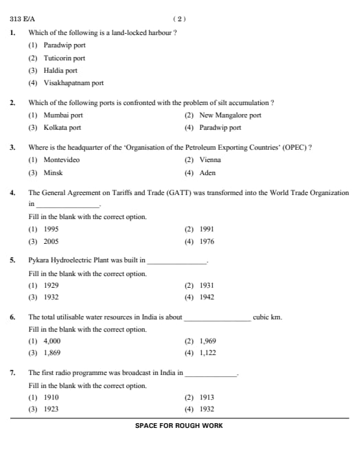
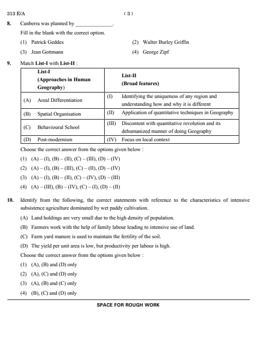
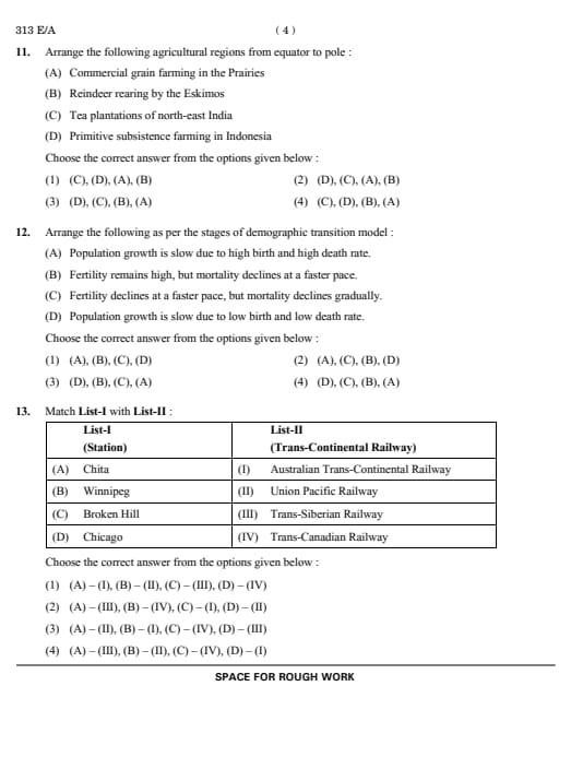
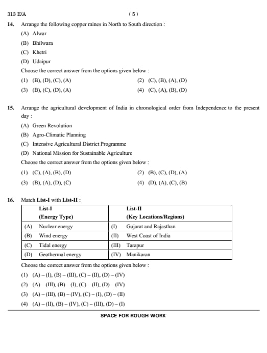
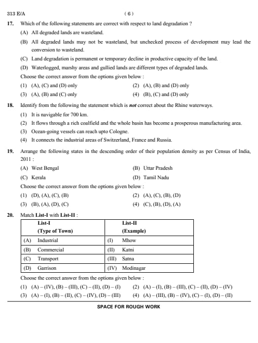
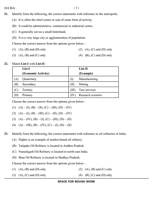
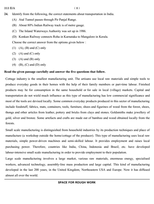
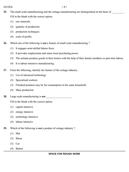
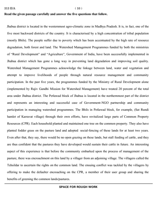
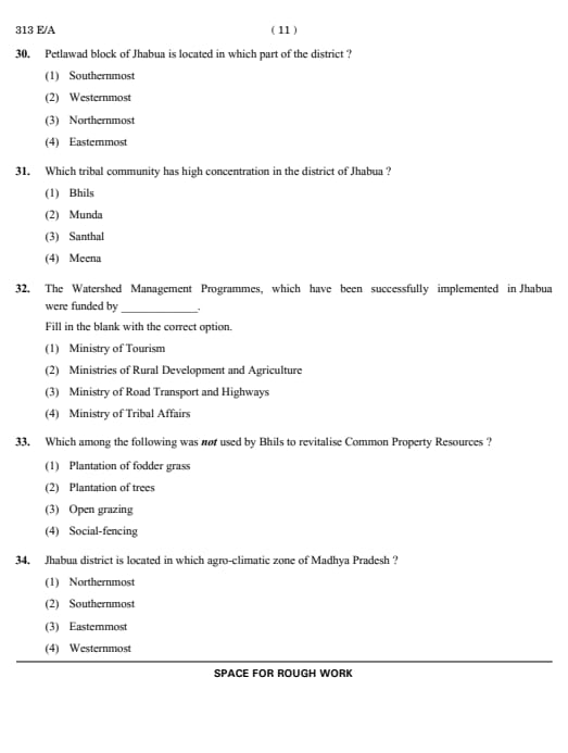
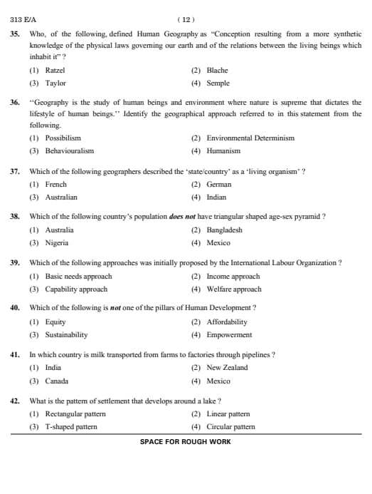
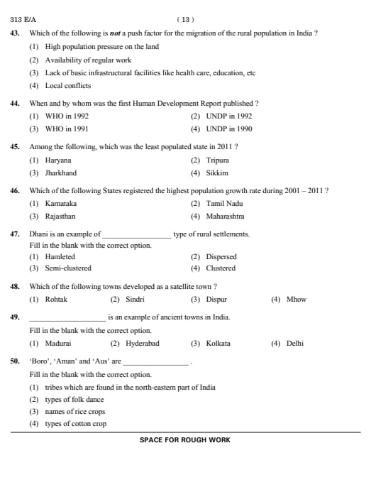





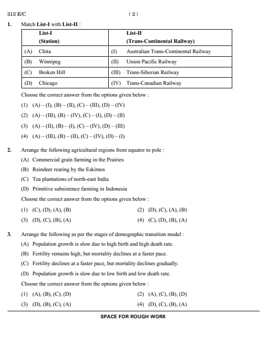
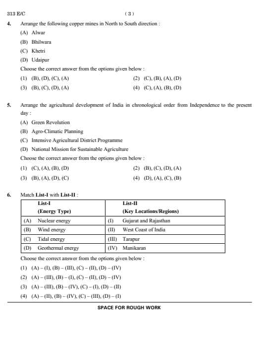
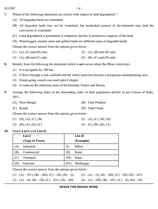
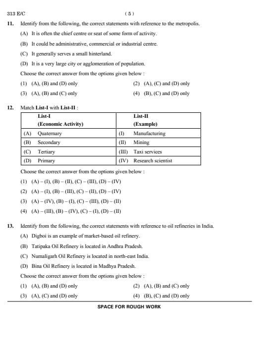
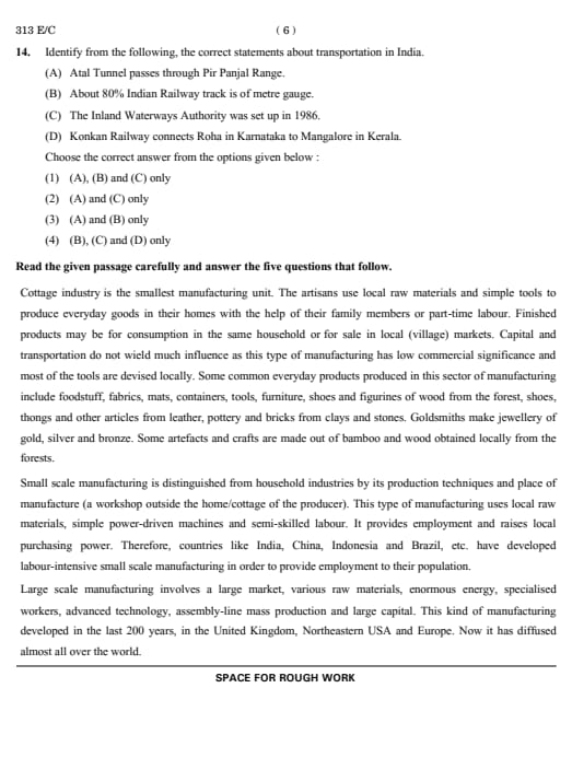
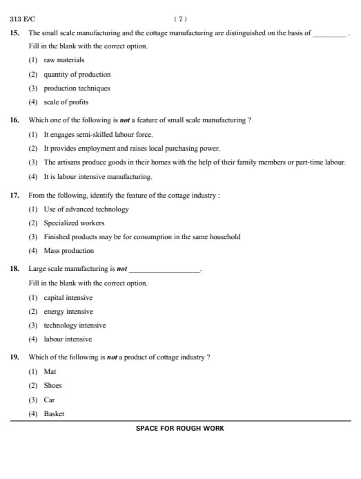
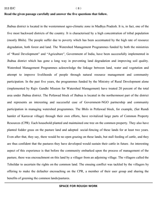
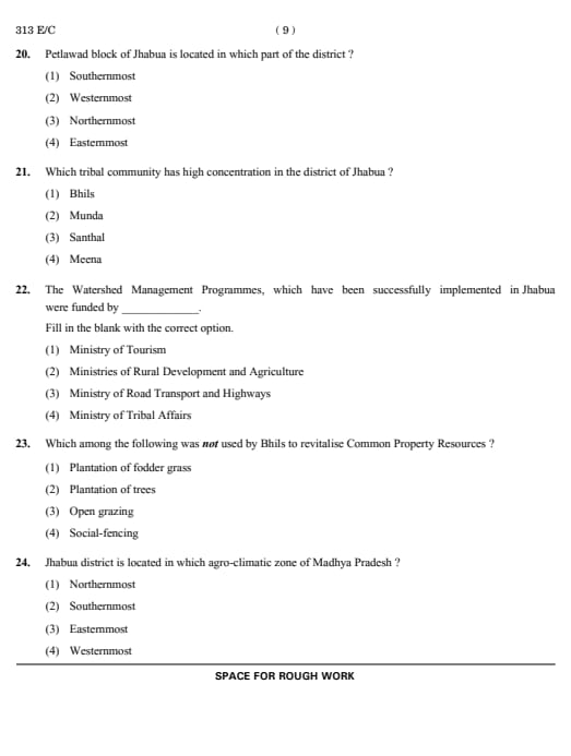
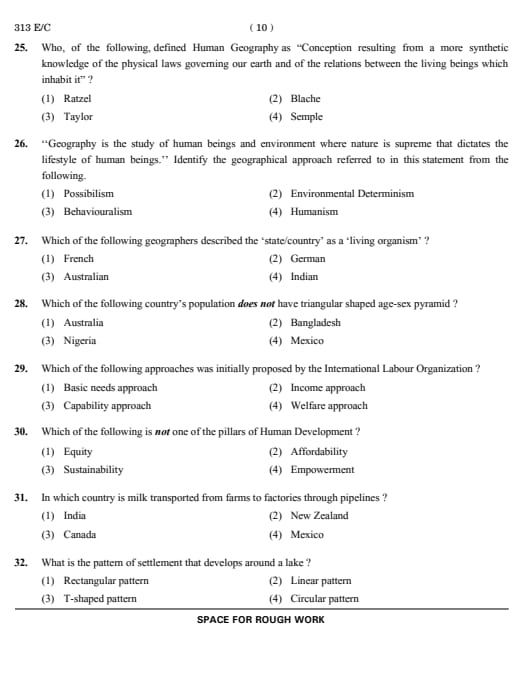
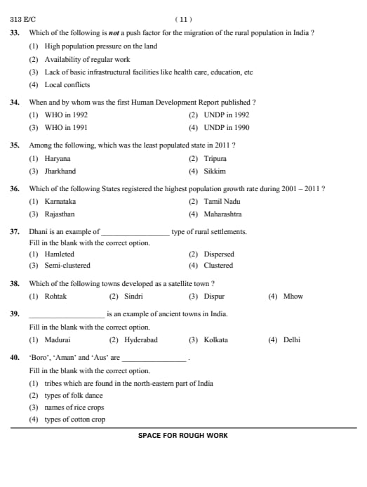
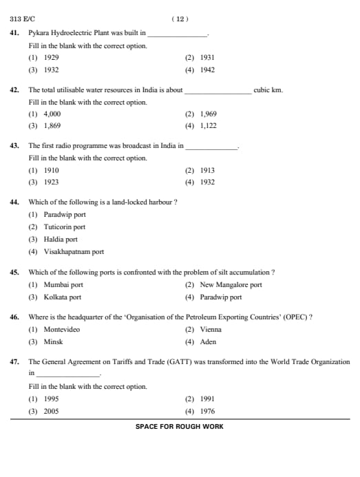
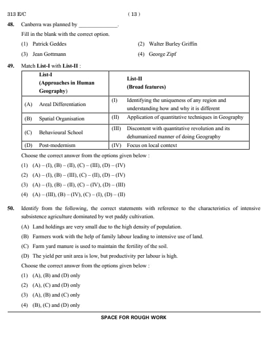




*The article might have information for the previous academic years, please refer the official website of the exam.