.jpg?tr=h-55,w-55,c-force)
UP Board Class 12 Geography Question Paper 2024 (Code 322) is available for download. UPMSP conducted the exam successfully on March 5, 2024, from 2:00 PM to 5:15 PM in pen-paper mode. As per the students’ initial reaction, UP Board 12th Geography Question Paper 2024 was reported as easy to moderate. The Physical Geography section was reported as moderate, the Human Geography section was easy to moderate, and the Practical Geography section was considered moderate by most students.
UP Board Class 12 Geography 2024 Question Paper with Answer Key PDF (Code 322 (EJ)
Candidates can download the UP Board Class 12 Geography Question Paper with Answer Key PDFs (Code 322 (EJ)) using the link below.
| UP Board Class 12 Geography 2024 Question Paper with Answer Key (Code 322 (EJ) |  Download Download |
Check Solution |
UP Board Class 12 Geography Question Paper with Solutions (Code 322 (EJ)
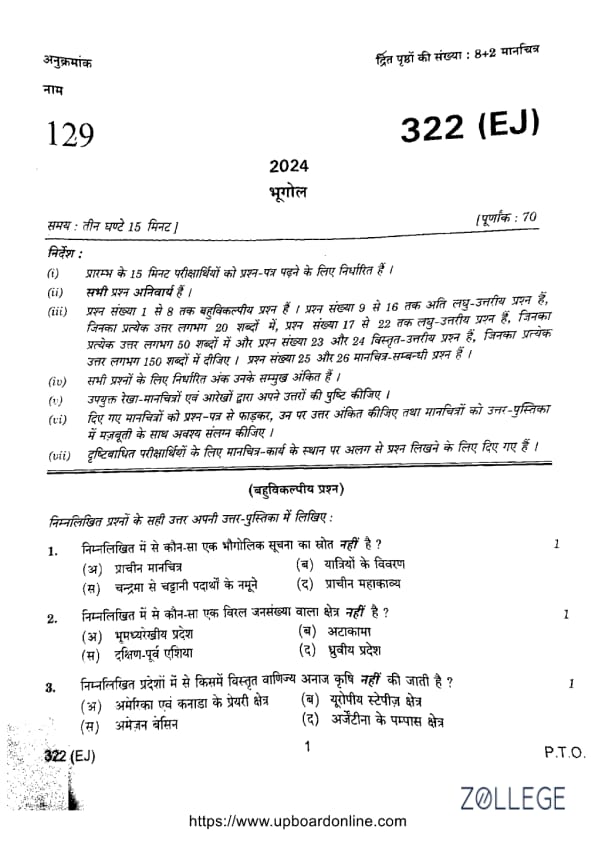
Question 1:
Which of the following is not a source of geographical information?
Correct Answer: (C) Names of minerals from the moon
View Solution
Step 1: Names of minerals from the moon do not serve as a source of geographical information as they are unrelated to Earth’s geography.
Step 2: Ancient maps, descriptions by travelers, and scriptures provide valuable geographical insights.
Question 2:
Which of the following is not a densely populated area?
Correct Answer: (D) Polar regions
View Solution
Step 1: South-East Asia is known for its high population density.
Step 2: The Polar regions and the Thar Desert are sparsely populated due to extreme climatic conditions and limited resources.
Question 3:
In which of the following regions is extensive commercial grain farming not practiced?
Correct Answer: (D) Amazon Basin
View Solution
Step 1: The Amazon Basin is a tropical rainforest region unsuitable for extensive commercial grain farming.
Step 2: Due to dense forests and high rainfall, agriculture is limited in this area.
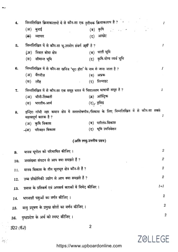
Question 4:
Which of the following is a tertiary activity?
Correct Answer: (C) Trade
View Solution
Step 1: Trade is a tertiary activity because it involves the distribution and exchange of goods and services.
Step 2: Unlike primary (agriculture) and secondary (weaving) activities, tertiary activities focus on services.
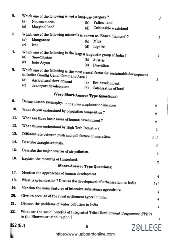
Question 5:
Which one of the following is not a land-use category?
Correct Answer: (C) Marginal land
View Solution
Step 1: Marginal land is not classified as a formal land-use category.
Step 2: Land-use categories typically include net sown area, fallow land, and culturable wasteland.
Question 6:
Which one of the following minerals is known as 'Brown diamond'?
Correct Answer: (D) Lignite
View Solution
Step 1: Lignite, a type of coal, is often referred to as 'Brown diamond' due to its brownish appearance.
Step 2: It is used for energy production due to its economic value.
Question 7:
Which one of the following is the largest linguistic group of India?
Correct Answer: (C) Indo-Aryan
View Solution
Step 1: Indo-Aryan is the largest linguistic group in India, including languages like Hindi, Bengali, and Marathi.
Step 2: These languages are spoken by a majority of the Indian population.
Question 8:
Which one of the following is the most crucial factor for sustainable development in the Indira Gandhi Canal Command Area?
Correct Answer: (B) Eco-development
View Solution
Step 1: Eco-development focuses on maintaining ecological balance while improving agricultural productivity.
Step 2: Sustainable development requires environmental conservation and responsible resource management.
Very Short Answer Type Questions:
Question 9:
Define human geography.
View Solution
Solution: Human geography is the study of how human activities interact with the Earth's surface.
It examines population distributions, cultures, economies, and interactions with the environment.
Question 10:
What do you understand by population composition?
View Solution
Solution: Population composition refers to demographic attributes such as age, gender, literacy, and occupation.
It helps in planning for social and economic development.
Question 11:
What are three basic areas of human development?
View Solution
Solution: The three basic areas of human development are:
- Health: Ensures a long and healthy life.
- Education: Provides knowledge and skills for development.
- Access to resources: Guarantees essential goods and services.
Question 12:
What do you understand by High-Tech Industry?
View Solution
Solution: High-Tech Industry refers to industries that involve advanced technology, innovation, and research in fields like information technology, biotechnology, and electronics.
These industries require highly skilled labor, significant investment in research and development, and contribute to rapid technological advancements.
Examples include software development, aerospace engineering, and pharmaceuticals. High-tech industries drive economic growth and provide solutions to global challenges.
Question 13:
Differentiate between push and pull factors of migration.
View Solution
Solution:
- Push factors: Force people to leave their place of origin, such as unemployment, natural disasters, political instability, or lack of educational opportunities.
- Pull factors: Attract people to new locations due to better job opportunities, improved living conditions, better healthcare, and higher wages.
Economic disparity, social security, and cultural freedom also play significant roles in migration decisions.
Question 14:
Describe draught animals.
View Solution
Solution: Draught animals, such as oxen, buffaloes, and horses, are used for labor-intensive tasks such as plowing fields, transporting goods, and performing other agricultural activities.
These animals provide sustainable labor in rural and agricultural settings and play a crucial role in traditional farming practices.
Question 15:
Describe the major sources of air pollution.
View Solution
Solution: Major sources of air pollution include:
- Vehicular emissions: Release harmful gases like carbon monoxide, nitrogen oxides, and particulate matter.
- Industrial discharges: Emit sulfur dioxide and volatile organic compounds that degrade air quality.
- Burning of fossil fuels: Contributes to greenhouse gas emissions, leading to climate change and acid rain.
- Deforestation: Reduces the natural ability of forests to absorb carbon dioxide, increasing pollution levels.
Question 16:
Explain the meaning of Hinterland.
View Solution
Solution: Hinterland refers to the area surrounding a port or urban center that supplies resources and services, supporting trade and economic activities.
It facilitates the movement of raw materials to industrial centers and finished products to markets, playing a vital role in regional development.
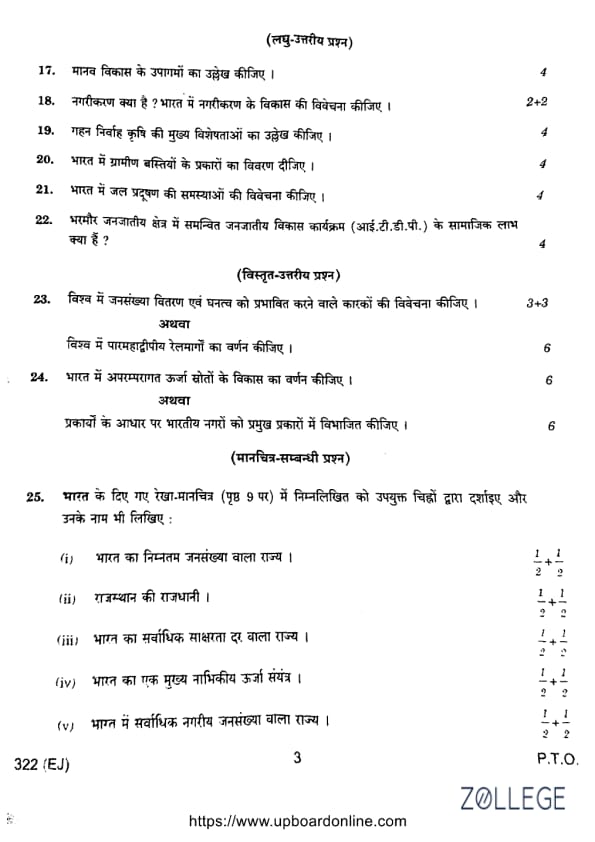
Question 17:
Mention the approaches of human development.
View Solution
Solution: The main approaches to human development include:
- Income approach: Focuses on per capita income and economic growth.
- Welfare approach: Emphasizes healthcare, education, and quality of life.
- Capability approach: Developed by Amartya Sen, focuses on providing opportunities and social justice.
- Basic needs approach: Ensures essential requirements like food, shelter, and education.
Question 18:
What is urbanization? Discuss the development of urbanization in India.
View Solution
Solution: Urbanization is the transformation of rural areas into urban centers due to industrialization, economic growth, and improved living conditions.
Development in India:
- Rapid urbanization due to industrialization and job opportunities in cities like Mumbai, Delhi, and Bengaluru.
- Challenges include congestion, pollution, inadequate infrastructure, and slum proliferation.
- Government initiatives like Smart Cities Mission aim for sustainable urban growth.
Question 19:
Mention the main features of intensive subsistence agriculture.
View Solution
Solution: Key features include:
- High labor input per unit of land due to manual farming methods.
- Small landholdings, often fragmented due to inheritance laws.
- Traditional methods with minimal mechanization, leading to lower productivity.
- Cultivation of staple crops like rice and wheat for subsistence.
- Dependency on monsoon rains for irrigation.
- Practiced in densely populated regions like India and China.
Question 20:
Give an account of the rural settlement types in India.
View Solution
Solution: Rural settlements in India are classified as:
- Clustered settlements: Densely packed houses, commonly found in fertile plains.
- Semi-clustered settlements: Partially dispersed due to uneven terrain.
- Dispersed settlements: Scattered houses, typically in hilly or arid regions.
- Linear settlements: Developed along roads, rivers, or transport routes.
Question 21:
Discuss the problems of water pollution in India.
View Solution
Solution: Problems of water pollution in India include:
- Industrial waste: Toxic chemicals and heavy metals released into water bodies harm aquatic life and human health.
- Agricultural runoff: Pesticides and fertilizers lead to eutrophication and biodiversity loss.
- Untreated sewage: Urban areas discharge sewage, contributing to waterborne diseases.
- Groundwater contamination: Over-extraction leads to arsenic and fluoride contamination.
- Religious practices: Idol immersion and ritual bathing add pollutants to rivers like the Ganges.
- Poor waste management: Lack of proper disposal systems exacerbates pollution.
Question 22:
What are the social benefits of Integrated Tribal Development Programme (ITDP) in the Bharmaur tribal region?
View Solution
Solution: The social benefits include:
- Improved access to education and healthcare through mobile health units and scholarship programs.
- Better infrastructure, including roads and communication networks connecting remote areas.
- Skill development through vocational training and promotion of traditional crafts.
- Empowerment of tribal communities via self-governance and local decision-making.
- Preservation of cultural heritage while ensuring sustainable development.
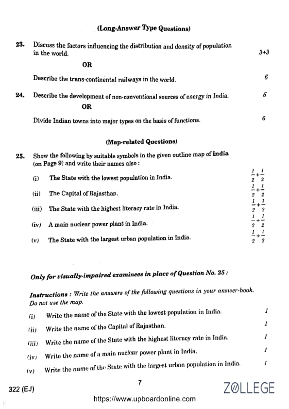
Question 23:
Discuss the factors influencing the distribution and density of population in the world.
View Solution
Solution: Factors influencing population distribution include:
- Physical factors: Climate, landforms, and fertile soil attract higher population densities (e.g., Nile and Ganges valleys).
- Economic factors: Urbanization, industrialization, and job opportunities lead to population concentration in cities.
- Social and cultural factors: Better healthcare, education, and cultural significance attract settlements.
- Political factors: Government policies, stability, and migration influence settlement patterns.
OR
Describe the trans-continental railways in the world.
View Solution
Solution: Trans-continental railways facilitate trade, travel, and connectivity across vast distances. Examples include:
- Trans-Siberian Railway: Moscow to Vladivostok, connecting Russia’s European and Far Eastern regions.
- Canadian Pacific Railway: Links Canada’s east and west coasts, supporting agriculture and trade.
- Union Pacific Railway: Connects the U.S. Atlantic and Pacific coasts, aiding economic integration.
- Australian Transcontinental Railway: Connects Perth and Sydney, facilitating transport across the Outback.
- Trans-Andean Railway: Links Chile and Argentina, overcoming mountainous terrain for trade.
Question 24:
Describe the development of non-conventional sources of energy in India.
View Solution
Solution: India is focusing on renewable energy sources:
- Solar energy: Large solar parks like Bhadla Solar Park and rooftop solar systems for urban and rural electrification.
- Wind energy: Leading wind energy producers, especially in Tamil Nadu and Gujarat.
- Biomass energy: Biogas plants and biomass gasifiers utilize agricultural waste for clean energy.
- Hydropower: Small and micro-hydropower projects in hilly regions ensure sustainable energy.
- Geothermal energy: Potential sites in Ladakh and the Himalayas are under exploration.
- Government policies: Incentives such as subsidies and tax benefits promote renewable energy adoption.
OR
Divide Indian towns into major types based on functions.
View Solution
Solution: Indian towns can be categorized as follows:
- Administrative towns: Centers of governance (e.g., Delhi, Bhopal).
- Industrial towns: Manufacturing and heavy industries (e.g., Jamshedpur, Bhilai).
- Commercial towns: Trade and financial hubs (e.g., Mumbai, Kolkata).
- Religious towns: Pilgrimage sites (e.g., Varanasi, Haridwar).
- Educational towns: Academic centers (e.g., Pune, Prayagraj).
- Port towns: Maritime trade centers (e.g., Chennai, Kochi).
- Tourist towns: Heritage and scenic destinations (e.g., Jaipur, Shimla).
- Military towns: Defense and cantonment zones (e.g., Ambala, Secunderabad).
Question 25:
Show the following by suitable symbols in the given outline map of India and write their names also:
(1) The State with the lowest population in India.
View Solution
Solution: Sikkim has the lowest population in India. Due to its small size and Himalayan terrain, it has a population of fewer than 700,000 people as per the latest census. Despite this, Sikkim is known for its rich biodiversity and cultural heritage.
(2) The Capital of Rajasthan.
View Solution
Solution: Jaipur, known as the "Pink City," is the capital of Rajasthan. It is famous for landmarks such as Hawa Mahal, Amber Fort, and Jantar Mantar, a UNESCO World Heritage Site.
(3) The State with the highest literacy rate in India.
View Solution
Solution: Kerala has the highest literacy rate in India, exceeding 90%. Its literacy success is attributed to strong education policies and social welfare initiatives.
(4) A main nuclear power plant in India.
View Solution
Solution: The Kudankulam Nuclear Power Plant in Tamil Nadu is one of India’s largest nuclear power plants, providing significant electricity to the southern region.
(5) The State with the largest urban population in India.
View Solution
Solution: Maharashtra has the largest urban population in India, with cities like Mumbai, Pune, and Nagpur contributing to its urban growth. Mumbai, India’s financial capital, is a major industrial and commercial hub.
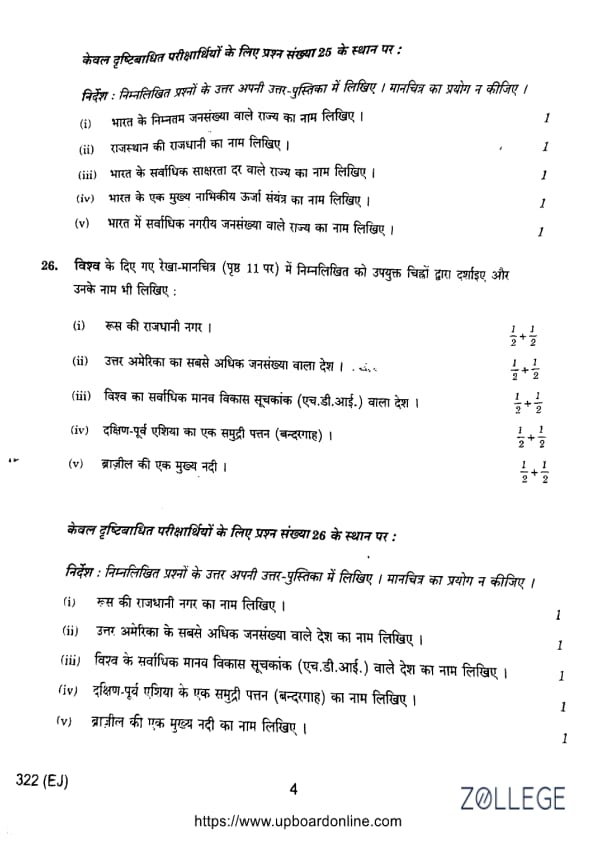
Only for Visually-Impaired Examinees (In Place of Question No. 25)
(1) Write the name of the State with the lowest population in India.
View Solution
Solution: Sikkim has the lowest population in India. It is a small Himalayan state known for its ecological diversity and sustainable development initiatives.
(2) Write the name of the Capital of Rajasthan.
View Solution
Solution: Jaipur is the capital of Rajasthan. It is famous for its historical significance and is a major cultural and tourist center.
(3) Write the name of the State with the highest literacy rate in India.
View Solution
Solution: Kerala has the highest literacy rate in India, reflecting its emphasis on education, gender equality, and public welfare.
(4) Write the name of a main nuclear power plant in India.
View Solution
Solution: Kudankulam Nuclear Power Plant in Tamil Nadu is one of India’s largest nuclear power plants and a major contributor to the country’s energy production.
(5) Write the name of the State with the largest urban population in India.
View Solution
Solution: Maharashtra has the largest urban population, with major metropolitan areas such as Mumbai, Pune, and Nagpur.
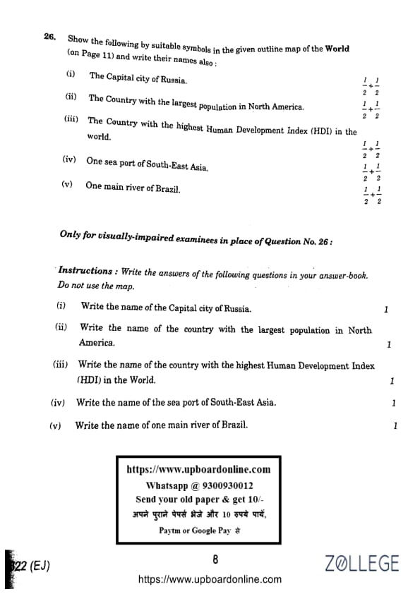
Question 26:
Show the following by suitable symbols in the given outline map of the World and write their names also:
(1) The Capital city of Russia.
View Solution
Solution: Moscow is the capital city of Russia. It serves as the country’s political and economic hub, home to landmarks such as the Kremlin and St. Basil’s Cathedral.
(2) The Country with the largest population in North America.
View Solution
Solution: The United States of America has the largest population in North America, exceeding 330 million. It is known for its cultural diversity, economic strength, and global influence.
(3) The Country with the highest Human Development Index (HDI) in the world.
View Solution
Solution: Norway consistently ranks highest in the Human Development Index due to its strong healthcare, education system, and income equality.
(4) One sea port of South-East Asia.
View Solution
Solution: Singapore is a major sea port in South-East Asia. It is one of the busiest ports in the world and a key player in global trade.
(5) One main river of Brazil.
View Solution
Solution: The Amazon River is the largest river in Brazil, supporting the Amazon Rainforest and serving as a major transportation and ecological resource.
Only for Visually-Impaired Examinees (In Place of Question No. 26)
(1) Write the name of the Capital city of Russia.
View Solution
Solution: Moscow is the capital city of Russia and an important global political and economic center.
(2) Write the name of the country with the largest population in North America.
View Solution
Solution: The United States of America has the largest population in North America, driven by economic opportunities and immigration.
(3) Write the name of the country with the highest Human Development Index (HDI) in the world.
View Solution
Solution: Norway has the highest HDI due to its well-developed social welfare, healthcare, and education systems.
(4) Write the name of the sea port of South-East Asia.
View Solution
Solution: Singapore is a major sea port and a leading center for international trade and commerce.
(5) Write the name of one main river of Brazil.
View Solution
Solution: The Amazon River is the main river of Brazil and a key source of biodiversity and ecological balance.