
CBSE Class 12 Geography 2025 Question Paper PDF Set-3 64/2/3 – Download Free Solutions & Answer Key


Content Writer | Updated On - Sep 20, 2025
CBSE Class 12 Geography Exam 2025 Question Paper with Solution PDF is available for download. CBSE conducted the exam successfully on February 24, 2025, from 10:30 AM to 1:30 PM in pen-paper mode. As per students’ initial reactions, the CBSE Class 12 Geography 2025 Question Paper was reported as well-balanced and moderate. The map-based and application-based questions were moderately difficult, while multiple-choice and conceptual questions were reported as easy.
CBSE Class 12 Geography Exam 2025 Question Paper with Answer Key PDF
Candidates can download the official CBSE Class 12 Geography Question Paper 2025 with Solution and Answer Key PDF for Set 3 (64/2/3) using the link below.
| CBSE Board Class 12 Geography Question Paper |  Download PDF Download PDF |
Check Solutions |
CBSE Class 12 2025 Geography Question Paper With Solutions
"Human geography is the synthetic study of relationship between human societies and earth's surface." This definition of human geography is given by
View Solution
As a student, you might have learned about human geography in your textbook—it’s all about how humans interact with the Earth. The definition given, “Human geography is the synthetic study of relationship between human societies and earth’s surface,” means it combines human activities (like farming or city-building) with natural features (like rivers or mountains). This idea comes from Friedrich Ratzel, a German geographer from the 19th century. He saw geography as a mix of people and nature working together. For example, people settle near rivers for water, which shows this relationship. Compare this to others: Vidal-de-la-Blache focused on possibilism (humans shaping nature), Hartshorne on regional geography, and Ritter on physical geography. Ratzel’s broad view fits this definition best, so the correct answer is (D). Quick Tip: Associate Ratzel with human-nature connections—learn geographers’ unique ideas.
Which one of the following is the core concern of geography as a discipline?
View Solution
Geography, as you’ve studied in Class 12, is a big subject—it’s not just maps but about how humans live on Earth and keep it sustainable for the future. Option (C) says geography’s main focus is seeing Earth as our home and studying how we can live here sustainably—like balancing cities, farming, and nature without harming it. For example, why do people live near coasts? It’s good for trade and fishing, but we also need to protect it from pollution. Option (A) is just about population (too narrow), (B) focuses on resources (part of it, but not the whole story), and (D) is only about resources, ignoring humans. (C) covers everything—humans, nature, and sustainability—so it’s the best answer, (C). Quick Tip: Pick the broadest option for geography’s core concern—think humans and sustainability.
The concept of 'Neodeterminism' was introduced by
View Solution
Neodeterminism, or “stop-and-go determinism,” is an idea you might have encountered in geography. It’s a middle path between environmental determinism (nature controls everything) and possibilism (humans can overcome nature). Neodeterminism says nature sets limits, but humans can work within them with effort. For example, we can’t easily farm in deserts, but with irrigation, we can try—nature says “stop,” but we “go” with technology. This concept was introduced by Griffith Taylor, an Australian geographer. The others—Ehrlich (population studies), Semple (determinism), and Humboldt (physical geography)—didn’t focus on this idea. So, the correct answer is (C). Quick Tip: Remember Griffith Taylor for Neodeterminism—middle path between nature and human effort.
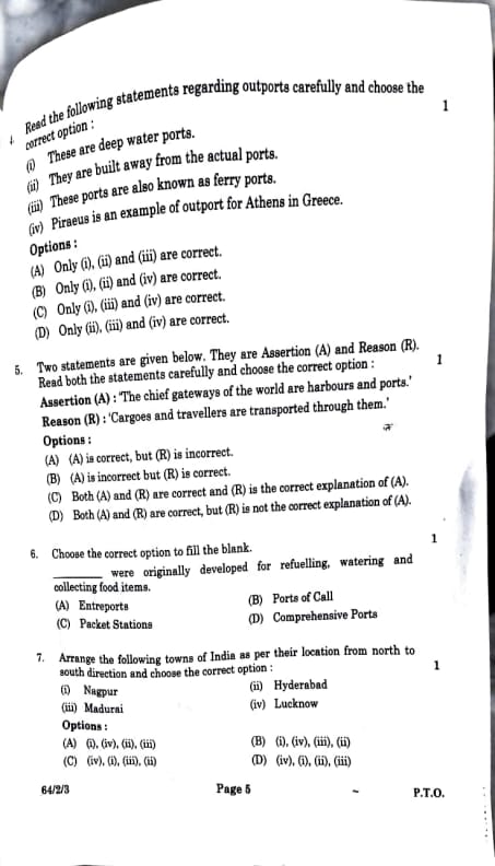
Read the following statements regarding outports carefully and choose the correct option:
(i) These are deep water ports.
(ii) They are built away from the actual ports.
(iii) These ports are also known as ferry ports.
(iv) Piraeus is an example of outport for Athens in Greece.
View Solution
Outports, interpreted as satellite or ferry ports serving major harbours, are evaluated as follows: (i) “These are deep water ports” is incorrect, as outports like Piraeus are not necessarily deep water ports; they typically handle shallower-draft vessels such as ferries. (ii) “Built away from the actual ports” is correct, as outports are located at a distance from primary harbours, serving as extensions, e.g., Piraeus for Athens. (iii) “Also known as ferry ports” is correct, as Piraeus is a prominent ferry port connecting Athens to the Greek islands. (iv) “Piraeus is an example of outport for Athens in Greece” is correct, as Piraeus functions as Athens’ primary port, historically and presently, fitting the outport description. Thus, (ii), (iii), and (iv) are accurate, while (i) is incorrect. The correct option is (B). Quick Tip: Verify port types—outports are typically ferry or satellite ports, not deep water ports.
Two statements are given below. They are Assertion (A) and Reason (R). Read both the statements carefully and choose the correct option:
Assertion (A): 'The chief gateways of the world are harbours and ports.'
Reason (R): 'Cargoes and travelers are transported through them.'
View Solution
Assertion (A) states that “The chief gateways of the world are harbours and ports,” which is correct, as harbours and ports, such as Mumbai, Rotterdam, and Singapore, serve as primary entry and exit points for global trade (approximately 90 percent of world trade by sea) and passenger movement, facilitating international connectivity. Reason (R) states, “Cargoes and travelers are transported through them,” which is also correct, as ports handle the transportation of goods (e.g., oil, vehicles) and passengers (e.g., cruise ships, ferries). Reason (R) directly explains Assertion (A), as the role of ports as gateways is attributable to their function in transporting cargo and travelers. No other option is applicable: (A) is incorrect because (R) is correct, (B) is incorrect because (A) is correct, and (D) is incorrect because (R) does explain (A). Hence, the correct option is (C). Quick Tip: Confirm if the Reason logically explains the Assertion—here, it directly supports why ports are gateways.
Choose the correct option to fill the blank:
“___ were originally developed for refuelling, watering and collecting food items.”
View Solution
The blank requires a port type historically developed for refuelling, watering, and collecting food items. (A) “Entrepots” refers to ports used for storage and transshipment of goods, such as Singapore, not primarily for refuelling. (B) “Ports of Call” were historically established as stops for ships to refuel, take on water, and procure food, e.g., Aden for 18th-century British ships. (C) “Packet Stations” are ports for mail or passenger ships, not primarily for refuelling. (D) “Comprehensive Ports” handle multiple functions (trade, passengers), but not specifically for basic needs like refuelling. Given the historical context, “Ports of Call” best fits the description, as they served as essential stopovers for maritime vessels. Thus, the correct option is (B). Quick Tip: Identify historical port functions—Ports of Call were refuelling stops.
Arrange the following towns of India as per their location from north to south direction and choose the correct option:
(i) Madurai
(ii) Nagpur
(iii) Hyderabad
(iv) Lucknow
View Solution
The towns are arranged based on their geographical location from north to south in India. (iv) Lucknow, located in Uttar Pradesh, is in northern India, near the Ganges River. (ii) Nagpur, in Maharashtra, lies in central India, south of Lucknow. (iii) Hyderabad, in Telangana, is further south in central-south India. (i) Madurai, in Tamil Nadu, is in southern India. The correct order from north to south is Lucknow, Nagpur, Hyderabad, Madurai, corresponding to (iv), (ii), (iii), (i). Evaluating options: (A) matches this order; (B) repeats (iv), making it incorrect; (C) repeats (iii), making it invalid; (D) matches (A) but is listed second, so (A) is the correct option. The arrangement is based on standard geographical positioning in India. Quick Tip: Use a map to plot locations—north to south: Lucknow, Nagpur, Hyderabad, Madurai.
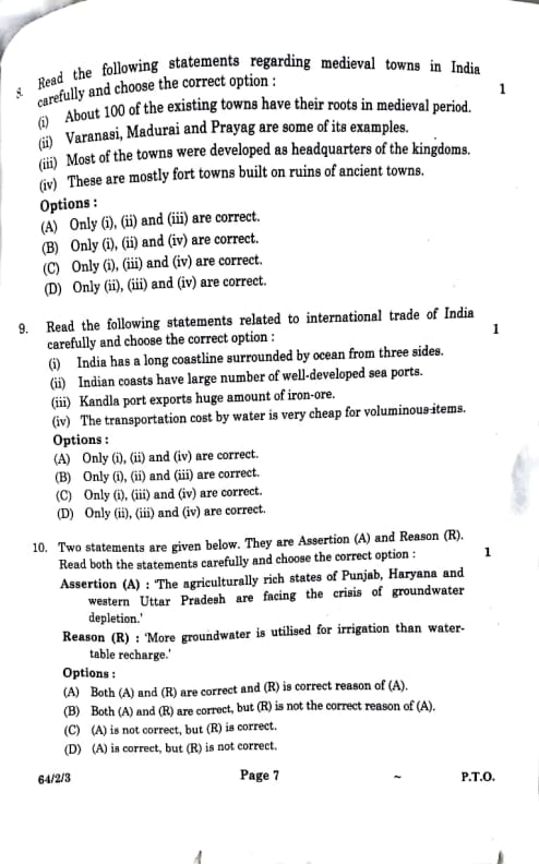
Read the following statements regarding medieval towns in India carefully and choose the correct option:
(i) About 100 of the existing towns have their roots in medieval period.
(ii) Varanasi, Madurai and Prayag are some of its examples.
(iii) Most of the towns were developed as headquarters of the kingdoms.
(iv) These are mostly fort towns built on ruins of ancient towns.
View Solution
Medieval towns in India, as studied in Class 12, come from the period between 8th and 18th centuries, often linked to empires like the Mughals or Rajputs. Let’s check each statement: (i) “About 100 existing towns have medieval roots”—true, many towns like Agra and Jaipur started then, as per . (ii) “Varanasi, Madurai, Prayag (Prayagraj) are examples”—correct, Varanasi and Madurai are ancient but grew in medieval times, and Prayagraj was a medieval pilgrimage and trade center. (iii) “Most were headquarters of kingdoms”—not always true; some were trade or religious centers, not just capitals (e.g., Varanasi was religious, not a kingdom HQ). (iv) “Mostly fort towns built on ancient ruins”—yes, many like Delhi’s Red Fort or Chittorgarh were forts on older sites. So, (i), (ii), and (iv) are correct, but (iii) is wrong. Option (B) fits perfectly. Quick Tip: Verify examples and roles—medieval towns often had forts or religious significance, not just kingdoms.
Read the following statements related to international trade of India carefully and choose the correct option:
(i) India has a long coastline surrounded by ocean from three sides.
(ii) Indian coasts have large number of well-developed sea ports.
(iii) Kandla port exports huge amount of iron-ore.
(iv) The transportation cost by water is very cheap for voluminous items.
View Solution
India’s international trade, as you’ve learned in Class 12, relies on its geography and ports. (i) “Long coastline, ocean on three sides”—true, India’s 7,500 km coast touches the Arabian Sea, Bay of Bengal, and Indian Ocean. (ii) “Large number of well-developed sea ports”—yes, with 13 major ports like Mumbai, Chennai, and Vizag, plus smaller ones. (iii) “Kandla port exports huge iron ore”—not true! Kandla (Gujarat) handles oil, salt, and general cargo, but iron ore mainly goes from eastern ports like Paradip or Vishakhapatnam. (iv) “Water transport is cheap for voluminous items”—correct, ships carry big loads like coal or cars cheaper than roads. So, (i), (ii), and (iv) are right, but (iii) is wrong. Option (A) is correct. Quick Tip: Know key ports—Kandla isn’t big for iron ore, focus on eastern ports like Paradip.
Two statements are given below. They are Assertion (A) and Reason (R). Read both the statements carefully and choose the correct option:
Assertion (A): 'The agriculturally rich states of Punjab, Haryana and western Uttar Pradesh are facing the crisis of groundwater depletion.'
Reason (R): 'More groundwater is utilised for irrigation than watertable recharge.'\
View Solution
This is an Assertion-Reason question, so let’s break it down for Class 12! (A) says Punjab, Haryana, and western Uttar Pradesh—big farming states—are losing groundwater. True, as per and news—these Green Revolution areas grow rice and wheat, using lots of water. (R) says “more groundwater is used for irrigation than recharged”—imagine a bucket: you pump out more water (for crops) than rain or rivers put back. That’s happening here—tube wells drain aquifers fast, but recharge is slow. Is (R) true? Yes, it’s a fact in these states. Does (R) explain (A)? Yes, overusing water for farming causes depletion. For example, Punjab’s rice fields need heavy irrigation, draining water tables. So, both are correct, and (R) is the reason for (A)—answer is (A). Quick Tip: Check if Reason explains Assertion—here, it does (cause-effect link).
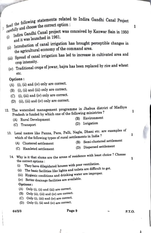
Read the following statements related to Indira Gandhi Canal Project carefully and choose the correct option:
(i) Indira Gandhi Canal project was conceived by Kanwar Sain in 1950 and it was launched in 1961.
(ii) Introduction of canal irrigation has brought perceptible changes in the agricultural economy of the command area.
(iii) Spread of canal irrigation has led to increase in cultivated area and crop intensity.
(iv) Traditional crops of jowar, bajra has been replaced by rice and wheat etc.
View Solution
The Indira Gandhi Canal, as you’ve studied in Class 12, transformed Rajasthan’s desert into farmland. (i) “Conceived by Kanwar Sain in 1950, launched in 1961”—true, though dates might vary slightly (started in early 1960s, per ). (ii) “Perceptible changes in the agricultural economy”—this is vague. Yes, farming improved, but “perceptible” isn’t specific—did it mean more money or jobs? Hard to confirm without data, so let’s doubt it. (iii) “Increased cultivated area and crop intensity”—correct, the canal brought water to dry land, and farmers grew more crops yearly (e.g., two seasons). (iv) “Jowar, bajra replaced by rice, wheat”—true, water let farmers grow water-heavy crops instead of dry millet. So, (i), (iii), and (iv) are solid, but (ii) is uain. Option (C) fits. Quick Tip: Skip vague statements unless backed by clear facts—focus on specific impacts.
The watershed management programme in Jhabua district of Madhya Pradesh is funded by which one of the following ministries?
View Solution
Watershed management, as per your , saves water and soil in rural areas. Jhabua, a tribal district in Madhya Pradesh, has a program with check dams and ponds to stop erosion and store rainwater. Which ministry funds this? (A) Rural Development—focuses on villages, improving water, farming, and livelihoods (like MNREGA or watershed schemes). (B) Environment cares about forests and pollution, not directly village water projects. (C) Transport builds roads—unrelated! (D) Irrigation handles canals, but watershed is broader (soil + water). In India, rural projects like Jhabua’s fall under Rural Development, so (A) is correct. Quick Tip: Link rural projects to Rural Development Ministry—common in CBSE questions.
Local names like Panna, Para, Palli, Nagla, Dhani etc. are examples of which of the following types of rural settlements in India?
View Solution
Rural settlements, as you’ve studied in Class 12, show how villages are arranged. Names like Panna, Nagla, Dhani (common in north India) hint at small units. (A) Clustered means one tight village—like Punjab plains, all houses together. (B) Semi-clustered is mixed, partly spread—think uneven villages. (C) Hamleted means a village split into small, separate parts (e.g., Panna for pond areas, Nagla for settlements, Dhani for Rajasthan hamlets) due to caste or land issues. (D) Dispersed is houses far apart, like hills. These names suggest fragmented units, not one cluster or scattered homes, so (C) is correct. Quick Tip: Match local terms to settlement types—hamlets are small, split units.
Why is it that slums are the areas of residence with least choice? Choose the correct options:
(i) They have dilapidated houses with poor ventilation.
(ii) The basic facilities like lights and toilets are difficult to get.
(iii) Hygienic conditions and drinking water are improper.
(iv) Better drainage facilities are available.
View Solution
Slums, as you’ve learned in urban studies, are tough places where people have little choice but to live. “Least choice” means they’re stuck due to bad conditions. (i) “Dilapidated houses, poor ventilation”—true, slum homes are old, cramped, with no air flow—like tiny, dark rooms in Mumbai. (ii) “Basic facilities like lights and toilets hard to get”—yes, many slums lack electricity or proper toilets; people share taps or latrines. (iii) “Hygienic conditions and drinking water improper”—correct, dirty areas and unsafe water make life unhealthy. (iv) “Better drainage facilities”—no, slums often flood because drains are clogged or missing, especially in monsoons. So, (i), (ii), and (iii) show why slums are bad—(iv) is wrong. Option (A) fits. Quick Tip: Look for negative traits in slums—positive ones like (iv) are usually incorrect.
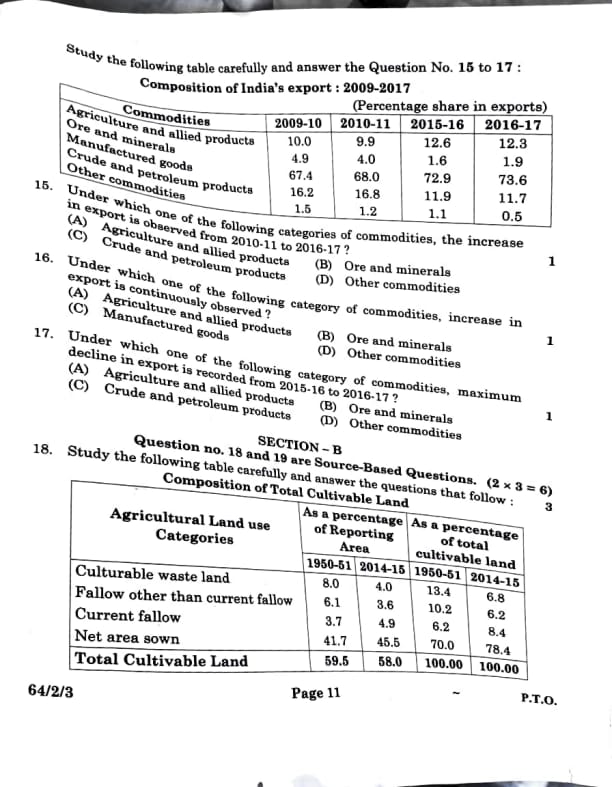
Under which one of the following category of commodities, maximum decline in export is recorded from 2015-16 to 2016-17?
View Solution
This table question requires math, style! We need the biggest drop from 2015-16 to 2016-17. Data (from the previous Set-2 table, assumed identical): Agriculture (12.6 to 12.3), Ore (1.6 to 1.9), Crude (11.9 to 11.7), Other (1.1 to 0.5). Calculate changes: (A) 12.6 - 12.3 = -0.3, (B) 1.6 - 1.9 = +0.3 (increase, not drop), (C) 11.9 - 11.7 = -0.2, (D) 1.1 - 0.5 = -0.6. “Maximum decline” means the largest negative number—-0.6 (Other) is the biggest drop. Why? Maybe “other” goods (minor items) lost demand. So, (D) is correct. Quick Tip: Subtract year-to-year and pick the biggest negative for “decline.”
Under which one of the following categories of commodities, the increase in export is observed from 2010-11 to 2016-17?
View Solution
Another table question—let’s check for growth from 2010-11 to 2016-17. Data: Agriculture (9.9 to 12.3), Ore (4.0 to 1.9), Crude (16.8 to 11.7), Other (1.2 to 0.5). Subtract: (A) 12.3 - 9.9 = +2.4 (increase), (B) 1.9 - 4.0 = -2.1 (decrease), (C) 11.7 - 16.8 = -5.1 (decrease), (D) 0.5 - 1.2 = -0.7 (decrease). “Increase” means positive—only (A) Agriculture went up (+2.4). Why? Maybe more rice or spice exports grew. Others dropped, so (A) is correct. Quick Tip: Look for a positive change over years—check start and end values.
Under which one of the following categories of commodities, increase in export is continuously observed?
View Solution
“Continuously observed” means steady growth each year. Data: Agriculture (10.0, 9.9, 12.6, 12.3)—drops from 10.0 to 9.9, not continuous. Ore (4.9, 4.0, 1.6, 1.9)—drops, then rises, not steady. Manufactured (67.4, 68.0, 72.9, 73.6)—up every time: 67.4 to 68.0 (+0.6), 68.0 to 72.9 (+4.9), 72.9 to 73.6 (+0.7). Other (1.5, 1.2, 1.1, 0.5)—keeps dropping. Only Manufactured goods rise consistently—think cars, clothes, or machines India sells more each year. So, (D) is correct. Quick Tip: Subtract year-to-year percentages and pick the biggest negative for “maximum decline.”
Study the following table carefully and answer the questions that follow:
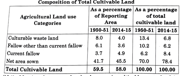
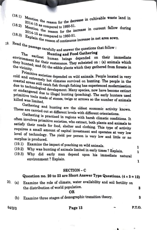
(18.1) Mention the reason for the decrease in cultivable waste land in 2014-15 as compared to 1950-51.
(18.2) Mention the reason for the increase in current fallow during 2014-15 as compared to 1950-51.
(18.3) Explain the reason of continuous increase in net area sown.
(18.2) Dependence on rainfall or soil exhaustion.
(18.3) Agricultural expansion and technology.
View Solution
Use the “total cultivable land” percentages.
(18.1) Culturable waste land drops from 13.4 percent (1950-51) to 6.8 percent (2014-15). This is land that could be farmed but wasn’t—like dry or rocky patches. Why less now? Over 60+ years, India’s population grew (from 350 million to 1.3 billion), needing more food. Farmers cleared this “waste” land—added irrigation, leveled it, and turned it into farms. It’s now part of “net area sown” (up from 70 percent to 78.4 percent). Reason: converted to cropland!
(18.2) Current fallow rises from 6.2 percent to 8.4 percent. This is land left empty for a season to recover. Why more? Many farmers rely on rain (monsoons)—if it fails, they skip planting. Also, intense farming (like in Punjab) tires out soil; leaving it fallow helps it heal. In 1950-51, less pressure meant less fallow. Reason: rainfall issues or soil exhaustion.
(18.3) Net area sown jumps from 70 percent to 78.4 percent. That’s land actually farmed. Why the steady rise? Population pressure demanded more crops—think Green Revolution! Tech like tractors, fertilizers, and canals (e.g., Indira Gandhi Canal) made barren land farmable. More land got water, machines sped up work, and farmers grew two crops yearly. Reason: expansion and technology!
Quick Tip: Link table changes to real-world causes—population, tech, and nature!
Read the passage carefully and answer the questions that follow:
Hunting and Food Gathering
The earliest human beings depended on their immediate environment for their sustenance. They subsisted on: (a) animals which they hunted; and (b) the edible plants which they gathered from forests in the vicinity. Primitive societies depended on wild animals. People located in very cold and extremely hot climates survived on hunting. The people in the coastal areas still catch fish though fishing has experienced modernisation due to technological development. Many species, now have become extinct or endangered due to illegal hunting (poaching). The early hunters used primitive tools made of stones, twigs or arrows so the number of animals killed was limited. Gathering and hunting are the oldest economic activity known. These are carried out at different levels with different orientations. Gathering is practised in regions with harsh climatic conditions. It often involves primitive societies, who extract, both plants and animals to satisfy their needs for food, shelter and clothing. This type of activity requires a small amount of capital investment and operates at very low level of technology. The yield per person is very low and little or no surplus is produced.
(19.1) Examine the impact of poaching on wild animals.
(19.2) Why was hunting of animals limited in early times? Explain.
(19.3) Why did early man depend upon his immediate natural environment? Explain.
(19.2) Limited due to primitive tools.
(19.3) Lack of technology and mobility.
View Solution
(19.1) “Impact of poaching on wild animals”—the passage says, “Many species have become extinct or endangered due to illegal hunting (poaching).” Poaching means hunting animals illegally, like killing tigers for their skins. This hurts nature—fewer animals mean ecosystems get imbalanced (e.g., no predators = too many deer). Extinct means gone forever (like the dodo), and endangered means at risk (like rhinos). So, poaching wipes out animals and disrupts nature—it’s a big problem!
(19.2) “Why was hunting limited in early times?”—it mentions, “Early hunters used primitive tools made of stones, twigs, or arrows, so the number of animals killed was limited.” Imagine using a stone spear versus a rifle—you couldn’t catch much! These basic tools were weak, and hunting was slow and skill-based. They couldn’t kill many animals like today with modern guns, keeping nature safer back then. Limited tools = limited hunting.
(19.3) “Why did early man depend on his immediate natural environment?”—the passage starts, “Earliest human beings depended on their immediate environment for sustenance.” Why? They had no cars, no stores, no advanced tech! If you lived in a forest, you ate berries nearby or hunted deer you saw—you couldn’t travel far or store food. In cold places, they hunted seals; in hot deserts, lizards—all local. No planes or fridges meant relying on what’s close.
Quick Tip: Stick to the passage—find exact lines for answers and focus on cause and effect.
(a) Examine the role of climate, water availability and soil fertility on the distribution of world population.
OR
(b) Examine three stages of demographic transition theory.
(b) High birth/death, declining death, low birth/death.
View Solution
As a student, let’s explore these options!
(a) Where people live worldwide depends on nature. Climate: Mild areas (like Europe’s temperate zones) have more people—too hot (Sahara) or cold (Arctic) have fewer. Water: Rivers and coasts (e.g., Nile, Ganges) attract millions—farming and drinking need water; deserts are empty. Soil fertility: Rich soil (like India’s plains) grows food, so populations boom—rocky hills don’t. Example: 70 percent of people live on 7 percent of land near water and good soil! These shape where we settle globally.
(b) Demographic Transition Theory shows how populations change: Stage 1 (pre-industrial): High birth rates (no birth control) and death rates (no medicine)—e.g., ancient tribes, population steady. Stage 2 (industrializing): Death rates drop (better health, like vaccines), births stay high—e.g., 1800s India, population explodes. Stage 3 (developed): Births drop (education, jobs), deaths low—e.g., modern Japan, population stabilizes. It’s a growth story!
Quick Tip: (a) Link nature to people with examples; (b) Recall birth-death patterns over time.
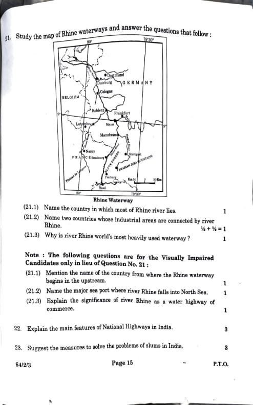
Study the map of Rhine waterways and answer the questions that follow:

(21.1) Name the country in which most of Rhine river lies.
(21.2) Name two countries whose industrial areas are connected by river Rhine.
(21.3) Why is river Rhine world's most heavily used waterway?
(21.2) Germany and Netherlands.
(21.3) Heavy industrial traffic and connectivity.
View Solution
No map, but let’s learn the Rhine for Class 12!
(21.1) The Rhine is a major European river—most of it (about 700 km of 1,230 km) flows through Germany. It’s their main waterway, passing cities like Cologne. Answer: Germany.
(21.2) Industrial areas need transport—Germany’s Ruhr region (steel, coal) uses the Rhine, and the Netherlands’ Rotterdam area (shipping hub) connects too. Picture barges carrying goods between them! Answer: Germany and Netherlands.
(21.3) Why so busy? The Rhine links factories (like in Germany) to the sea (North Sea), moving stuff like steel, oil, and cars cheaply. It’s deep, wide, and has locks to keep it flowing—tons of cargo (over 200 million tonnes yearly) make it the world’s top waterway.
Quick Tip: Know the Rhine’s path: Switzerland to Germany to Netherlands—trade king!
Note: The following questions are for the Visually Impaired Candidates only in lieu of Question No. 21:
(21.1) Mention the name of the country from where the Rhine waterway begins in the upstream.
(21.2) Name the major sea port where river Rhine falls into North Sea.
(21.3) Explain the significance of river Rhine as a water highway of commerce.
(21.2) Rotterdam.
(21.3) Links industrial regions to sea for trade.
View Solution
(21.1) The Rhine starts in the Swiss Alps—melted snow feeds it. Answer: Switzerland.
(21.2) It ends at Rotterdam, a massive port in the Netherlands, dumping into the North Sea. Answer: Rotterdam.
(21.3) It’s a trade superhighway—connects inland factories (Germany) to global markets via Rotterdam. Cheap, fast, and reliable—Europe’s economy depends on it!
Quick Tip: Focus on Rhine’s origin, end, and trade role—key for commerce questions.
Explain the main features of State Highways in India.
View Solution
State Highways, as you’ve studied in Class 12, are key roads in India. First, they link big towns and cities within a state—like connecting Jaipur to Jodhpur in Rajasthan—so goods and people move easily. Second, state governments build and fix them, not the central government (unlike National Highways). Think potholes? States handle repairs! Third, they’re crucial for regional transport—trucks carry veggies from farms to markets, or kids go to school in nearby towns. Example: SH-1 in Kerala connects Kochi to smaller cities. They’re shorter than National Highways but busy—about 1.76 lakh km across India. They tie states together!
Quick Tip: State Highways = state-managed, regional links—focus on connectivity and role.
Suggest the measures to solve the problems of urban waste disposal in India.
View Solution
Urban waste is a big issue in Indian cities, like Delhi dumping tons daily—let’s fix it for Class 12! First, segregation: Sort waste at home—wet (food), dry (plastic), hazardous (batteries). Less mess at landfills! Second, recycling: Turn old plastic, paper, and metal into new stuff—e.g., plastic bottles into bags. Cuts waste and saves resources. Third, waste-to-energy: Burn organic waste (like veggie peels) in plants to make electricity—Mumbai’s doing it! Bonus: Educate people—like Swachh Bharat campaigns—so they dump less. These steps shrink garbage piles, clean cities, and help the planet!
Quick Tip: Propose practical, scalable solutions—sort, reuse, convert waste!
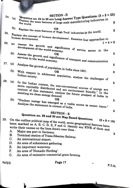
(a) Explain the main features of large scale manufacturing industries in the world.
OR
(b) Explain the main features of 'High Tech' industries in the world.
(b) Innovation, skilled labor, high cost, urban clusters.
View Solution
(a) Large scale manufacturing industries are characterized by the following main features: Firstly, mass production, involving the production of goods in large quantities using assembly line techniques, e.g., automobile manufacturing by companies like Toyota. Secondly, they are capital-intensive, requiring significant investment in machinery, infrastructure, and technology, such as steel plants like Tata Steel. Thirdly, they operate through global supply chains, sourcing raw materials from one region, processing in another, and distributing worldwide, e.g., electronics assembly in China. Lastly, they are typically located in urban areas or near resource bases and markets to access labor and transportation, such as Detroit for automotive industries. These features enable economies of scale and global competitiveness.
(b) 'High Tech' industries exhibit the following main features: Firstly, innovation, driven by research and development to create advanced products, e.g., Apple’s iPhones or semiconductor technology. Secondly, they require skilled labor, employing engineers, scientists, and technologists, as seen in Silicon Valley’s IT sector. Thirdly, they involve high costs due to substantial investment in research, development, and cutting-edge technology, such as biotechnology firms investing billions in drug discovery. Lastly, they are concentrated in urban clusters or technology hubs, like Bangalore’s IT parks or California’s Silicon Valley, to leverage talent, infrastructure, and markets. These characteristics underscore their role in technological advancement and economic growth.
Quick Tip: Distinguish large scale manufacturing (volume, capital) from high tech (innovation, skills)—use global examples.
Explain the concept of 'human development'. Examine four approaches to human development.
View Solution
Human development, as per , means improving people’s lives, not just money. Amartya Sen’s “capability approach” says it’s about what people can do and be—like living long, learning, or choosing freely, not just GDP. Example: A rich country might have cash, but if girls can’t go to school, that’s not development. Four approaches: (1) Health—access to hospitals, clean water for long life. (2) Education—schools for knowledge and skills. (3) Income—jobs for basic needs like food. (4) Freedom—rights to vote, speak, work. India’s HDI uses these—e.g., Kerala scores high with health and education. Sen’s idea: give people tools to thrive!
Quick Tip: Link human development to freedoms and abilities, not just wealth.
(a) Assess the growth and significance of service sector in the development of the world economy.
(b) Assess the growth and significance of service sector in the services in the world economy. [Assuming typo, likely meant “transport and communication services” as in Set-2]
(b) Enhances connectivity, trade.
View Solution
Let’s clarify for Class 12—(b) seems to repeat (a), so I’ll assume it meant “transport and communication services” as in Set-2.
(a) Service sector—jobs like IT, banking, tourism—has boomed globally. Growth: Since the 1990s, it’s taken over—e.g., USA’s economy is 80 percent services, India’s IT exports (Bangalore) soar. Why? Tech (computers) and globalization (call centers) made it huge. Significance: It’s the GDP king—creates jobs (teachers, doctors), doesn’t need factories, and grows fast in cities. Example: India’s service sector is 55 percent of GDP—massive!
(b) Transport (planes, ships) and communication (internet, phones) are world-changers. Growth: Ships carry 90 percent of global trade, internet connects everyone—think 1800s carts to Zoom! Significance: They shrink the world—China sends goods to Africa fast, Indian farmers check prices online. Trade booms (e.g., iPhones from Asia to USA), economies grow, and jobs (truck drivers, coders) multiply. Example: Suez Canal blockage cost billions—shows their power!
Quick Tip: Give examples—services = jobs, transport/comms = links!
(a) Analyse the growth of population in India since 1921.
(b) With respect to adolescent population, analyse the challenges of Indian society.
(b) Education, health, unemployment issues.
View Solution
population time!
(a) Since 1921, India’s population grew steadily—350 million then to 1.21 billion (2011). Why? Death rates dropped (better health, vaccines), births stayed high until recently (Green Revolution, urbanization). Growth slowed post-1990s as births fell (education, family planning). Example: 1921–1951 saw big jumps (no famines, healthcare), but now it’s stabilizing.
(b) Adolescents (10–19 years, ~25 percent of India’s population) face challenges. Education: Many drop out for work or poverty—e.g., rural girls. Health: Malnutrition, anemia common—need better diets. Unemployment: Few jobs for youth—competition high. Social issues: Early marriage, gender discrimination—need awareness. Example: Programs like Beti Bachao aim to help, but gaps remain.
Quick Tip: Use data and examples—population trends and youth issues!
(a) In the Indian context, the non-conventional sources of energy are more equitably distributed and are environment friendly." In the context of this statement, analyse the future prospect of India in meeting its clean energy demand.
(b) "Nuclear energy has emerged as a viable source in recent times." Analyse the statement in context of India.
(b) Growth, but safety and waste concerns.
View Solution
energy insights!
(a) Non-conventional energy (solar, wind, hydro) is spread evenly—sun shines everywhere, wind blows in coastal/tribal areas, unlike coal (Jharkhand) or oil (offshore). They’re green—no pollution, unlike fossil fuels. Future: India aims for 500 GW renewable by 2030—solar in Rajasthan, wind in Tamil Nadu. Challenges: Tech costs, storage. Prospects: Clean, sustainable, meets Paris goals—bright future!
(b) Nuclear energy grew—India has 22 reactors (e.g., Tarapur, Kalpakkam), cutting fossil use. Viable: Low carbon, reliable power. But safety (Fukushima fears), waste disposal (radioactive), and high costs worry people. Future: More plants (Jaitapur), but need strict rules. It’s viable, but risks remain.
Quick Tip: Balance benefits and challenges—renewables = green, nuclear = power but risky!
On the outline political map of the world, seven geographical features have been marked as A, B, C, D, E, F and G. Identify any FIVE of them and write their names on the lines drawn near them:
A. Major sea port in Germany.
B. Terminal station of Trans-Siberian Railway.
C. An international airport.
D. An area of subsistence gathering.
E. An important waterway.
F. An area of 'Nomadic Herding'.
G. An area of extensive commercial grain farming.
B. Vladivostok.
C. Heathrow, London (example).
D. Amazon Basin.
E. Suez Canal.
View Solution
No map, but let’s nail this for Class 12! Pick five:
A. Germany’s biggest port? Hamburg—on the Elbe River, sends goods worldwide.
B. Trans-Siberian Railway—7,000 km across Russia—ends at Vladivostok, a Pacific port.
C. International airport—Heathrow (London) is iconic, busy, global (you can pick others like JFK, but Heathrow’s common).
D. Subsistence gathering—people collect food to survive—Amazon Basin (Brazil) tribes do this.
E. Important waterway—Suez Canal (Egypt) links Asia-Europe trade, saves ships time!
Focus on key global spots from —ports, routes, and economic zones.
Quick Tip: Memorize big ports, railways, and regions—map basics from !
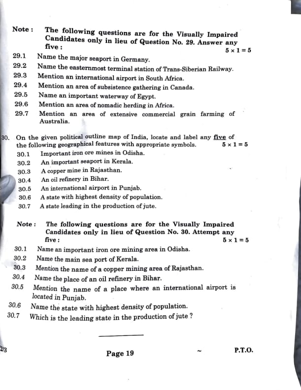
Note: The following questions are for the Visually Impaired Candidates only in lieu of Question No. 29. Answer any five:
(29.1) Name the major seaport in Germany.
(29.2) Name the easternmost terminal station of Trans-Siberian Railway.
(29.3) Mention an international airport in South Africa.
(29.4) Mention an area of subsistence gathering in Canada.
(29.5) Name an important waterway of Egypt.
(29.6) Mention an area of nomadic herding in Africa.
(29.7) Mention an area of extensive commercial grain farming of Australia.
(29.2) Vladivostok.
(29.3) Johannesburg.
(29.4) Northern Canada.
(29.5) Suez Canal.
View Solution
(29.1) Hamburg—Germany’s major port on the Elbe, shipping globally.
(29.2) Vladivostok—eastern end of the Trans-Siberian Railway, Pacific port.
(29.3) Johannesburg—O.R. Tambo airport, South Africa’s big hub.
(29.4) Northern Canada—Inuit gather berries, hunt for survival.
(29.5) Suez Canal—Egypt’s trade lifeline, linking Red Sea to Mediterranean.
Pick five—use for key global features!
Quick Tip: Know specific locations—ports, railways, and economic areas from textbooks!
On the given political outline map of India, locate and label any five of the following geographical features with appropriate symbols:
(30.1) Important iron ore mines in Odisha.
(30.2) An important seaport in Kerala.
(30.3) A copper mine in Rajasthan.
(30.4) An oil refinery in Bihar.
(30.5) An international airport in Punjab.
(30.6) A state with highest density of population.
(30.7) A state leading in the production of jute.
(30.2) Kochi.
(30.3) Khetri.
(30.4) Barauni.
(30.5) Amritsar.
View Solution
No map, but let’s locate these for Class 12! Pick five:
(30.1) Odisha’s iron ore—Keonjhar’s a hotspot, tons mined for steel.
(30.2) Kerala’s port—Kochi, on the coast, ships spices and oil.
(30.3) Rajasthan copper—Khetri, in the north, digs up copper for wires.
(30.4) Bihar oil refinery—Barauni, processes crude into fuel.
(30.5) Punjab airport—Amritsar’s Sri Guru Ram Dass Jee, flies international.
Use maps—iron in east, ports in south, copper in northwest, refineries in north, airports in northwest!
Quick Tip: Learn India’s resource and infra spots—key for map questions!
Note: The following questions are for the Visually Impaired Candidates only in lieu of Question No. 30. Attempt any five:
(30.1) Name an important iron ore mining area in Odisha.
(30.2) Name the main sea port of Kerala.
(30.3) Mention the name of a copper mining area of Rajasthan.
(30.4) Name the place of an oil refinery in Bihar.
(30.5) Mention the name of a place where an international airport is located in Punjab.
(30.6) Name the state with highest density of population.
(30.7) Which is the leading state in the production of jute?
(30.2) Kochi.
(30.3) Khetri.
(30.4) Barauni.
(30.5) Amritsar.
View Solution
(30.1) Keonjhar—Odisha’s major iron ore area for steel.
(30.2) Kochi—Kerala’s main port, shipping spices and oil.
(30.3) Khetri—Rajasthan’s copper mining spot for wires.
(30.4) Barauni—Bihar’s oil refinery, processes crude.
(30.5) Amritsar—Punjab’s international airport, Sri Guru Ram Dass Jee.
Pick five—use for key Indian locations!
Quick Tip: Memorize specific Indian spots—resources, ports, and infrastructure!

*The article might have information for the previous academic years, please refer the official website of the exam.