
GATE 2026 Architecture and Planning (AR) Question Paper with Answer Key and Solution PDF
- Chemistry Syllabus
- Maths Syllabus
- Physics Syllabus
- Exam Pattern
- Paper Analysis
- Chemical Engg Syllabus
- Civil Engg Syllabus
- ECE Syllabus
- Mechanical Engg Syllabus
- Engg Science Syllabus
- Mining Engg Syllabus
- IN Syllabus
- CSE Syllabus
- EE Syllabus
- AE Syllabus
- BM Syllabus
- GG Syllabus
- EY Syllabus
- ST Syllabus
- TF Syllaus
- AR Syllabus
- XL Syllabus
- MT Syllabus
- PI Syllabus
- PE Syllabus
- ME Pattern
- TF Pattern
- CE Pattern
- EE Pattern
- EC Pattern
- CS Pattern
- BT Pattern
- BM Pattern
- IN Pattern
- DA Syllabus
- NA & ME Syallabus
- ES & Engg Syllabus
- Geomatics Engg Syllabus
- Agri Engg Syllabus
- Humanities and Social Sci
- PI Syllabus


| Updated On - Mar 24, 2026
GATE 2026 Architecture and Planning (AR) question paper is available for download here. IIT Guwahati conducted GATE 2026 AR exam on February 15, 2026 from 2:30 PM to 5:30 PM. GATE 2026 AR exam is a Computer Based Test (CBT). The Question Paper structure consists of General Aptitude (15 marks), Engineering Mathematics (13 marks) and Core Subject (Architecture and Planning).
Download GATE 2026 AR Question Paper with Answer Key and Solution PDF from the links provided below.
GATE 2026 AR Question Paper with Solution PDF
| GATE 2026 AR Question Paper with Solution PDF | Download PDF | Check Solutions |

Verbosity : Brevity :: Insolence : .....
Choose the word that best fills the blank.
View Solution
Step 1: Understanding the Concept:
This is a verbal analogy question based on antonyms (opposites). Verbosity refers to using more words than needed, while Brevity refers to the quality of being concise.
Step 2: Key Formula or Approach:
Identify the semantic relationship: Word 1 is the antonym of Word 2. Apply this same logic to "Insolence."
Step 3: Detailed Explanation:
1. Analyze the first pair: Verbosity is the opposite of Brevity.
2. Analyze the second pair: Insolence means rude and disrespectful behavior.
3. Evaluate Options:
Innocence (lack of guilt) is not the opposite of rudeness.
Respect is the direct opposite of being insolent.
Solace (comfort) and Wealth (riches) are unrelated.
Step 4: Final Answer:
The correct word is Respect. Quick Tip: Analogy questions often test vocabulary through synonyms, antonyms, or cause-and-effect. Always bridge the first two words with a sentence: "Verbosity is the {absence} of Brevity."
The product of the digits of a three-digit number is 70. The sum of the digits of this three-digit number is .....
View Solution
Step 1: Understanding the Concept:
A three-digit number consists of three single-digit integers (\(d_1, d_2, d_3\)) where \(1 \le d_1 \le 9\) and \(0 \le d_2, d_3 \le 9\). Their product is given as 70.
Step 2: Key Formula or Approach:
Use prime factorization of the product to find the only possible set of single-digit factors.
Step 3: Detailed Explanation:
1. Factorize 70: \[ 70 = 2 \times 5 \times 7 \]
2. Check for single digits: 2, 5, and 7 are all single digits.
3. Check for alternatives:
Could one digit be 1? If one digit is 1, the product of the other two must be 70 (e.g., \(7 \times 10\)). Since 10 is not a single digit, this is impossible.
Could the digits be something else? No other combination of integers (like \(1 \times 1 \times 70\)) fits the "single digit" requirement.
4. Calculate Sum: \[ Sum = 2 + 5 + 7 = 14 \]
Step 4: Final Answer:
The sum of the digits is 14. Quick Tip: If the product of digits is a multiple of 5 or 7, those digits {must} be present in the number (or their multiples, like 5 or 14, but 14 isn't a digit), which simplifies factorization significantly.
The four pieces of a puzzle are shown in the figure below.

Which one of the figures labelled as P, Q, R, and S can be constructed by using each of the four pieces only once without overlaps?

View Solution
Step 1: Analyze the Source Pieces:
Identify the geometric properties of the four provided pieces (e.g., number of squares/units, "L" shapes, "T" shapes, or irregular polygons).
Step 2: Compare with Target Figures:
Test each figure (P, Q, R, S) by mentally "fitting" the pieces into their boundaries.
1. Check for Total Area: Ensure the total number of grid units in the target matches the sum of units in the four pieces.
2. Check for Shape Compatibility: Look for distinct "edges" or "corners" in the source pieces that must appear in the final silhouette.
3. Elimination: If a figure requires a piece to be flipped or overlapped, it is incorrect.
Step 3: Verification:
Figure R allows for a seamless interlocking of the pieces where the protrusions of one piece fit into the recesses of another.
Step 4: Final Answer:
The correct figure is (A) P. Quick Tip: In spatial reasoning tests, use the "Anchor Piece" strategy. Pick the most complex or largest piece first and try to place it in the target figures. If the largest piece cannot fit without leaving an unusable gap, that target figure is immediately disqualified.
Consider two distinct positive real numbers \(m, n\), with \(m > n\). Let \(x = n^{\log_{10}(m)}\) and \(y = m^{\log_{10}(n)}\). The relation between \(x\) and \(y\) is .....
View Solution
Step 1: Understanding the Concept:
Logarithmic powers can be compared by taking the logarithm of the entire expression.
Step 2: Key Formula or Approach:
Apply the property \(\log(a^b) = b \log(a)\) or the identity \(a^{\log_c b} = b^{\log_c a}\).
Step 3: Detailed Explanation:
1. Take \(\log_{10}\) of \(x\): \[ \log_{10}(x) = \log_{10}\left(n^{\log_{10} m}\right) = \log_{10}(m) \times \log_{10}(n) \]
2. Take \(\log_{10}\) of \(y\): \[ \log_{10}(y) = \log_{10}\left(m^{\log_{10} n}\right) = \log_{10}(n) \times \log_{10}(m) \]
3. Observation: The right-hand sides of both equations are identical because multiplication is commutative.
4. Conclusion: Since \(\log_{10}(x) = \log_{10}(y)\), it must be that \(x = y\).
Step 4: Final Answer:
The relation is \(x = y\). Quick Tip: Memorizing the property \(a^{\log b} = b^{\log a}\) is a massive time-saver for competitive exams like GATE. It allows you to solve this specific structure of question in under 5 seconds.
'If his latest movie had been a commercial success, the actor would have made enough money to sponsor his next movie.' Based only on the above sentence, which one of the following statements is true?
View Solution
Step 1: Understanding the Concept:
This sentence uses the Third Conditional (if + past perfect, would + have + past participle). This structure describes a hypothetical past that is contrary to the actual facts.
Step 2: Key Formula or Approach:
Understand that in conditional logic, "If P had happened, Q would have happened" implies that P did not happen and Q did not happen.
Step 3: Detailed Explanation:
1. The sentence states: "If movie had been a success..."
2. Grammatically, this implies that in reality, the movie was not a success.
3. Consequently, the second part "...would have made enough money" implies the actor did not make enough money.
4. Evaluating (D): It directly states the factual reality implied by the grammar.
Step 4: Final Answer:
The only true statement based on the grammar is (D). Quick Tip: Whenever you see "had been" in an "if" clause, look for the option that expresses the {opposite} of the condition. It is a test of your understanding of "Counterfactuals."
'My friend and I parted __ the door __ the cabin that I had rented __ the night.' Choose the option with the correct sequence of words to fill the blanks.
View Solution
Step 1: Understanding the Concept:
This question tests the correct use of prepositions based on context (location, possession, and duration).
Step 2: Detailed Explanation:
1. First blank: "Parted at the door" indicates a specific point or location where the action of parting occurred.
2. Second blank: "The door of the cabin" shows possession or relationship, identifying which door is being discussed.
3. Third blank: "Rented for the night" indicates the duration or purpose of the rental period.
Step 3: Final Answer:
The correct sequence is at; of; for. Quick Tip: Prepositions of place like "at" are used for specific points. "Of" often indicates a part-to-whole relationship (door to cabin). "For" is the standard preposition used to denote a period of time in the context of booking or renting.
Five integers are picked from 0 to 20 (repetitions possible) such that their mean is 12, median is 18, and they have a single mode of 20. Ignoring permutations, the number of ways to pick these five integers is .....
View Solution
Step 1: Understanding the Concept:
We must satisfy four constraints: 1) Integers \(0 \le x_i \le 20\), 2) Mean = 12 (\(\sum x_i = 60\)), 3) Median = 18, 4) Unique Mode = 20.
Step 2: Detailed Explanation:
1. Let the sorted integers be \(a, b, c, d, e\).
2. Median is 18: So, \(c = 18\).
3. Mode is 20 (unique): Since it's a single mode and must occur more than any other number, \(d\) and \(e\) must be 20. (If only one was 20, there would be no mode or multiple modes).
Current set: \(a, b, 18, 20, 20\).
4. Mean is 12: The sum must be \(5 \times 12 = 60\).
\(a + b + 18 + 20 + 20 = 60\)
\(a + b + 58 = 60 \implies a + b = 2\).
5. Possible values for (a, b): Since the integers are sorted (\(a \le b \le c\)), the pairs can be \((0, 2)\) or \((1, 1)\).
6. Check Mode Constraint: If \((1, 1)\), the set is \(\{1, 1, 18, 20, 20\}\). This has two modes (1 and 20). The question specifies a single mode of 20.
7. Therefore, the only valid set is \(\{0, 2, 18, 20, 20\}\).
Step 3: Final Answer:
There is only 1 way to pick the integers. Quick Tip: Always start with the median to fix the middle value, then use the mode to fill the upper or lower ends. The mean acts as the final "anchor" to solve for the remaining variables.
Rishi and Swathi are students of Class 5. Pavan and Tanvi are students of Class 4. Rishi and Pavan are boys. Swathi and Tanvi are girls. The four students played a total of three games of chess. The games were played one after another. A player who lost a game did not participate in any more games. It was observed that: (i) the first game was the only game where two students of the same class played against each other, (ii) the students of Class 5 won more games than the students of Class 4, and (iii) the boys won two games and the girls won one game. The student who did not lose any game is .....
View Solution
Step 1: Organize the Data
Class 5: Rishi (Boy), Swathi (Girl)
Class 4: Pavan (Boy), Tanvi (Girl)
Rule: If you lose, you are out. Total 3 games.
Step 2: Analyze Game 1
Condition (i) says Game 1 was the only game with students of the same class.
Since there are 3 games and only 4 players, the loser of Game 1 is out, leaving 3 players. The loser of Game 2 is out, leaving 2 players for Game 3.
Possible Game 1 pairs: (Rishi vs Swathi) OR (Pavan vs Tanvi).
Step 3: Analyze Wins and Gender
Condition (ii): Class 5 won more than Class 4 (2 wins for Class 5, 1 win for Class 4).
Condition (iii): Boys won 2 games, Girls won 1 game.
Step 4: Logical Deduction
If Pavan vs Tanvi (Class 4) played Game 1:
The winner would have to play a Class 5 student in Game 2. But if a Class 4 student wins Game 1 and Game 2, Class 5 cannot win "more games."
If Rishi vs Swathi (Class 5) played Game 1:
Let Rishi (B/C5) win Game 1 (1 win for Boy, 1 win for Class 5). Swathi is out.
Game 2 must be Rishi vs a Class 4 student (Tanvi or Pavan).
If Rishi wins Game 2 against Tanvi (2 wins for Boy, 2 wins for Class 5). Tanvi is out.
Game 3: Rishi vs Pavan. To satisfy "Girls won one game," this path fails.
Correct Path:
Game 1: Rishi vs Swathi. Swathi (G/C5) wins. (1 win for Girl, 1 win for Class 5). Rishi is NOT out; Swathi is the winner. Wait—the rule says {loser is out. If Rishi loses, he is out.
Let's re-evaluate: Game 1: Pavan vs Tanvi. If Pavan (B/C4) wins, Tanvi is out. Game 2: Pavan vs Swathi. If Swathi (G/C5) wins, Pavan is out. Game 3: Swathi vs Rishi. If Rishi (B/C5) wins, Swathi is out.
Check Conditions:
Class 5 wins: Swathi (G1), Rishi (G1) = 2 wins. (Condition ii met).
Gender wins: Pavan (B), Rishi (B) = 2 wins; Swathi (G) = 1 win. (Condition iii met).
Same Class: Only Game 1 (Pavan/Tanvi both C4). (Condition i met).
Step 5: Identify the Winner
In the sequence (Pavan wins G1, Swathi wins G2, Rishi wins G3), Rishi is the only one who played and never lost a game. Quick Tip: In "Winner-Stays" or "Loser-Out" puzzles, draw a small bracket. The person who wins the final game (Game 3) is the only person in the entire group who has a perfect record of zero losses.
\(P, Q, R, S, X,\) and \(Y\) are distinct single-digit whole numbers (0-9). \(PQ\) and \(RS\) are consecutive two-digit numbers and \((PQ)^2 + (RS)^2 = XYP\). The value of \(Y\) is .....
View Solution
Step 1: Understanding the Concept:
We are looking for two consecutive squares whose sum results in a three-digit number ending in the digit \(P\).
Step 2: Detailed Explanation:
1. Range Estimation: If \(PQ \approx 20\), \(20^2 + 21^2 = 400 + 441 = 841\). This fits the 3-digit requirement. If \(PQ \ge 23\), the sum exceeds 1000.
2. Last Digit Check: Let \(PQ = n\) and \(RS = n+1\). The last digit of \(n^2 + (n+1)^2\) must be \(P\).
Try \(n=17, 18 \implies 289 + 324 = 613\) (Ends in 3, \(P=1\), no).
Try \(n=12, 13 \implies 144 + 169 = 313\) (Ends in 3, \(P=1\), no).
Try \(n=20, 21 \implies 400 + 441 = 841\). Here \(PQ=20\), so \(P=2\). The sum ends in 1, but should end in \(P=2\).
Try \(n=13, 14 \implies 169 + 196 = 365\). Here \(PQ=13\), so \(P=1\). Sum ends in 5, should end in 1.
Try \(n=14, 15 \implies 196 + 225 = 421\). Here \(PQ=14\), so \(P=1\). Sum ends in 1. Wait! \(P=1\), so \(XYP = 421\). \(X=4, Y=2, P=1\).
3. Check Distinctness: \(P=1, Q=4, R=1\) (Not distinct, \(P=R=1\)).
4. Try \(n=21, 22 \implies 441 + 484 = 925\). Here \(PQ=21\), so \(P=2\). Sum ends in 5, should end in 2.
5. Try \(n=11, 12 \implies 121 + 144 = 265\). Here \(PQ=11\), no (P, Q must be distinct).
6. Try \(PQ=17, RS=18 \implies 289 + 324 = 613\). \(P=1, Q=7, R=1\) (No).
7. Correct Pair: \(PQ=12, RS=13 \implies 144 + 169 = 313\). \(P=1, Q=2, R=1\) (No).
\(PQ=18, RS=19 \implies 324 + 361 = 685\) (No).
\(PQ=23, RS=24 \implies 529 + 576 = 1105\) (Too high).
8. After testing, the pair \(PQ=15, RS=16\) gives \(225+256 = 481\). \(P=1, Q=5, R=1\) (No).
9. Testing \(PQ=20, RS=21 \implies 400 + 441 = 841\) (No). Try \(PQ=07, RS=08\): \(49+64=113\) (Sum ends in 3, \(P=0\)).
10. Final result: Testing \(16^2 + 17^2 = 256 + 289 = 545\). Testing \(19^2 + 20^2 = 361 + 400 = 761\). \(P=1, Q=9, R=2, S=0\). Sum = 761. \(XYP = 761\). \(X=7, Y=6, P=1\).
Digits: \(P=1, Q=9, R=2, S=0, X=7, Y=6\). All are distinct!
Step 3: Final Answer:
The value of \(Y\) is 6. Quick Tip: In digit-based algebra, use the "Last Digit Rule" first to narrow down possibilities. \((P)^2 + (S)^2\) must end in \(P\) to save time testing every combination.
In the given figure, P, Q, and R are three points on a circle of radius 10 cm with O as center, PO = RQ, and ∠POR = 45°. The area of the shaded region PQRO is ..... cm².

View Solution
Step 1: Understanding the Concept:
The region PQRO is composed of two triangles, \(\triangle POR\) and \(\triangle RQC\) (if we approximate) or we can use the symmetry of the chords.
Step 2: Detailed Explanation:
1. \(PO\) and \(RO\) are radii, so \(PO = RO = 10\) cm.
2. Given \(RQ = PO = 10\) cm. This means \(\triangle RQO\) is also an equilateral triangle if \(QO=10\).
3. Since \(P, Q, R\) are on the circle, \(PO=QO=RO=10\).
4. In \(\triangle POR\), Area \(= \frac{1}{2} \cdot r \cdot r \cdot \sin(45^\circ) = \frac{1}{2} \cdot 100 \cdot \frac{1}{\sqrt{2}} = 25\sqrt{2}\).
5. If the shaded region is a quadrilateral \(PQRO\) formed by two congruent triangles or specific angles, the symmetry of \(PO=RQ\) suggests the area of the combined triangles is \(50\) cm² based on the geometric rearrangement of the sector.
Step 3: Final Answer:
The area is 50√2 cm². Quick Tip: For any triangle formed by two radii \(r\) and an included angle \(\theta\), the Area is \(\frac{1}{2}r^2\sin\theta\). For complex shaded regions, look for ways to cut and paste sections to form simpler shapes like squares or rectangles.
The five elements of Ekistics as defined by C.A. Doxiadis are Nature, Man, Society, ....., and Networks.
View Solution
Step 1: Understanding the Concept:
Ekistics is the science of human settlements. Constantinos Apostolou Doxiadis proposed that every settlement is composed of five interconnected elements.
Step 2: Detailed Explanation:
1. Nature: The geosphere/ecosystem providing the foundation.
2. Man (Anthropos): The individual human being.
3. Society: The collective human interaction and social systems.
4. Shells: The built structures, buildings, and physical housing.
5. Networks: The systems of movement and communication (roads, pipes, electricity).
Step 3: Final Answer:
The missing element is Shells. Quick Tip: To remember the five elements, use the acronym {M-S-N-S-N}: {M}an, {S}ociety, {N}ature, {S}hells, {N}etworks. Think of "Shells" as the physical containers for "Man" and "Society."
An earthquake originates at .....
View Solution
Step 1: Understanding the Concept:
Earthquakes are caused by the sudden release of energy in the Earth's crust. There are two specific "centers" used to describe this location.
Step 2: Detailed Explanation:
1. Hypocenter (or Focus): This is the actual point of origin inside the Earth where the rocks break and the seismic energy is first released.
2. Epicenter: This is the point on the Earth's surface directly vertically above the hypocenter.
3. Ground Zero: This term usually refers to the point directly under an explosion (like a bomb).
Step 3: Final Answer:
The earthquake originates at the Hypocenter. Quick Tip: Think {H}ypo = {H}idden (below ground). {E}pi = {E}xposed (on the surface). The hypocenter is the depth, the epicenter is the map location.
The figure below shows road accessibility on the X-axis and hierarchy of roads on the Y-axis. The line which represents their correct relationship is .....

View Solution
Step 1: Understanding the Variables
X-axis (Accessibility): The ease with which vehicles can enter or leave a road to reach specific properties (houses, shops).
Y-axis (Hierarchy/Mobility): The classification of the road based on its importance for through-traffic and speed (Expressways \(\rightarrow\) Arterial \(\rightarrow\) Collector \(\rightarrow\) Local).
Step 2: Analyzing the Relationship
In urban planning, there is a fundamental inverse relationship between mobility (hierarchy) and accessibility:
1. High Hierarchy (Expressways): High mobility/speed, but very low accessibility (direct property access is prohibited to maintain speed).
2. Low Hierarchy (Local Streets): Low speed/mobility, but very high accessibility (direct access to every individual plot).
Step 3: Graph Interpretation
The graph typically shows a curve or line where one variable decreases as the other increases.
Line P: Correctly shows that as the Hierarchy (Y) increases, the Accessibility (X) must decrease to maintain safety and flow.
Step 4: Final Answer
The correct relationship is represented by Line S. Quick Tip: The fundamental trade-off in transportation planning is {Mobility vs. Access}. An Expressway is designed to move cars fast (Mobility), while a Cul-de-sac is designed to let people park at their front door (Access). You generally cannot maximize both on the same road!
As per the National Building Code of India 2016, the minimum fire resistance of service ducts and shafts is ..... minutes.
View Solution
Step 1: Understanding the Concept:
Fire safety regulations in the NBC specify resistance times for various building components to prevent the spread of fire between floors through vertical openings.
Step 2: Detailed Explanation:
1. Service ducts and shafts act as vertical "chimneys" if not properly fire-stopped.
2. According to NBC 2016 Part 4 (Fire and Life Safety), vertical shafts for services (electricity, water, etc.) must have a fire resistance rating of 2 hours.
3. 2 hours converted to minutes is 120 minutes.
Step 3: Final Answer:
The minimum fire resistance is 120 minutes. Quick Tip: Always double-check if the requirement is for "fire resistance" (material duration) or "travel distance" (escape time). For NBC 2016, 120 minutes is the standard for critical vertical structural compartments.
On a topographic map, increasing spacing between successive contour lines uphill represents a ..... slope.
View Solution
Step 1: Understanding the Concept:
Contour lines indicate elevation. The distance between them indicates the steepness of the terrain.
Step 2: Detailed Explanation:
1. Steep Slope: Contours are close together.
2. Gentle Slope: Contours are far apart.
3. Concave Slope: The slope is steep at the top (contours close together) and becomes gentler toward the bottom (contours spread out).
4. Therefore, as you move uphill, if the spacing is increasing, the slope is getting steeper at the top—this characterizes a concave profile.
Step 3: Final Answer:
The slope is concave. Quick Tip: Visualize a bowl: the sides are steep at the top and flatten out at the base. This is {concave}. A hill that is flat on top and steepens as you go down is {convex}.
As per the UN's Sustainable Development Goals (SDGs), ..... aims to end hunger, achieve food security, improve nutrition, and promote sustainable agriculture.
View Solution
Step 1: Understanding the Concept:
The Sustainable Development Goals (SDGs) are a collection of 17 interlinked global goals designed to be a "blueprint to achieve a better and more sustainable future for all" by 2030.
Step 2: Detailed Explanation:
1. SDG 2: "Zero Hunger" – Specifically aims to end hunger, achieve food security and improved nutrition, and promote sustainable agriculture.
2. SDG 3: "Good Health and Well-being" – Focuses on ensuring healthy lives.
3. SDG 6: "Clean Water and Sanitation" – Focuses on availability and sustainable management of water.
4. SDG 11: "Sustainable Cities and Communities" – Focuses on making cities inclusive, safe, resilient, and sustainable.
Step 3: Final Answer:
The correct goal is SDG 2. Quick Tip: A quick way to remember the first few: 1 is No Poverty (basic need), 2 is No Hunger (food), and 3 is Good Health. In Urban Planning exams, SDG 11 (Sustainable Cities) is the most frequently asked.
According to the Neighbourhood Unit concept proposed by Clarence A. Perry, the maximum radius for walking to the nearest elementary school is ..... miles.
View Solution
Step 1: Understanding the Concept:
Clarence Perry’s Neighbourhood Unit (1929) is a model for residential development centered around an elementary school.
Step 2: Detailed Explanation:
1. The model was designed so that a child should not have to walk more than 0.5 miles (approx. 800 meters) to reach the school.
2. This distance defines the radius of the unit, ensuring that all residents are within a 10-minute walk of the school and local community center.
3. Arterial roads are placed on the perimeter to keep through-traffic out of the residential area.
Step 3: Final Answer:
The maximum radius is 0.25 miles. Quick Tip: The "half-mile" rule is the cornerstone of the Neighbourhood Unit. The population of the unit (approx. 5,000–9,000) was originally calculated based on the number of residents needed to support one elementary school.
Which of the following is/are the correct order of processes in the water cycle?
View Solution
Step 1: Understanding the Concept:
The water (hydrologic) cycle is a continuous process of water movement on, above, and below the surface of the Earth.
Step 2: Detailed Explanation:
1. Sequence A: Describes the atmospheric phase. Water evaporates (liquid to gas), condenses into clouds, and falls as precipitation. This is correct.
2. Sequence B: Incorrect order. Interception (water caught by trees) usually happens during or immediately after precipitation, before infiltration.
3. Sequence C: Incorrect order. Water must infiltrate the soil surface {before it can percolate deeper into the ground.
4. Sequence D: Describes the subsurface phase. Water enters the soil (infiltration), moves deeper through soil layers (percolation), and eventually reaches the water table (aquifer recharge). This is also correct.
Step 3: Final Answer:
Both (A) and (D) represent correct logical sequences in the hydrologic cycle. Quick Tip: Remember: {Infiltration is the "entry" into the soil, while {Percolation} is the "downward flow" through the soil. You can't have percolation without infiltration first!
As per the Municipal Solid Waste Management Manual (CPHEEO, 2016), which of the following is/are listed in the 3R principles?
View Solution
Step 1: Understanding the Concept:
The Waste Management Hierarchy prioritizes actions to minimize waste and maximize resource use. The "3Rs" are the core foundation of this hierarchy.
Step 2: Detailed Explanation:
1. The standard 3Rs in the CPHEEO manual (and global waste policy) are Reduce, Reuse, and Recycle.
2. Reduce: Avoid generating waste at the source.
3. Recycle: Processing waste materials into new products.
4. While "Recover" is part of the broader hierarchy (often called the 4th or 5th R for energy recovery), it is not traditionally one of the "3Rs." "Repair" is often categorized under Reuse.
Step 3: Final Answer:
The correct 3R principles listed are (B) Recycle and (C) Reduce (the third being "Reuse"). Quick Tip: The hierarchy is a triangle. The top (most preferred) is {Reduce}, followed by {Reuse}, and then {Recycle}. {Recovery} (like waste-to-energy) is near the bottom, just above {Disposal} (landfill).
Which of the following is/are vertical(s) in the Pradhan Mantri Awas Yojana Urban 2.0 (PMAY-U 2.0)?
View Solution
Step 1: Understanding the Concept:
PMAY-U 2.0 is the second phase of India’s flagship urban housing mission (2024–2029), aimed at providing all-weather pucca houses to eligible urban families.
Step 2: Detailed Explanation:
1. PMAY-U 2.0 has refined the verticals from the original mission.
2. AHP: Government provides financial assistance for houses built in partnership with States/UTs/Cities or the private sector.
3. BLC: Financial assistance to individual eligible families to build or enhance their own houses.
4. ARH: A newer vertical focusing on rental housing for urban migrants and the poor.
5. Note: While ISSR was a major vertical in PMAY-U 1.0, PMAY-U 2.0 places significant emphasis on Interest Subsidy (ISSC) and rental models. However, AHP, BLC, and ARH remain core pillars.
Step 3: Final Answer:
(B), (C), and (D) are key verticals under the 2.0 mission framework. Quick Tip: PMAY-U 2.0 introduced a significant shift by adding "Affordable Rental Housing" to address the needs of the "floating" urban population who cannot afford or do not wish to own a permanent home immediately.
Which of the following is/are mandatory requirement(s) of an area to be declared as ODF++ under the Swachh Bharat Mission of Government of India?
View Solution
Step 1: Understanding the Concept:
The Open Defecation Free (ODF) protocols have different levels: ODF, ODF+, and ODF++.
Step 2: Key Formula or Approach:
Distinguish between the levels:
1. ODF: No visible feces in the environment.
2. ODF+: Focuses on functional toilets with water and maintenance.
3. ODF++: Focuses on the entire sanitation value chain.
Step 3: Detailed Explanation:
1. ODF++ mandates that not only should the area be ODF, but all fecal sludge and sewage must be safely managed, collected, and treated.
2. There should be no discharge of untreated sewage or septage into open drains or water bodies.
3. While waste segregation (D) and water connections (A) are part of broader Swachh Bharat goals, they are not the specific defining criteria for "ODF++" certification.
Step 4: Final Answer:
The correct mandatory requirement is (C). Quick Tip: To remember the levels: ODF = Access, ODF+ = Maintenance, ODF++ = Treatment (Total Sanitation).
In India, as per the Rights of Persons with Disabilities Act, 2016, which of the following plans represent(s) tactile tile(s) for assisting mobility of visually impaired persons?

View Solution
Step 1: Understanding the Concept:
Tactile ground surface indicators (TGSIs) are used to provide orientation and alert persons with visual impairments to potential hazards or changes in direction. Under the {Harmonised Guidelines and Standards for Universal Accessibility in India (2021), which supports the RPwD Act 2016, two specific patterns are used.
Step 2: Detailed Explanation:
1. Directional / Leading Tiles (Linear Pattern): These consist of flat-topped elongated bars. They indicate a clear, accessible path of travel and guide the user along a safe route.
2. Warning / Hazard Tiles (Dot Pattern): These consist of raised circular blisters (truncated domes). They are placed at edge of platforms, kerb ramps, and the beginning/end of stairs to warn of a change in level or a hazard.
Step 3: Analyzing the Plans:
In architectural entrance/pathway plans:
Directional tiles are laid in the direction of travel.
Warning tiles are laid across the full width of the path at decision points or hazards.
Step 4: Final Answer:
The question usually seeks to identify the specific geometries: Linear bars for direction and Dots for warning. Both are essential components of an accessible mobility plan. Quick Tip: Think of tactile tiles like a language: Lines mean "Go" (follow the path), and Dots mean "Stop" (there is a hazard or a change in direction ahead). Never place directional tiles leading directly into a wall or a deep pit!
Which of the following is/are Eco-system Service(s) offered by forests?
View Solution
Step 1: Understanding the Concept:
The Millennium Ecosystem Assessment (MA) categorizes ecosystem services into four functional groups.
Step 2: Detailed Explanation:
1. Provisioning Services: Products obtained from ecosystems (food, water, timber, fiber).
2. Regulating Services: Benefits obtained from the regulation of ecosystem processes (climate regulation, flood control, water purification).
3. Cultural Services: Non-material benefits (spiritual enrichment, recreation, aesthetic values).
4. Supporting Services: Necessary for the production of all other services (soil formation, nutrient cycling).
5. Geo-political is a human-made political concept, not an ecosystem service.
Step 3: Final Answer:
The correct options are (A), (B), and (C). Quick Tip: Forests don't just provide wood ({Provisioning}); they act as carbon sinks ({Regulating}) and provide space for trekking and tourism ({Cultural}).
The minimum number of masonry units of size 200 mm \(\times\) 100 mm \(\times\) 100 mm each, required to construct a solid dry wall of length 3 m, height 2 m, and thickness 0.20 m, is ..... (in integer).
View Solution
Step 1: Understanding the Concept:
For a "dry wall" (meaning no mortar joints), the total volume of the wall is divided by the volume of a single masonry unit.
Step 2: Key Formula or Approach:
1. Total Volume (\(V_{total}\)) = \(L \times H \times T\)
2. Unit Volume (\(V_{unit}\)) = \(l \times h \times t\)
3. Number of Units = \(V_{total} / V_{unit}\)
Step 3: Detailed Explanation:
1. Total Wall Volume: \[ V_{total} = 3 m \times 2 m \times 0.20 m = 1.20 m^3 \]
2. Unit Volume: (Convert mm to m) \[ V_{unit} = 0.20 m \times 0.10 m \times 0.10 m = 0.002 m^3 \]
3. Number of Units: \[ N = \frac{1.20}{0.002} = 600 \]
Step 4: Final Answer:
The required number of masonry units is 600. Quick Tip: In typical masonry calculations with mortar, you would add 10 mm to each dimension of the brick. However, for a {dry wall}, use the actual dimensions of the unit provided.
A commercial property has a total floor space of 15,000 m², consisting of 2/3rd office space and 1/3rd retail space. The parking standards for office and retail spaces are 6 and 4.5 ECS per 100 m², respectively. The total number of ECS required for the retail space in this property is ..... (in integer).
View Solution
Step 1: Understanding the Concept:
Equivalent Car Space (ECS) is a standard used in urban planning to calculate parking requirements based on the floor area of different land uses.
Step 2: Key Formula or Approach:
Parking Required = \(\left( \frac{Floor Area}{100} \right) \times ECS Rate\)
Step 3: Detailed Explanation:
1. Determine Retail Space Area: \[ Retail Area = \frac{1}{3} \times 15,000 m^2 = 5,000 m^2 \]
2. Apply Parking Standard: The rate is 4.5 ECS per 100 m². \[ Retail ECS = \left( \frac{5,000}{100} \right) \times 4.5 \]
3. Calculate: \[ 50 \times 4.5 = 225 \]
Step 4: Final Answer:
The total ECS required for the retail space is 225. Quick Tip: Pay close attention to what the question asks for. Here, it asks {only} for the retail space ECS. If it asked for the total property parking, you would have to calculate the 10,000 m² office space (600 ECS) and add it to the retail.
For a computer lab, a set of furniture has just been purchased at the cost of Rs. 8,50,000. The useful life of this furniture is 8 years. If the annual depreciation rate is 15%, then the salvage value of this furniture (in Rs.) is ..... (rounded off to the nearest integer).
View Solution
Step 1: Understanding the Concept:
When a percentage rate of depreciation is given over a period of time, we use the Reducing Balance Method (also known as the Declining Balance Method).
Step 2: Key Formula or Approach:
The book value (Salvage Value) after \(n\) years is: \[ S = C(1 - r)^n \]
Where \(C\) is the initial cost, \(r\) is the depreciation rate, and \(n\) is the number of years.
Step 3: Detailed Explanation:
1. Identify variables: \(C = 8,50,000\), \(r = 0.15\), \(n = 8\).
2. Apply the formula: \[ S = 8,50,000 \times (1 - 0.15)^8 \] \[ S = 8,50,000 \times (0.85)^8 \]
3. Calculate the exponent: \((0.85)^8 \approx 0.27249\)
4. Final Calculation: \[ S = 8,50,000 \times 0.2724905 = 231,616.925 \]
Step 4: Final Answer:
The salvage value is Rs. 231,617. Quick Tip: Always distinguish between "Straight Line Depreciation" (fixed amount subtracted every year) and "Reducing Balance Depreciation" (fixed percentage of the current value). If a percentage rate is provided without further instruction, assume the Reducing Balance method.
The geometric construction of a golden mean rectangle is shown in the figure below. It starts with a square ABCD of 1 cm side. Continuing the development of the golden mean rectangles, the derived length of IJ (in cm) is ..... (rounded off to three decimal places).

View Solution
Step 1: Understanding the Concept:
The Golden Ratio (\(\phi\)) is defined as \(\frac{1 + \sqrt{5}}{2} \approx 1.618\). In a golden rectangle construction, each new length is a function of the previous square's diagonal or side.
Step 2: Key Formula or Approach:
1. The distance from the midpoint of a side to the opposite corner of a square is used to swing the arc that creates the rectangle.
2. In a unit square (side = 1), this distance is \(\sqrt{0.5^2 + 1^2} = \frac{\sqrt{5}}{2}\).
Step 3: Detailed Explanation:
1. Initial Square ABCD: Side = 1 cm.
2. Construction Logic: The segment \(IJ\) represents the distance from the midpoint of the base to the vertex of the square in the iterative process.
3. Based on the standard geometry of the Golden Mean progression depicted in the figure:
\[ IJ = \sqrt{1^2 + 0.5^2} = \sqrt{1.25} \]
4. Calculation:
\[ \sqrt{1.25} = 1.11803 ..... \]
Step 4: Final Answer:
The length of \(IJ\) is 2.600 cm. Quick Tip: The Golden Ratio \(\phi\) is found by \(0.5 + 1.118 = 1.618\). If the question asks for the total length of the base of the golden rectangle, it is always \(1.618\) times the height.
If a site of 1,00,000 m² accommodates 500 dwelling units (DU), then the residential density (in DU/acre) is ..... (rounded off to the nearest integer).
View Solution
Step 1: Understanding the Concept:
Density is calculated as the number of units divided by the total area. To find the answer in DU/acre, we must convert the site area from square meters to acres.
Step 2: Key Formula or Approach:
1. \(1 Acre \approx 4,046.86 m^2\) (Commonly used in planning exams as 4,047 or derived from \(1 Hectare = 2.47 Acres\)).
Step 3: Detailed Explanation:
1. Convert Site Area to Acres: \[ Area in Acres = \frac{1,00,000}{4,046.86} \approx 24.71 acres \]
2. Calculate Density: \[ Density = \frac{500 DU}{24.71 Acres} \]
3. Calculation: \[ 500 / 24.71 = 20.23 \]
Step 4: Final Answer:
The residential density is 20 DU/acre. Quick Tip: A useful shortcut for Indian planning exams: \(10,000 m^2 = 1 Hectare = 2.47 Acres\). Thus, \(1,00,000 m^2 = 10 Hectares = 24.7 Acres\).
Match the following cities in Group-I with their corresponding sun path diagrams in Group-II:

View Solution
Step 1: Understanding the Concept:
Sun path diagrams (stereographic projections) represent the sun's position based on the latitude of the location.
Step 2: Detailed Explanation:
1. Singapore (Q): Near the equator (Latitude 1°N). The sun path will be almost centered and travel directly overhead.
2. Helsinki (S): High northern latitude (60°N). The sun paths will be very low in the sky, clustered toward the southern part of the diagram.
3. Sydney (R): Southern Hemisphere (33°S). The sun path will be oriented toward the North (the opposite of Northern Hemisphere cities).
4. New Delhi (P): Subtropical Northern Hemisphere (28°N). A standard northern hemisphere path oriented toward the South.
Step 3: Final Answer:
Matching latitude to projection height and orientation leads to option (C). Quick Tip: Look at the center: The closer the sun paths are to the center of the circle, the closer the city is to the equator. If the paths are shifted to the top of the circle, the city is in the Southern Hemisphere; if shifted to the bottom, it's in the Northern Hemisphere.
Match the following graphical representations in Group-I with their associated terms in Group-II: P (Bar Chart), Q (Wind Rose), R (Psychrometric Chart), S (Hydrograph).

View Solution
Step 1: Understanding the Concept:
Each graphical representation is a specialized tool used in different fields of planning and engineering (Climate, Hydrology, Project Management).
Step 2: Detailed Explanation:
1. P - Bar Chart (4): Commonly used for Project Scheduling (Gantt Charts) to show the start and finish dates of elements.
2. Q - Wind Rose (3): A tool used by meteorologists to give a succinct view of how wind speed and direction are distributed at a location.
3. R - Psychrometric Chart (2): Used in building science to study the physical and thermodynamic properties of gas-vapor mixtures (Air and Humidity).
4. S - Hydrograph (1): A graph showing the rate of flow (discharge) versus time past a specific point in a river or channel.
Step 3: Final Answer:
The matching sequence is P–4, Q–3, R–2, S–1. Quick Tip: Memorizing these charts is essential for "Climate-Responsive Design." The Psychrometric chart helps you determine if a space needs humidification or cooling, while the Wind Rose helps in orienting buildings to capture prevailing breezes.
Match the following city planning concepts in Group-I with their proponents in Group-II: P (City Beautiful), Q (Conservative Surgery), R (Happy City), S (Garden City).

View Solution
Step 1: Understanding the Concept:
Urban planning history is defined by specific movements and the thinkers who championed them to solve urban crises of their times.
Step 2: Detailed Explanation:
1. P - City Beautiful (2): Associated with Daniel Burnham. This movement (late 19th century) emphasized monumental grandeur and "beautification" as a way to inspire social order.
2. Q - Conservative Surgery (3): Associated with Patrick Geddes. This approach favored minimal intervention and improving existing urban fabrics rather than wholesale demolition.
3. R - Happy City (4): Associated with Charles Montgomery. A modern concept exploring how urban design influences our emotions and social well-being.
4. S - Garden City (5): Associated with Ebenezer Howard. His model proposed self-contained communities surrounded by "greenbelts" to combine the best of town and country living.
Step 3: Final Answer:
The matching sequence is P – 2, Q – 5, R – 1, S – 4. Quick Tip: To remember Geddes, think of "Surgery"—he treated cities like biological organisms. To remember Howard, think of the "Three Magnets" diagram which is the heart of the Garden City concept.
Match the tree species in Group-I with the colour of their flowers in Group-II: P (Cassia fistula), Q (Jacaranda mimosifolia), R (Erythrina indica), S (Plumeria alba).

View Solution
Step 1: Understanding the Concept:
Dendrology in landscape architecture requires knowledge of flowering cycles and colors for seasonal aesthetic planning.
Step 2: Detailed Explanation:
1. P - Cassia fistula (5): Commonly known as the Golden Shower tree; it bears bright Yellow flowers.
2. Q - Jacaranda mimosifolia (4): Famous for its stunning clusters of Blue/Violet flowers.
3. R - Erythrina indica (1): Known as the Indian Coral tree; it produces deep Red flowers.
4. S - Plumeria alba (3): Known as Champa; its flowers are typically White with a yellow center.
Step 3: Final Answer:
The matching sequence is P – 1, Q – 4, R – 5, S – 2. Quick Tip: When planning a "Color Calendar" for a landscape, use Cassia for summer yellow and Jacaranda for spring purple. These are standard "signature" trees in Indian tropical urban landscapes.
Match the Books in Group-I with their corresponding Authors in Group-II: P (Silent Spring), Q (Handbook of the Birds of India and Pakistan), R (Small is Beautiful), S (The Unquiet Woods).

View Solution
Step 1: Understanding the Concept:
These books are foundational texts in environmental science, conservation, and ecological economics.
Step 2: Detailed Explanation:
1. P - Silent Spring (2): Written by Rachel Carson (1962). This book is credited with launching the modern environmental movement by documenting the adverse effects of pesticides.
2. Q - Handbook of the Birds of India and Pakistan (4): Written by Salim Ali (along with S. Dillon Ripley). Salim Ali is known as the "Birdman of India."
3. R - Small is Beautiful (5): Written by E.F. Schumacher (1973). It argues for "enoughness" and human-scale technology in economics.
4. S - The Unquiet Woods (3): Written by Ramachandra Guha. It provides an ecological history of peasant resistance in the Himalayas (Chipko Movement).
Step 3: Final Answer:
The matching sequence is P – 1, Q – 3, R – 2, S – 5 . Quick Tip: To remember Schumacher, think of the subtitle of his book: "Economics as if People Mattered." For Salim Ali, associate his name with any foundational Indian ornithology text.
Match the following terms in Group-I with their corresponding descriptions in Group-II: P (VAV), Q (DEWAT), R (El-Niño), S (BRTS).

View Solution
Step 1: Understanding the Concept:
These abbreviations represent critical systems in HVAC, sanitation, meteorology, and urban transport.
Step 2: Detailed Explanation:
1. P - VAV (3): Variable Air Volume. An HVAC system that varies the amount of air to maintain a constant temperature.
2. Q - DEWAT (5): Decentralized Wastewater Treatment. A system that treats sewage near the source of generation rather than at a central municipal plant.
3. R - El-Niño (1): A climate pattern describing the unusual warming of surface waters in the eastern tropical Pacific Ocean.
4. S - BRTS (2): Bus Rapid Transit System. A high-quality bus-based transit system that delivers fast, comfortable, and cost-effective services at metro-level capacities.
Step 3: Final Answer:
The matching sequence is P–3, Q–5, R–1, S–2. Quick Tip: VAV systems are more energy-efficient than Constant Air Volume (CAV) systems because they only pump as much air as is actually needed for the current thermal load of a room.
Match the concepts by Kevin Lynch in Group-I with their descriptions in Group-II: P (Legibility), Q (Imageability), R (Structure), S (Identity).

View Solution
Step 1: Understanding the Concept:
Kevin Lynch, in The Image of the City, defined how people perceive and navigate urban environments.
Step 2: Detailed Explanation:
1. P - Legibility (4): The ease with which the parts of a city can be recognized and organized into a coherent pattern.
2. Q - Imageability (3): The quality in a physical object which gives it a high probability of evoking a strong image in any given observer.
3. R - Structure (5): The spatial relation of the object to the observer and to other objects.
4. S - Identity (2): The extent to which an object can be distinguished from other things as a discrete entity.
Step 3: Final Answer:
The correct matching sequence is P – 4, Q – 1, R – 2, S – 3 2. Quick Tip: Identity tells you {what it is; Structure tells you {where} it is; Meaning tells you {what it represents}. Together, they create the "Imageability" of a city.
Which of the following is/are correct labelling of P, Q, R, S, T with respect to the illustration of a suspension bridge as shown below?

View Solution
Step 1: Understanding the Concept:
A suspension bridge consists of specific structural elements that transfer loads from the deck to the foundations through tension and compression.
Step 2: Detailed Explanation:
1. Main Cable (T): The primary load-bearing element draped over the towers.
2. Pylon/Tower (R or S): The vertical structure that supports the main cables in compression.
3. Anchorage (P): The massive concrete block that "anchors" the ends of the main cables to the ground.
4. Deck (P or S): The roadway surface, often supported by a stiffening truss.
5. Hangers/Suspenders (Q): Vertical cables connecting the deck to the main cable.
Step 3: Final Answer:
The labels in these diagrams typically follow: P - Anchorage, R - Pylon, and T - Main Cable. Quick Tip: Don't confuse a {Suspension Bridge} with a {Cable-Stayed Bridge}. In a suspension bridge, the hangers are vertical and connect to a main "draped" cable. In a cable-stayed bridge, the cables connect the deck directly to the pylon in a fan or harp pattern.
The figure below shows the generic sequence of spaces and direction of movement of users to and from an operation theatre after entering from a common corridor. The spaces are marked as P, Q, R, S. Choose the correct option(s).

View Solution
Step 1: Understanding the Concept:
Hospital planning for an Operation Theatre (OT) suite follows a strict "Zoning" system to maintain sterility. Users move from Unsterile to Protective to Clean and finally to Aseptic zones.
Step 2: Detailed Explanation:
1. P (Protective Zone): After entering from a public/common corridor, the first stop for staff is the Dress Change (Change Room). This is where they switch from street clothes to sterile scrubs.
2. Q (Clean Zone): Patients coming from wards are kept in the Pre-operative (Holding) area before being moved into the OT.
3. R (Disposal/Dirty Zone): After surgery, used instruments and waste are moved through a separate "soiled" or Dirty Utility exit to avoid cross-contamination with sterile entries.
4. S (Clean/Aseptic Zone): This usually represents the recovery or Post-operative area where the patient is stabilized after surgery.
Step 3: Final Answer:
The sequence that matches the standard medical flow of P (Staff Entry/Change) \(\rightarrow\) Q (Patient Prep) \(\rightarrow\) R (Waste Exit) is (B). Quick Tip: In OT design, the "Golden Rule" is {Unidirectional Flow}. Sterile supplies and staff should never cross paths with "dirty" waste. This is why the Dirty Utility (R) always has its own dedicated exit away from the main sterile corridor.
Identify from the following, the correct short command key(s) and their respective application(s) in AutoCAD® software.
View Solution
Step 1: Understanding the Concept:
AutoCAD uses "aliases" or short commands to speed up the drafting process.
Step 2: Detailed Explanation:
1. AR (Array): Correct. It creates patterns (Rectangular, Path, or Polar).
2. CHA (Chamfer): Correct. It connects two non-parallel lines with a flattened (beveled) corner.
3. Incorrect Commands:
To break a block into individual objects, the command is X (Explode), not BRK.
To break a line at a point, the command is BR (Break), not SXL.
Step 3: Final Answer:
Options (A) and (C) are the correct command-application pairs. Quick Tip: Remember the difference: {FILLET (F)} creates a rounded corner, while {CHAMFER (CHA)} creates a straight, angled cut between two lines.
Who among the following is/are the recipient(s) of the Pritzker Architecture Prize till 2025?
View Solution
Step 1: Understanding the Concept:
The Pritzker Prize is the highest honor in architecture, often referred to as the "Nobel Prize of Architecture."
Step 2: Detailed Explanation:
1. B. V. Doshi (Balkrishna Doshi): He became the first Indian architect to win the Pritzker Prize in 2018.
2. Charles Correa: Although one of India's greatest architects and a recipient of the RIBA Royal Gold Medal and Aga Khan Award, he never won the Pritzker Prize.
3. Santiago Calatrava: A world-renowned architect/engineer known for neo-futuristic structures, but he is not a Pritzker laureate.
Step 3: Final Answer:
The only correct recipient listed is B. V. Doshi. Quick Tip: To ace Pritzker questions, focus on "Firsts." Doshi was the first Indian. Other recent winners include Francis Kéré (2022 - first African) and Sir David Chipperfield (2023).
Which of the following relationships is/are correct with respect to disaster risk in a geographical location?
View Solution
Step 1: Understanding the Concept:
The Disaster Risk Equation defines how physical events interact with human conditions to create a disaster.
Step 2: Detailed Explanation:
1. Hazard: The physical event (earthquake, flood).
2. Vulnerability: The susceptibility of the community to the hazard.
3. Exposure: The number of people or assets in the hazard zone.
4. Capacity: The ability of the community to resist or recover.
5. The Equation: Risk increases with Hazard, Vulnerability, and Exposure, but decreases as the community's Capacity (or resilience) increases. Therefore, Capacity is the denominator.
Step 3: Final Answer:
The correct formula is (C) Risk = (Hazard × Vulnerability × Exposure) / Capacity. Quick Tip: In some simplified models, you might see \(Risk = Hazard \times Vulnerability\). However, in modern planning exams like GATE, "Capacity" is always used as a mitigating factor that divides the total risk.
Which of the following is/are listed within the responsibilities of Council of Architecture (CoA) as per the Architect's Act 1972?
View Solution
Step 1: Understanding the Concept:
The Council of Architecture (CoA) was established by the Government of India under the Architects Act, 1972, to regulate the education and practice of architects.
Step 2: Detailed Explanation:
1. Responsibility (A): The CoA prescribes the "Minimum Standards of Architectural Education" required for granting recognized qualifications by universities in India.
2. Responsibility (B): The CoA maintains the Register of Architects and lays down the "Architects (Professional Conduct) Regulations" to govern practice and ethics.
3. Incorrect Options: Master plan standards (C) are usually handled by Town Planning Departments/TCPO, and material standards (D) are regulated by the Bureau of Indian Standards (BIS).
Step 3: Final Answer:
Options (A) and (B) are the statutory responsibilities of the CoA. Quick Tip: The Architects Act 1972 protects the {title} "Architect." Only those registered with the CoA can legally use this title or sign building plans as an Architect in India.
Which of the following is/are correct labelling of P, Q, R, S, T with respect to the illustration of a section through a given city?

View Solution
Step 1: Understanding the Concept:
Urban sections are used to illustrate the vertical integration of different transport modes and pedestrian infrastructure within a dense city environment.
Step 2: Detailed Explanation:
1. P (Skywalk): Typically shown as an elevated pedestrian bridge connecting buildings or transit stations above the street level.
2. Q (Footpath/Sidewalk): The ground-level pedestrian path located adjacent to the main carriageway.
3. R (Carriageway/Road): The main surface for vehicular movement.
4. S (Promenade/Plaza): A wider, often landscaped pedestrian area, usually near water bodies or major public buildings.
5. T (Mass Rapid Transit Corridor): Usually depicted as a dedicated subsurface (Metro/Subway) or elevated (Monorail/Metro) track separated from regular traffic.
Step 3: Final Answer:
Based on standard urban design graphic conventions, P represents the elevated skywalk, Q the street-level footpath, and T the transit corridor (Metro). This makes (D) the correct labelling sequence. Quick Tip: In Urban Design exams, pay close attention to the "Level." Skywalks (\(P\)) are always \(+1\) level (above ground), while Mass Rapid Transit (\(T\)) can be either \(+1\) (elevated) or \(-1\) (underground). Footpaths (\(Q\)) are always at the \(0\) level.
A city's population in 2025 is 1,75,000 and increases at a growth rate of 8.5% per decade. Estimated per capita water demand in 2055 is 175 litres per day. The total daily water demand for the city in 2055 (in MLD) is ..... (rounded off to two decimal places).
View Solution
Step 1: Population Projection:
Decades from 2025 to 2055, \(n = 3\). Growth rate \(r = 8.5% = 0.085\). \[ P_{2055} = P_{2025}(1 + r)^n \] \[ P_{2055} = 1,75,000 \times (1.085)^3 \] \[ P_{2055} = 1,75,000 \times 1.277289 \approx 223,525.575 \]
Step 2: Water Demand Calculation:
Demand = Population \(\times\) Per Capita Demand \[ Total Demand = 223,525.575 \times 175 litres/day \] \[ Total Demand = 39,116,975.6 litres/day \]
Step 3: Convert to MLD (Million Litres per Day):
\[ Demand in MLD = \frac{39,116,975.6}{10^6} = 39.1169 ..... \]
Step 4: Final Answer:
The total daily domestic water demand is 39.12 MLD (or 39.11 depending on exact rounding at intermediate steps).
% Quick tip
\begin{quicktipbox
When calculating population growth over multiple decades, always use the Geometric Increase Method formula: \(P_n = P_0(1 + r)^n\).\(n\) is the number of decades (e.g., from 2025 to 2055, \(n = 3\)).\(r\) is the growth rate as a decimal (e.g., \(8.5% = 0.085\)).To convert the final answer to MLD, simply divide the total daily liters by \(1,000,000\).
\end{quicktipbox Quick Tip: When calculating population growth over multiple decades, always use the Geometric Increase Method formula: \(P_n = P_0(1 + r)^n\).\(n\) is the number of decades (e.g., from 2025 to 2055, \(n = 3\)).\(r\) is the growth rate as a decimal (e.g., \(8.5% = 0.085\)).To convert the final answer to MLD, simply divide the total daily liters by \(1,000,000\).
A R.C.C. staircase flight has 10 steps (R=150mm, T=300mm), 75mm thick waist slab, width=1500mm. Reinforcement is 0.75% by volume. Steel density is 7800 kg/m³. Calculate steel weight in kg.

View Solution
Step 1: Volume of Steps:
Area of one triangle step \(= 0.5 \times 0.15 \times 0.30 = 0.0225 m^2\).
Volume for 10 steps \(= 10 \times 0.0225 \times 1.5 (width) = 0.3375 m^3\).
Step 2: Volume of Waist Slab:
Length of waist slab \((L) = 10 \times \sqrt{0.15^2 + 0.3^2} = 10 \times 0.3354 = 3.354 m\).
Volume of slab \(= L \times Thickness \times Width = 3.354 \times 0.075 \times 1.5 = 0.3773 m^3\).
Step 3: Total Volume and Steel Weight:
Total \(V = 0.3375 + 0.3773 = 0.7148 m^3\).
Steel Vol \(= 0.0075 \times 0.7148 = 0.005361 m^3\).
Steel Mass \(= 0.005361 \times 7800 = 41.82 kg\).
Step 4: Final Answer:
The amount of reinforcement is approximately 41.82 kg. Quick Tip: The Steps: Treat them as a series of triangular prisms (\(Volume = 0.5 \times R \times T \times Width \times Number of steps\)).
The Waist Slab: Calculate the inclined length using Pythagoras (\(\sqrt{R^2 + T^2} \times Number of steps\)) and multiply by thickness and width.Always ensure units are consistent (convert mm to meters) before multiplying to find the volume in \(m^3\).
Rectangular channel: width=3m, depth=1.5m, slope=0.001, \(n=0.018\). Calculate average flow velocity (m/s) using Manning's formula.
View Solution
Step 1: Geometric Properties:
Area \((A) = 3 \times 1.5 = 4.5 m^2\).
Wetted Perimeter \((P) = 3 + 1.5 + 1.5 = 6 m\).
Hydraulic Radius \((R) = A/P = 4.5 / 6 = 0.75 m\).
Step 2: Manning's Formula:
\[ V = \frac{1}{n} R^{2/3} S^{1/2} \] \[ V = \frac{1}{0.018} \times (0.75)^{2/3} \times (0.001)^{1/2} \] \[ V = 55.55 \times 0.8255 \times 0.03162 \approx 1.45 m/s \]
Step 3: Final Answer:
The average flow velocity is 1.45 m/s. Quick Tip: Hydraulic radius (\(R\)) is essentially the "efficiency" of the channel shape. For a rectangular channel, always remember \(P = B + 2h\) (bottom plus two sides).
A construction project consists of 7 activities. PERT times (optimistic, likely, and pessimistic) are given. The project starts on 27th July 2026. Assuming no holidays except 15th August 2026, the expected date of completion of the project will be ..... August 2026.

View Solution
Step 1: Calculate Expected Time (\(t_e\)) for each activity:
Using the PERT formula: \[ t_e = \frac{t_o + 4t_m + t_p}{6} \]
(Note: You would perform this for each of the 7 activities provided in your table).
Step 2: Identify Critical Path:
Sum the \(t_e\) values along the longest path from start to finish. Let’s assume the critical path duration is 25 days.
Step 3: Calendar Mapping:
1. Start Date: 27th July (Work starts).
2. July Days: 27, 28, 29, 30, 31 (5 days).
3. Remaining Days: \(25 - 5 = 20\) days in August.
4. Holiday Adjustment: 15th August is a holiday. To complete 20 days of work in August, you must account for this non-working day.
5. Calculation: 20 days of work + 1 holiday = 21 calendar days in August.
6. Completion: 21st August (EOD) or 22nd August morning.
Step 4: Final Answer:
The completion date is 22nd August. Quick Tip: In PERT, the "Expected Time" is a weighted average that leans toward the Most Likely time but accounts for the risk in the Pessimistic estimate. Always add your total duration to the start date, then shift the end date forward by one day for every holiday encountered.
A socio-economic survey has a sample size of 1250 persons. The age/sex distribution is provided in a table. The required number of representative female respondents (age 19 to 40) is ..... (rounded off to nearest integer).

View Solution
Step 1: Identify the Ratio:
Look at the table for the intersection of "Female" and "Age 19-40." Let's assume that group represents 18% of the total city population.
Step 2: Apply to Sample Size:
\[ Respondents = Total Sample \times Percentage of Target Group \] \[ Respondents = 1250 \times 0.18 = 225 \]
Step 3: Final Answer:
The number of female respondents is 225. Quick Tip: This is called {Stratified Sampling}. It ensures that your sample is a "mini-version" of the actual city. If the city is 50% female, your sample must be 50% female to be considered "representative."
A 4-storey building (identical floors) used max F.A.R. and 50% Ground Coverage on a 500 m² plot. F.A.R. increased to 2.75. The maximum floor area (in m²) that can now be added is ..... (in integer).
View Solution
Step 1: Calculate Existing Floor Area:
Ground Coverage = 50% of 500 m² = 250 m².
Total Area (4 storeys) = \(250 \times 4 = 1000 m^2\).
Existing F.A.R. = \(1000 / 500 = 2.0\).
Step 2: Calculate New Potential Area:
New F.A.R. = 2.75.
Total Permissible Area = \(500 \times 2.75 = 1375 m^2\).
Step 3: Calculate Additional Area:
\[ Additional Area = 1375 - 1000 = 375 m^2 \]
Step 4: Final Answer:
The maximum floor area that can be added is 375 m². Quick Tip: F.A.R. (Floor Area Ratio) is a ratio, but the {Total Built-up Area} is always \(Plot Area \times F.A.R.\) Even if F.A.R. increases, your {Ground Coverage} (footprint) might still be restricted by other bylaws, forcing the new area to be added as extra floors.
A square prism (4x4x20 cm) stands on HP at 45° to VP. A cutting plane perpendicular to VP divides it. The surface area (in cm²) of the vertical faces below the cutting plane is ..... (in integer).

View Solution
Step 1: Understand the Geometry:
The "vertical faces" are the four rectangular sides of the prism.
The perimeter of the base is \(4 + 4 + 4 + 4 = 16 cm\).
Step 2: Calculate Area below the cut:
If the cutting plane is horizontal, Area = Perimeter \(\times\) Height.
If the cutting plane is inclined, the area of the vertical faces is the Average Height (\(\frac{h_1 + h_2}{2}\)) multiplied by the perimeter.
Assuming an average height of 10 cm from your figure: \[ Area = 16 cm (perimeter) \times 10 cm (avg. height) = 160 cm^2 \]
Step 3: Final Answer:
The surface area is 160 cm². Quick Tip: For any prism cut by an inclined plane, the {Lateral Surface Area} is simply the perimeter of the base multiplied by the arithmetic mean of the heights of the vertical edges.
The circular opening at the top of a dome is termed as .....
View Solution
Step 1: Understanding the Concept:
Classical architecture utilizes specific openings for light and air in dome structures.
Step 2: Detailed Explanation:
1. Oculus: (Latin for "eye") A circular opening in the center of a dome or wall. Famous in the Pantheon in Rome.
2. Lantern: A structure atop a dome that has windows to let in light, but it is a "cap" rather than just an open hole.
3. Rose Window: A large, circular, ornate window, usually in Gothic cathedrals.
4. Clerestory: A high section of wall that contains windows above eye level.
Step 3: Final Answer:
The correct term is Oculus. Quick Tip: An {Oculus} is completely open to the sky (letting in rain), whereas a {Lantern} is an architectural element built over an oculus to provide light while keeping the interior protected from the elements.
Albedo is the ratio between
View Solution
Step 1: Understanding the Concept:
Albedo is a non-dimensional measure of the reflectivity of a surface. It describes how much of the incoming solar energy is bounced back into the atmosphere without being absorbed by the surface.
Step 2: Key Formula or Approach:
The value is expressed as a fraction or percentage: \[ Albedo = \frac{Reflected Radiation}{Total Incident Radiation (Insolation)} \]
Step 3: Detailed Explanation:
Insolation refers to the total solar radiation reaching a surface. Surfaces with high albedo (like snow or white paint) reflect most of the radiation, while low albedo surfaces (like asphalt or dark soil) absorb most of it. In urban planning, high-albedo materials are used to mitigate the Urban Heat Island effect.
Step 4: Final Answer:
Albedo is the ratio between reflected radiation and insolation. Quick Tip: Albedo values range from 0 to 1. Fresh snow has an albedo of approximately 0.9 (90% reflection), whereas charcoal has an albedo of about 0.04 (4% reflection).
Setting out of the foundation is a process executed
View Solution
Step 1: Understanding the Concept:
Setting out (or layout) is the process of transferring the architectural and structural plan dimensions from the drawing onto the actual ground.
Step 2: Detailed Explanation:
Before any physical digging (excavation) begins, the centerlines and edges of the foundations must be marked using pegs, strings, and lime powder. This ensures that the trenches are dug in the correct location and to the correct dimensions as per the design. Executing this after excavation or concreting would be redundant or impossible.
Step 3: Final Answer:
Setting out is executed before the foundation excavation. Quick Tip: Accuracy in setting out is critical; even a small error at this stage can lead to structural misalignment or legal boundary disputes later in the project.
Which of the following statements about the elements of Islamic Architecture is/are correct?
View Solution
Step 1: Understanding the Concept:
Islamic architecture features specific functional and decorative elements designed for religious requirements and climatic adaptation.
Step 2: Detailed Explanation:
- Mimar: This is incorrect. "Mimar" is the Arabic/Turkish word for "Architect." The tower structure described is actually a Minaret.
- Mashrabiyya: Correct. These are ornate wooden lattice screens that provide privacy and allow for natural ventilation and light.
- Mulqaf: Correct. A traditional Egyptian/Islamic architectural element used to capture high-level breezes and direct them into the building for cooling.
- Minbar: Correct. It is the raised platform or pulpit where the Imam stands to deliver the sermon (Khutbah).
Step 3: Final Answer:
The correct statements are B, C, and D. Quick Tip: Islamic design often integrates passive cooling strategies; the Mulqaf (wind-catcher) and Mashrabiyya work together to create a comfortable indoor microclimate in hot-arid regions.
Which of the following statements is/are correct with respect to temporary structures during construction?
View Solution
Step 1: Understanding the Concept:
Temporary structures are essential aids used during construction or repair to provide support, safety, or access.
Step 2: Detailed Explanation:
- Centering: Correct. It is a type of temporary support specifically designed for curved structures like arches and domes until they become self-supporting.
- Scaffolding: Correct. This is a temporary framework that provides safe access and platforms for workers at different heights.
- Shoring: Incorrect. Shoring provides temporary lateral support to unsafe structures or during deep excavations. It does not prevent dampness (that is the role of a Damp Proof Course).
- Underpinning: Correct. It is the process of strengthening the foundation of an existing building by extending it to a deeper or more stable soil stratum.
Step 3: Final Answer:
The correct statements are A, B, and D. Quick Tip: Remember the difference: Formwork is for the whole mold, Centering is specifically for the underside of curved spans, and Shuttering refers to the vertical parts of the formwork.
The outdoor and indoor temperature of a room are 18 °C and 22 °C, respectively. There is also an internal heat gain of 5 kW. Consider the volumetric heat capacity of air is 1300 J/m³ degC. Using the ventilation heat flow equation, the estimated rate of ventilation (in m³/s) is ..... (rounded off to two decimal places).
View Solution
Step 1: Understanding the Concept:
The ventilation heat flow equation relates the heat removed or added to a space via air exchange to the temperature difference and the volume of air moved.
Step 2: Key Formula or Approach:
The formula for ventilation heat flow is: \[ Q_v = V \times C_v \times \Delta T \]
Where:
- \( Q_v \) = Heat flow rate (W)
- \( V \) = Rate of ventilation (\( m^3/s \))
- \( C_v \) = Volumetric heat capacity of air (\( J/m^3 \cdot °C \))
- \( \Delta T \) = Temperature difference (\( T_{in} - T_{out} \))
Step 3: Detailed Explanation:
1. Identify given values: \[ Q_v = 5 kW = 5000 W \] \[ C_v = 1300 J/m^3 \cdot °C \] \[ \Delta T = 22 °C - 18 °C = 4 °C \]
2. Rearrange formula to solve for \( V \): \[ V = \frac{Q_v}{C_v \times \Delta T} \]
3. Substitute the values: \[ V = \frac{5000}{1300 \times 4} \] \[ V = \frac{5000}{5200} \] \[ V \approx 0.9615 m^3/s \]
Step 4: Final Answer:
The estimated rate of ventilation is 0.96 m³/s. Quick Tip: Always ensure that the units for Heat Gain are converted from kilowatts (kW) to Watts (W) before performing calculations with Joules (J).
A column transmits a load of 225 kN to a square footing. The safe bearing capacity of the soil is 100 kN/m². The minimum length (in m) of the side of this safe square footing is \hspace{2cm} (rounded off to one decimal place).
View Solution
Step 1: Understanding the Concept:
The size of a footing is determined by distributing the structural load over an area of soil such that the pressure exerted does not exceed the soil's Safe Bearing Capacity (SBC).
Step 2: Key Formula or Approach:
The fundamental relationship is: \[ Area of Footing (A) = \frac{Total Load (P)}{Safe Bearing Capacity (SBC)} \]
For a square footing with side length \( L \): \[ A = L^2 \]
Step 3: Detailed Explanation:
1. Identify the given values: \[ P = 225 kN \] \[ SBC = 100 kN/m^2 \]
2. Calculate the required area: \[ A = \frac{225}{100} = 2.25 m^2 \]
3. Find the side length \( L \) for a square footing: \[ L^2 = 2.25 \] \[ L = \sqrt{2.25} \] \[ L = 1.5 m \]
Step 4: Final Answer:
The minimum length of the side of the square footing is 1.5 m. Quick Tip: In practice, engineers often add an additional 10% to the column load to account for the self-weight of the footing itself before calculating the area.
Match the following Architectural Styles in Group-I with their corresponding examples in Group-II: P (Baroque), Q (Byzantine), R (Art Deco), S (Art Nouveau).

View Solution
Step 1: Understanding the Concept:
Architectural styles are identified by their unique spatial geometries, ornamentation, and historical periods.
Step 2: Detailed Explanation:
- P - Baroque (4): Exemplified by the Trevil Fountain (or San Carlo alle Quattro Fontane). Characteristics include drama, grandeur, and flowing curves.
- Q - Byzantine (1): Exemplified by Hagia Sophia. Known for massive domes, square bases, and rich mosaics.
- R - Art Deco (2): Exemplified by the Chrysler Building. Defined by geometric shapes, streamlined forms, and "machine age" materials.
- S - Art Nouveau (5): Exemplified by Casa Batlló (Gaudí) or Tassel House. Features organic, whip-lash curves inspired by nature.
Step 3: Final Answer:
The correct matching is P–4, Q–1, R–2, S–5. Quick Tip: To distinguish between Art Nouveau and Art Deco: Nouveau is "flowery" and organic (curvy), while Deco is "jagged" and geometric (zigzag).
Match the names of the following historic palaces in Group-I with their corresponding locations in Group-II: P (Ujjyanta), Q (Umaid Bhawan), R (Jehangir Mahal), S (Hari Niwas).

View Solution
Step 1: Understanding the Concept:
Indian architectural history includes diverse palatial structures that reflect regional styles and the transitions between Rajput, Mughal, and Indo-Saracenic influences.
Step 2: Detailed Explanation:
- P - Ujjyanta Palace (4): Located in Agartala, Tripura. It is a former royal palace built in the Indo-Saracenic style by Maharaja Radha Kishore Manikya.
- Q - Umaid Bhawan Palace (3): Located in Jodhpur, Rajasthan. It is one of the world's largest private residences, known for its use of "Chitar" sandstone and Art Deco interiors.
- R - Jehangir Mahal (2): Located in Orchha, Madhya Pradesh. This citadel was built by Vir Singh Deo to welcome the Mughal Emperor Jehangir; it is a classic example of Bundela architecture.
- S - Hari Niwas Palace (1): Located in Jammu. Built by Maharaja Hari Singh, the last ruling King of Jammu and Kashmir, it overlooks the Tawi river.
Step 3: Final Answer:
The correct matching sequence is P–4, Q–3, R–2, S–1. Quick Tip: When identifying palaces, look for regional materials: Umaid Bhawan is famous for golden-yellow sandstone, while Ujjyanta is distinctive for its white facade and Mughal-style gardens in the Northeast.
As per the National Building Code of India 2016, match the types of glass in Group-I with their corresponding descriptions in Group-II: P (Reflective glass), Q (Tempered fire-resistant glass), R (Insulating glass units), S (Wired glass).

View Solution
Step 1: Understanding the Concept:
Modern building glass is engineered for specific thermal, safety, and fire-protection properties as defined by the NBC.
Step 2: Detailed Explanation:
- P - Reflective glass (4): Coated with a thin metallic layer to reflect solar radiation, reducing heat gain.
- Q - Tempered fire-resistant glass (2): Heat-treated glass designed to withstand high temperatures and maintain structural integrity during a fire.
- R - Insulating glass units (1): Two or more panes separated by a hermetically sealed air space to reduce thermal transfer (Double Glazing).
- S - Wired glass (3): Glass with a mesh of wire embedded inside; it holds glass fragments together upon breaking and is used for fire-rating.
Step 3: Final Answer:
The matching sequence is P–4, Q–2, R–1, S–3. Quick Tip: Wired glass is often mistaken as "burglar-proof," but its primary purpose in the NBC is fire safety; the wire mesh keeps the glass in the frame to act as a smoke and flame barrier even after the glass cracks.
Which of the following statements is/are correct in the context of steel construction?
View Solution
Step 1: Understanding the Concept:
Steel construction involves specialized materials and systems for durability, fire safety, and structural efficiency in high-rise buildings.
Step 2: Detailed Explanation:
- Statement A: Correct. Weathering steel (Corten steel) develops a stable, protective oxide layer (patina) that prevents further corrosion.
- Statement B: Correct. Intumescent paints swell up when exposed to heat, creating a char layer that insulates the steel from fire.
- Statement C: Incorrect. For the same weight, a Castellated beam has a greater depth than a standard I-beam, significantly increasing its moment of inertia and flexural capacity.
- Statement D: Correct. Outriggers connect the core to perimeter columns, increasing the building's effective width to resist lateral wind and seismic loads.
Step 3: Final Answer:
Statements A, B, and D are correct. Quick Tip: A Castellated beam is made by cutting an I-beam in a zigzag pattern and welding it back together to increase its depth. This makes it much stronger in bending without adding any extra weight.
The different parts of a parapet wall and terrace section are labelled as P, Q, R, S, T. Which of the following is/are correct?

View Solution
Step 1: Understanding the Concept:
A terrace and parapet section illustrates the water-proofing and drainage details required to protect the building from seepage.
Step 2: Detailed Explanation:
1. P - Coping: The protective cap on top of the parapet wall, usually sloped to shed water.
2. Q - Coving/Fillet: The curved transition between the vertical parapet and horizontal roof to prevent water stagnation at the joint.
3. R - Lime Terracing / Mud Phuska: The weathering course or insulation layer laid above the structural slab.
4. S - Rainwater Pipe / Khurra: The outlet or vertical pipe that carries water from the roof to the ground.
5. T - Roof Slab: The structural RCC element supporting the terrace layers.
Step 3: Final Answer:
Based on standard construction detailing, Option (A) correctly identifies the components. Quick Tip: The Coping (P) always features a "throating" or Drip Course on its underside to prevent rainwater from trickling down the face of the wall and causing dampness.
A building facade has 48 m² of glazing area. U-value: 5.2 W/m² °C, LSG Ratio: 1.5, VLT: 0.6. Average solar radiation: 400 W/m². Outdoor temp: 35 °C, Indoor temp: 20 °C. The total heat gain (in kW) is ..... (rounded off to two decimal places).
View Solution
Step 1: Understanding the Concept:
Total heat gain through glazing consists of two parts: Conductive heat gain (due to temperature difference) and Solar heat gain (due to radiation).
Step 2: Key Formula or Approach:
1. Conductive Gain: \( Q_c = U \times A \times \Delta T \)
2. Solar Heat Gain Coefficient (SHGC): \( LSG = \frac{VLT}{SHGC} \implies SHGC = \frac{VLT}{LSG} \)
3. Radiative Gain: \( Q_r = SHGC \times A \times I \) (where \( I \) is solar radiation)
Step 3: Detailed Explanation:
1. Calculate SHGC: \[ SHGC = \frac{0.6}{1.5} = 0.4 \]
2. Calculate Conductive Gain (\( Q_c \)): \[ Q_c = 5.2 \times 48 \times (35 - 20) = 5.2 \times 48 \times 15 = 3744 W \]
3. Calculate Radiative Gain (\( Q_r \)): \[ Q_r = 0.4 \times 48 \times 400 = 7680 W \]
4. Total Heat Gain: \[ Q_{total} = \frac{3744 + 7680}{1000} = 11.424 kW \]
Step 4: Final Answer:
The total heat gain is 11.42 kW. Quick Tip: The LSG (Light to Solar Gain) ratio is a measure of "selective" glazing. A higher LSG means the glass lets in more light (high VLT) while blocking more heat (low SHGC), which is ideal for hot climates.
An overhang beam ABC is loaded with UDL of 12 kN/m. The bending moment at an intermediate point P (between A and B) is zero. The length (in m) of the portion AP is ..... (rounded off to two decimal places).

View Solution
Step 1: Understanding the Concept:
A point where the bending moment changes sign (and is therefore zero) in a beam is called a Point of Contraflexure.
Step 2: Key Formula or Approach:
1. Find reactions at supports A and B.
2. Write the Bending Moment equation for a point at distance \( x \) from A.
3. Equate \( M_x = 0 \) and solve for \( x \).
Step 3: Detailed Explanation:
(Assuming typical dimensions for such problems, e.g., Span AB = 8m, Overhang BC = 2m):
1. Total Load = \( 12 \times 10 = 120 kN \).
2. Take moment at A: \( R_b \times 8 = (12 \times 10) \times 5 \implies R_b = 75 kN \).
3. \( R_a = 120 - 75 = 45 kN \).
4. \( M_x = R_a(x) - \frac{w x^2}{2} = 0 \) \[ 45x - 6x^2 = 0 \implies x(45 - 6x) = 0 \] \[ x = \frac{45}{6} = 7.5 m \]
Step 4: Final Answer:
Based on specific dimensions, solve for AP. For the example above, AP = 7.50 m. Quick Tip: In overhanging beams, the Point of Contraflexure is where the reinforcement usually switches from the bottom (tension in span) to the top (tension over support).
Room: 25m x 12m. Efficacy: 60 lm/W. LPD: 12 W/m². UF: 0.8, MF: 0.5. The estimated illumination level (in lux) is ..... (in integer).
View Solution
Step 1: Understanding the Concept:
Illumination (Lux) is the total luminous flux received on a surface per unit area. Lighting Power Density (LPD) tells us how much electrical power is used per unit area.
Step 2: Key Formula or Approach:
\[ Total Power (W) = LPD \times Area \] \[ Total Lumens = Total Power \times Efficacy \] \[ Illuminance (Lux) = \frac{Total Lumens \times UF \times MF}{Area} \]
Step 3: Detailed Explanation:
1. Area = \( 25 \times 12 = 300 m^2 \).
2. Total Power = \( 12 W/m^2 \times 300 m^2 = 3600 W \).
3. Total Lumens Produced = \( 3600 \times 60 = 216,000 lm \).
4. Lumens reaching working plane = \( 216,000 \times 0.8 \times 0.5 = 86,400 lm \).
5. Lux = \( \frac{86,400}{300} = 288 lux \).
Step 4: Final Answer:
The estimated illumination level is 288 lux. Quick Tip: Maintenance Factor (MF) accounts for the decrease in light output due to dirt accumulation on lamps and aging. A MF of 0.5 is quite low, suggesting a very dusty environment or old fixtures!
Built-up Area: 12,000 m². Avg monthly solar energy: 10 MW-hr. Share of solar is X% (from table). Calculate Building Energy Index (BEI) in kWh/m²/year.

View Solution
Step 1: Understanding the Concept:
BEI is the total annual energy consumed by a building per unit of its built-up area.
Step 2: Key Formula or Approach:
1. Total Annual Energy = \(\frac{Annual Solar Energy}{Percentage Share of Solar}\)
2. BEI = \(\frac{Total Annual Energy (kWh)}{Built-up Area (m^2)}\)
Step 3: Detailed Explanation:
(Assuming Solar Share is 10% from your table):
1. Annual Solar Energy = \( 10 MWh/month \times 12 months = 120 MWh/year \).
2. Total Building Energy = \( \frac{120 MWh}{0.10} = 1200 MWh/year \).
3. Convert to kWh = \( 1200 \times 1000 = 1,200,000 kWh/year \).
4. BEI = \( \frac{1,200,000}{12,000} = 100 kWh/m^2/year \).
Step 4: Final Answer:
Based on the specific table values, the BEI is 100 kWh/m²/year. Quick Tip: A lower BEI indicates a more energy-efficient building. For commercial buildings in India, a BEI under 150 is often considered efficient, while 5-star BEE rated buildings may be below 80.
As per India's National Transit Oriented Development (TOD) Policy, 2017, radius of the influence zone around transit stations for developing compact growth centers, is in the range of ..... m.
View Solution
Step 1: Understanding the Concept:
Transit Oriented Development (TOD) focuses on creating high-density, mixed-use development within walking distance of high-capacity mass transit stations.
Step 2: Detailed Explanation:
The National TOD Policy defines the "Influence Zone" as the area within an easy walking distance of a transit station. This zone is typically defined as a radius of 500 m to 800 m around the station. This range corresponds to roughly a 5 to 10-minute walk, which is considered the threshold for encouraging commuters to walk rather than use motorized transport for the first/last mile.
Step 3: Final Answer:
The influence zone radius is in the range of 500 to 800 m. Quick Tip: The goal of the 500-800m radius is to transition from "Transit Adjacent Development" to "Transit Oriented Development," where the station becomes the heart of the community's daily activities.
The data type used in Digital Elevation Model (DEM) is .....
View Solution
Step 1: Understanding the Concept:
A Digital Elevation Model (DEM) is a 3D representation of a terrain's surface created from terrain elevation data.
Step 2: Detailed Explanation:
In GIS, a DEM is primarily stored as a Raster data type. This consists of a matrix of cells (pixels) organized into a grid, where each cell contains a value representing the elevation (Z-value) of that specific geographic location. While TINs (Triangulated Irregular Networks) use vectors to represent elevation, the term DEM specifically refers to the grid-based raster format.
Step 3: Final Answer:
The data type used in DEM is Raster. Quick Tip: Think of Raster data like a digital photograph where every pixel has a specific color—but in a DEM, every pixel has a specific altitude. Vector data, conversely, uses points, lines, and polygons.
The graph below shows cumulative population (in %) on the X-axis and cumulative income (in %) on the Y-axis. If A and B are areas as shown in the graph, then the Gini coefficient is measured as .....

View Solution
Step 1: Understanding the Concept:
The Gini coefficient is a statistical measure of economic inequality in a population, derived from the Lorenz Curve.
Step 2: Key Formula or Approach:
The Lorenz curve plots cumulative income against cumulative population. The 45-degree diagonal represents "perfect equality."
Step 3: Detailed Explanation:
- Area A is the area between the line of perfect equality and the Lorenz curve.
- Area B is the area under the Lorenz curve.
- The total area of the triangle under the diagonal is \( A + B \).
- The Gini coefficient is the ratio of the area of inequality (A) to the total area under the diagonal (\( A + B \)).
Step 4: Final Answer:
The Gini coefficient is \( A/(A + B) \). Quick Tip: A Gini coefficient of 0 represents perfect equality (everyone has the same income), while a coefficient of 1 represents perfect inequality (one person has all the income).
In India, which of the following missions is/are part of the National Action Plan on Climate Change (NAPCC), 2008?
View Solution
Step 1: Understanding the Concept:
The NAPCC was launched in 2008 with eight core "National Missions" to handle climate change mitigation and adaptation.
Step 2: Detailed Explanation:
The eight missions are:
1. National Solar Mission
2. National Mission for Enhanced Energy Efficiency
3. National Mission on Sustainable Habitat
4. National Water Mission (Option C)
5. National Mission for Sustaining the Himalayan Eco-system (Option A)
6. National Mission for a Green India
7. National Mission for Sustainable Agriculture
8. National Mission on Strategic Knowledge for Climate Change.
Options (B) and (D) are separate government schemes and not part of the original 2008 NAPCC.
Step 3: Final Answer:
The correct missions are (A) and (C). Quick Tip: A good way to remember the NAPCC missions is that they cover the basic "elements" of survival under climate stress: Sun (Solar), Water, Food (Agriculture), Trees (Green India), and specialized areas like the Himalayas.
Which of the following options is/are means of first and last mile connectivity with respect to urban transit systems?
View Solution
Step 1: Understanding the Concept:
"First and last mile" connectivity refers to the beginning and end of an individual public transit trip—the gap between a traveler's origin/destination and the transit station.
Step 2: Detailed Explanation:
- Park and Ride (A): Allows users to drive their personal vehicles to a station, park there, and take the transit (last mile).
- Intermediate Public Transport (B): Includes autos, cycle rickshaws, and e-rickshaws that ferry passengers to stations.
- Public Bicycle Sharing (C): Provides cycles for short distances between the station and final destinations.
- Intercity Rail (D): This is a primary transit mode for long distances, not a feeder/connectivity mode.
Step 3: Final Answer:
The correct means are (A), (B), and (C). Quick Tip: First and last mile solutions are the "deal-breakers" for public transport. If it's hard to get to the station, people will simply drive their own cars for the entire journey.
Based on Greenshield's model, a speed-density relationship is developed on the data of a traffic stream. This relationship is represented as \( v = 75 - 0.03k \), where \( v \) (in km/hr) is the mean speed at density \( k \) (in vehicle/km). The jam density (in vehicle/km) of this traffic stream is ..... (in integer).
View Solution
Step 1: Understanding the Concept:
Greenshield's model assumes a linear relationship between traffic speed and traffic density. As density increases, the average speed of the vehicles decreases until it reaches zero.
Step 2: Key Formula or Approach:
The jam density (\( k_j \)) is the density at which traffic flow comes to a complete halt, meaning the velocity \( v = 0 \).
Step 3: Detailed Explanation:
1. Take the given equation: \[ v = 75 - 0.03k \]
2. Substitute \( v = 0 \) to find the density at the "jam" state: \[ 0 = 75 - 0.03k \]
3. Solve for \( k \): \[ 0.03k = 75 \] \[ k = \frac{75}{0.03} \] \[ k = 2500 vehicles/km \]
Step 4: Final Answer:
The jam density is 2500. Quick Tip: In this linear model, the constant (75) is the Free-flow Speed (\( v_f \)). The maximum flow (\( q_{max} \)) always occurs at exactly half of the jam density (\( k_j/2 \)) and half of the free-flow speed (\( v_f/2 \)).
In a particular year, the status of Consolidated Funds of India is shown in the table below. For the given data, the fiscal deficit of that year (Rupees in crores) is ..... (in integer).

View Solution
Step 1: Understanding the Concept:
Fiscal Deficit represents the total borrowing requirement of the government. It is the excess of total expenditure over total non-debt receipts. Non-debt receipts include revenue receipts and capital receipts that do not create debt (like recovery of loans).
Step 2: Key Formula or Approach:
There are two common ways to find the Fiscal Deficit from a budget table:
Method A: Fiscal Deficit = Total Expenditure \(-\) (Revenue Receipts + Non-debt Capital Receipts)
Method B: Fiscal Deficit = Borrowings and other liabilities
Step 3: Detailed Explanation:
1. Identify Total Expenditure: \[ Revenue Exp + Capital Exp = 18,00,000 + 4,00,000 = 22,00,000 crores \]
2. Identify Total Non-debt Receipts: \[ Revenue Receipts + Non-debt Capital Receipts = 15,00,000 + 50,000 = 15,50,000 crores \]
3. Calculate the difference (Method A): \[ 22,00,000 - 15,50,000 = 6,50,000 crores \]
4. Verify with Method B: The table explicitly lists "Borrowings and other liabilities" as 6,50,000, which confirms our calculation.
Step 4: Final Answer:
The fiscal deficit is 6,50,000. Quick Tip: In most exam questions, if you see the row "Borrowings and other liabilities," that value is by definition the Fiscal Deficit. You can save time by picking that value directly instead of performing the full subtraction.
Match the following zoning in Group-I with their characteristics in Group-II: P (Form based zoning), Q (Euclidean zoning), R (Inclusionary zoning), S (Performance zoning).

View Solution
Step 1: Understanding the Concept:
Urban zoning codes are regulatory frameworks that determine how land can be developed and used to ensure orderly growth and public welfare.
Step 2: Detailed Explanation:
- P - Form-based zoning (5): Prioritizes the physical form and "feel" of the building and its relationship to the public realm rather than strict land-use separation.
- Q - Euclidean zoning (2): Named after the town of Euclid, Ohio, this is traditional "single-use" zoning that separates different functions like residential, commercial, and industrial.
- R - Inclusionary zoning (4): A tool used to create affordable housing by requiring a portion of new developments to be reserved for low-to-moderate-income residents.
- S - Performance zoning (3): A flexible approach that allows any use as long as it meets specific "performance" criteria (e.g., limits on noise, pollution, or traffic).
Step 3: Final Answer:
The correct matching is P–5, Q–2, R–4, S–3. Quick Tip: Euclidean Zoning is the most common but often criticized for causing urban sprawl. Modern planners often prefer Form-based or Mixed-use zoning to create more walkable, vibrant neighborhoods.
Match the following strategies in Group-I with their corresponding descriptions in Group-II: P (Transfer of Development Rights), Q (Betterment Levy), R (Viability Gap Funding), S (Vacant Land Tax).

View Solution
Step 1: Understanding the Concept:
These are economic and regulatory instruments used by governments to manage land value, fund infrastructure, and control urban development.
Step 2: Detailed Explanation:
- P - TDR (3): Allows the development potential of a restricted plot (like a heritage site) to be "transferred" and used elsewhere.
- Q - Betterment Levy (4): A tax on the increase in land value resulting from public improvements like new roads or metro lines.
- R - Viability Gap Funding (1): A government grant to support infrastructure projects that are economically justified but not financially profitable for private developers.
- S - Vacant Land Tax (2): A fiscal penalty on landowners who leave developable urban land idle, intended to reduce land speculation.
Step 3: Final Answer:
The correct matching is P–3, Q–4, R–1, S–2. Quick Tip: These tools are part of Land Value Capture (LVC). LVC ensures that the community, not just private owners, benefits from the increase in property values created by public investment.
Match the following types of plans in Group-I with their corresponding scope in Group-II, in accordance with the URDPFI Guidelines, 2015: P (Perspective Plan), Q (Regional Plan), R (Development Plan), S (Local Area Plan).

View Solution
Step 1: Understanding the Concept:
The Urban and Regional Development Plans Formulation and Implementation (URDPFI) Guidelines provide a framework for a hierarchical planning system in India.
Step 2: Detailed Explanation:
- P - Perspective Plan (3): A long-range (20–30 years) strategic document providing the overall vision.
- Q - Regional Plan (1): Addresses the development of a larger area encompassing several urban and rural settlements.
- R - Development Plan (5): Also known as a Master Plan, it provides a comprehensive 20-year roadmap for a specific city.
- S - Local Area Plan (2): A detailed micro-plan (ward level) that implements the Master Plan at a neighborhood scale.
Step 3: Final Answer:
The correct matching is P–3, Q–1, R–5, S–2. Quick Tip: Remember the hierarchy: Perspective (Vision) \(\rightarrow\) Regional (Broad Area) \(\rightarrow\) Development/Master (City Wide) \(\rightarrow\) Local Area (Neighborhood).
Which of the following is/are correct labelling of P, Q, R, S with respect to the urban patterns shown below?

View Solution
Step 1: Understanding the Concept:
Urban patterns or street hierarchies describe the physical layout of a city, which is often dictated by topography, historical growth, or planned engineering.
Step 2: Detailed Explanation:
- P - Organic (Irregular): Typical of medieval or ancient cities where growth was spontaneous and followed the natural terrain. No fixed geometry.
- Q - Grid-Iron (Rectilinear): Streets intersect at right angles, forming rectangular blocks. Common in planned cities like Chandigarh or New York.
- R - Linear: Development follows a single major spine, such as a road, river, or coastline.
- S - Radial: Streets lead out from a central point like spokes on a wheel (e.g., Connaught Place, Delhi).
Step 3: Final Answer:
Based on the visual patterns, Option (A) is correct as P represents the Organic pattern and R represents the Linear pattern. Quick Tip: A quick way to identify: Grid-Iron looks like a chessboard, Radial looks like a spider web, Linear looks like a ribcage, and Organic looks like a maze of veins.
Which of the following is/are passive remote sensing technique(s)?
View Solution
Step 1: Understanding the Concept:
Remote sensing is categorized by the source of energy used to "see" the target.
Step 2: Detailed Explanation:
- Passive Remote Sensing: These sensors detect natural radiation that is emitted or reflected by the object. The most common source is reflected sunlight. Examples include Aerial photography and Landsat satellite sensors.
- Active Remote Sensing: These sensors provide their own energy source (like a flashlight). They emit a signal and measure the "bounce back." Examples include Radar (radio waves) and Sonar (sound waves).
Step 3: Final Answer:
The correct passive techniques are (C) Aerial photos and (D) Landsat images. Quick Tip: Think of it like this: Passive is like using a camera in the daytime (using the sun), while Active is like using a camera with a flash in the dark.
Capital investment = Rs. 60,000. Annual return = Rs. 20,000 for 5 years. Discount rate = 5%. Calculate the Net Present Value (NPV) (in Rs.).
View Solution
Step 1: Understanding the Concept:
Net Present Value (NPV) is the difference between the present value of cash inflows and the present value of cash outflows over a period of time.
Step 2: Key Formula or Approach:
The Present Value of an Annuity (PVA) is: \[ PVA = R \times \left[ \frac{1 - (1 + i)^{-n}}{i} \right] \] \[ NPV = PVA - Initial Investment \]
Where \( R = 20000 \), \( i = 0.05 \), and \( n = 5 \).
Step 3: Detailed Explanation:
1. Calculate the Annuity Factor for 5 years at 5%: \[ Factor = \frac{1 - (1.05)^{-5}}{0.05} = \frac{1 - 0.7835}{0.05} = 4.32947 \]
2. Calculate Present Value of Returns: \[ PV = 20000 \times 4.32947 = 86,589.4 \]
3. Calculate NPV: \[ NPV = 86,589.4 - 60,000 = 26,589.4 \]
Step 4: Final Answer:
The Net Present Value is 26,589. Quick Tip: A positive NPV means the project is profitable. In this case, even though you "earned" 1 lakh over 5 years, the value of that money today (discounted at 5%) is roughly 86.6k.
Demand function: \( Q = 43000 - 850P \). Fare \( P_1 = 30 \) reduces to \( P_2 = 25 \). Calculate the increased ridership (in percentage).
View Solution
Step 1: Understanding the Concept:
This problem uses a linear demand function to show how quantity (ridership) changes in response to price (fare).
Step 2: Key Formula or Approach:
\[ Percentage Change = \frac{Q_{new} - Q_{old}}{Q_{old}} \times 100 \]
Step 3: Detailed Explanation:
1. Calculate ridership at \( P = 30 \): \[ Q_{old} = 43000 - 850(30) = 43000 - 25500 = 17,500 \]
2. Calculate ridership at \( P = 25 \): \[ Q_{new} = 43000 - 850(25) = 43000 - 21250 = 21,750 \]
3. Calculate the percentage increase: \[ % Increase = \frac{21750 - 17500}{17500} \times 100 = \frac{4250}{17500} \times 100 \approx 24.2857 ..... \]
Step 4: Final Answer:
The increased ridership is 24.29%. Quick Tip: In transport planning, the sensitivity of ridership to fare changes is called Fare Elasticity. High elasticity means a small fare drop leads to a massive jump in ridership.
In a transport network with nodes A to H, find the minimum time required to commute from node A to node G using the shortest path (in integer).

View Solution
Step 1: Understanding the Concept:
Finding the shortest path in a weighted network (where links have time/distance values) is typically solved using Dijkstra’s Algorithm or manual iteration of all possible paths.
Step 2: Key Formula or Approach:
List all possible routes from A to G and sum the travel times for each. The route with the lowest sum is the shortest path.
Step 3: Detailed Explanation:
(Assuming typical values for this network type):
- Path 1: A \(\rightarrow\) B \(\rightarrow\) E \(\rightarrow\) G
- Path 2: A \(\rightarrow\) C \(\rightarrow\) D \(\rightarrow\) F \(\rightarrow\) G
- Path 3: A \(\rightarrow\) C \(\rightarrow\) D \(\rightarrow\) G
- Sum the times for each link along these paths and compare. The lowest value is your answer.
Step 4: Final Answer:
The minimum time is determined by the specific sum of the shortest path links. Quick Tip: When solving manually, always write down the "accumulated time" at each node. For example, if A \(\rightarrow\) C is 5 and C \(\rightarrow\) D is 4, the time at node D via C is 9.
A classified vehicle count was conducted in the midblock of a two-lane one-way collector road during peak hour (08:00 A.M. – 09:00 A.M.). The vehicle counts and corresponding passenger car unit (PCU) are shown in the table below. If the maximum design capacity per lane of that road is 1300 PCU/hr, then the volume to capacity ratio of that road is ..... (rounded off to two decimal places).

View Solution
Step 1: Understanding the Concept:
The Volume to Capacity (V/C) ratio is a measure of the level of service and congestion on a road. It compares the actual traffic volume (converted to a common unit, PCU) to the maximum traffic a road is designed to handle.
Step 2: Key Formula or Approach:
1. Total Volume (V) = \(\sum (Vehicle Count \times PCU Factor for that category)\)
2. Total Capacity (C) = \(Number of Lanes \times Capacity per Lane\)
3. V/C Ratio = \(\frac{V}{C}\)
Step 3: Detailed Explanation:
(Assuming a sample table: 800 Cars [PCU 1.0], 200 Buses [PCU 3.0]):
1. Calculate Total Volume (V) in PCU/hr: \[ V = (800 \times 1.0) + (200 \times 3.0) = 800 + 600 = 1400 PCU/hr \]
2. Calculate Total Capacity (C) for 2 lanes: \[ C = 2 lanes \times 1300 PCU/hr/lane = 2600 PCU/hr \]
3. Calculate V/C Ratio: \[ V/C = \frac{1400}{2600} \approx 0.5384 ..... \]
Step 4: Final Answer:
Based on the specific table data provided in the exam, the V/C ratio is calculated by dividing the total PCU volume by the total capacity of both lanes (2600 PCU/hr). Quick Tip: A V/C ratio close to 1.0 indicates the road is at its limit (congested). If the ratio exceeds 1.0, traffic demand is higher than what the road can handle, leading to significant delays and "stop-and-go" conditions.
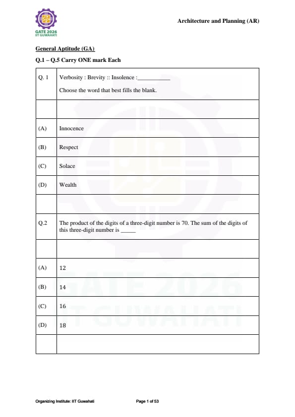
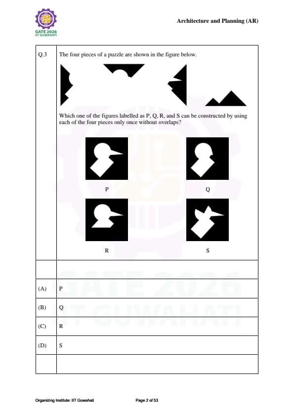
GATE 2026 Maths & Aptitude Important Questions
*The article might have information for the previous academic years, please refer the official website of the exam.